Çandarlı
Çandarlı | |
|---|---|
 | |
| Coordinates: 38°56′16″N 26°55′58″E / 38.9377°N 26.9327°E | |
| Country | Turkey |
| Province | İzmir |
| District | Dikili |
| Population (2022) | 8,021 |
| Time zone | UTC+3 (TRT) |
| Area code | 0232 |
Çandarlı is a neighbourhood in the municipality and district of Dikili, İzmir Province, Turkey.[1] Its population is 8,021 (2022).[2] Before the 2013 reorganisation, it was a town (belde).[3][4]
It is a well-developed coastal town and an important tourist resort. It is a fishing village, where a lot of daily life revolves around such, with many people having jobs surrounding the fishing industry, making nets, gutting and cooking the fish, not to forget the fisherman themselves. In summer the population nearly doubles with tourists, normally domestic tourists rather than international. Çandarlı is situated on the northern coast of the Gulf of Çandarlı, opposite the important industrial center of Aliağa.
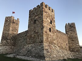
The town's landmark is the 15th century
Çandarlı Halil Pasha the Younger also gave the town its present name, naming it after his own family. Çandarlı's name in antiquity was Pitane. The ruins are situated slightly outside the town itself.
See also
- Çandarlı family
- Çandar
References
- ^ Mahalle, Turkey Civil Administration Departments Inventory. Retrieved 12 July 2023.
- TÜİK. Retrieved 12 July 2023.
- ^ "Law No. 6360". Official Gazette (in Turkish). 6 December 2012.
- ^ "Classification tables of municipalities and their affiliates and local administrative units" (DOC). Official Gazette (in Turkish). 12 September 2010.


