
Île Saint-Louis
48°51′06″N 2°21′23″E / 48.85167°N 2.35639°E
| Île Saint-Louis | |
|---|---|
 | |
 |
Île Saint-Louis (French: [il sɛ̃ lwi]), eleven hectares (27 acres) in size, is one of two natural islands in the Seine river, in Paris, France (the other natural island is the Île de la Cité, where Notre-Dame de Paris is located). Île Saint-Louis is connected to the rest of Paris by four bridges to both banks of the river and to the Île de la Cité by the Pont Saint-Louis.[1]
The island is located within the 4th arrondissement of Paris and has a population of 4,453.
History
-
 Île aux Vaches and Île Notre-Dame in Vassalieu Plan (1609)
 -
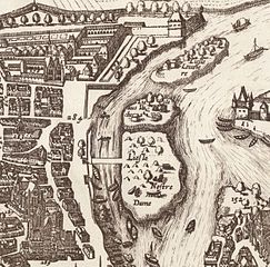 The islands Île aux Vaches and Île Notre-Dame in 1618
 -
 Île Saint-Louis in Turgot Map (1739)


The island was first known as the Île Notre-Dame, and was used mostly for grazing cattle, fishing, drying laundry, and occasionally for fighting duels.[2] In 1360 it was cut in half by a canal, at about the current Rue Poulettiere, in order to bring it into the protection of the new wall around the city built by King Charles V, The slightly smaller eastern portion was named the Ile des Vaches (Island of Cows) (not to be confused with another island of the same name farther downstream). That portion was used for storing wood and building boats.[2]
It was originally owned by the chapter of Notre-Dame cathedral.
Marie de Medicis promised a long series of benefits, including tennis courts and laundry boats for washing clothing and linen, to those who purchased lots and built houses on the island. She succeeded in attracting magistrates and financiers, but few aristocrats, who preferred the Marais quarter, which had larger plots of land and places for gardens. She also met resistance from the Chapter of Notre Dame, which owned considerable property on the island. Their resistance eventually drove the developer Christophe Marie into bankruptcy. In the end, the houses of the wealthy occupied waterside properties, while the interior was occupied by merchants and artisans.[5]
The island did not take the name of Saint-Louis until 1725.
During the French Revolution, the island was briefly renamed "Ile de la Fraternité".[3]
Plan

Description
Quai d'Anjou
The Quai d'Anjou on the north side of the island, was named for
Quai de Bourbon

The Quai de Bourbon was named for the royal family and has a series of very elegant townhouses constructed in the early 17th century. It was briefly the Quai de la Republique after the Revolution, but took back it original name in 1814. The house at 1 quai de Bourbon was occupied by
The Pont Saint-Louis is the only bridge connecting the two islands, and is 60 metres (200 ft) long. The first bridge, of wood, was built in 1634. The current bridge, the ninth, was opened in 1970.[8]
Quai de Bethune

The Quai de Bethune runs along the southeast side of the island. It was built shortly after the assassination of Henry IV, and is named for the late king's prime minister,
The quai was originally informally called the "Quai des Balcons" because the architect, Louis LeVau, promoted the idea that all of he buildings should have balconies, taking advantage of the southern exposure of he buildings.
Quai d'Orleans


The Quai d'Orleans continues the Quai de Bethune to the west. Like the Quai d'Anjou, it is named for Gaston d'Orleans, the younger brother of Louis XIII. During the French Revolution, it was renamed the Quai d'Egalite until 1806. It joins the Quai de Bourbon at the Saint-Louis bridge, close to the western point of the island. Its notable buildings include the Polish Library (number 6 quai d'Orleans), originally built for
The responsibility for the development of the Île Saint-Louis in the 17th century was given to Christophe Marie, general builder for Public Works. In exchange for his
For the first time, dwellings were orientated towards the outside, rather than towards an inner courtyard, with windows and balconies looking out to river views. Courtyards were narrow, with the usual gardens almost nonexistent. The majority of the façades were rather sober, providing charm to the neighborhood. Only a few façades were decorated with heads or faces (mascrons). Only a few of the balconies were adorned with ornate
Rue Saint-Louis-en-l'Île and the Hôtel Lambert

The Rue Saint-Louis-en-l'Île is the main commercial street of the island. It is located in the center of the island, going east to west from one end to the other. Despite its commercial character, it still retains many early residential buildings, the most notable of which is Hôtel Lambert, located at the Quai Anjou on the eastern end of the island. This large town house, with a rotunda overlooking the Seine, was constructed beginning in 1640 by the royal architect, Louis Le Vau.[13][14]
Due to the proximity of the site to the river it was not possible to follow the traditional model of a courtyard in the front and a garden in the back, so Le Vau built the garden and courtyard side by side, with the garden raised to the level of the first floor, or noble floor. The first interior painted decoration was done by Eustache Le Sueur; some of his original panels are now on display in the Louvre. The Hercules Gallery was designed by Charles Le Brun, whose future work for Louis XIV included the Hall of Mirrors in the Palace of Versailles.[13][14]
Over the years the house had a remarkable series of occupants. In the 18th century, it was purchased by the Marquis de Chatelet, whose wife, Émilie de Breteuil, was for fifteen years the mistress of
Church of Saint-Louis-en-l'Île

The Church of Saint-Louis-en-l'Île, at 19 bis rue Saint-Louis-en-l'Ile, is the only church on the island. It was designed by the architect François Le Vau younger brother of the better-known royal architect Louis Le Vau. It was the only building he designed. The first stone was placed on 1 October 1664 by the Archbishop of Paris, but work was delayed by a shortage of funds and it was not completed until 14 July 1726.[16]
The church lacks the traditional west front which had featured in the plans. Due to the delay in the construction, houses were built next to the church, taking the space. The original bell tower was destroyed by a storm in 1740, and was replaced by a new openwork tower. An unusual feature of the tower is the clock, which hangs over the street like a shop sign.[17]
The interior is a good example of
Square Barye

Square Barye, on the southeast point of the island, is shaped like a prow of a ship pointing into the Seine. It was originally the site of a convent. It occupies 3,000 square metres (32,000 sq ft), and is a popular park and garden. It takes its name from the 19th-century French sculptor Antoine-Louis Barye, who specialized in sculpture of animals. His work is prominently displayed in the square in front of the Musée d'Orsay.[18]
The most prominent art work in the square is a sculpture of Barye depicting the combat between a mythological
Bridges that connect to the Île

- Pont Saint-Louis from the Île de la Cité;
- Pont de la Tournelle from the Rive Gauche;
- Pont Louis-Philippe from the Rive Droite;
- Pont Marie from the Rive Droite;
- Pont Sullyfrom the Rive Droite and the Rive Gauche.
See also
References
- ^ Lecompte 2013, p. 132.
- ^ a b Fierro 1996, p. 941.
- ^ a b c d Fierro 1996, p. 943.
- ^ Lecompte 2013, p. 134.
- ^ Lecompte 2013, p. 137.
- ^ Lecompte 2013, p. 138.
- ^ Lecompte 2013, p. 146.
- ^ Lecompte 2013, p. 150.
- ^ a b c Lecompte 2013, pp. 178–182.
- ^ a b Lecompte 2013, p. 181.
- ^ Lecompte 2013, pp. 186–189.
- ^ Carr, Kelby. "Paris Neighborhoods: The Ile Saint Louis". About.com Travel. Retrieved 2 April 2015.
- ^ a b Lecompte 2013, p. 158.
- ^ a b Poisson 2009, p. 250.
- ^ Lecompte 2013, p. 159.
- ^ a b Lecompte 2013, p. 161.
- ^ Lecompte 2013, p. 160.
- ^ Lecompte 2013, pp. 176–77.
Bibliography
- Fierro, Alfred (1996). Histoire et dictionnaire de Paris. Robert Laffont. ISBN 2-221--07862-4.
- Lecompte, Francis (2013). Notre-Dame, Île de la Cité et Île Saint-Louis (in English and French). Massin. ISBN 978-2-7072-0835-4.
- Poisson, Michel (2009). 1000 Immeubles et Monuments de Paris. Parigramme. ISBN 978-2-84096-539-8.
- ISBN 0-9769251-0-9: "Island in the Seine", pp. 10–17
- DeJean, Joan. "'Enchanted Island': The Ile Saint-Louis" in her How Paris Became Paris: The Invention of the Modern City. New York: Bloomsbury, 2014. ISBN 978-1-60819-591-6. Chapter 3, pp. 62–76.
External links
- L'Île Saint Louis: current photographs and of the years 1900
- Île Saint Louis information : history and today
- Places to visit in Île St Louis