
2016 Kumamoto earthquakes
This article has multiple issues. Please help improve it or discuss these issues on the talk page. (Learn how and when to remove these template messages)
|
Mercalli intensity scale value of 8.8 was observed just east of Kumamoto City.[1] | |
 | |
| UTC time | 2016-04-15 16:25:06 |
|---|---|
| ISC event | 610289055 |
| USGS-ANSS | ComCat |
| Local date | April 16, 2016[2] |
| Local time | 01:25 JST (UTC+9) |
| Magnitude | 7.0 Mw[2] 7.3 MJMA |
| Depth | 10 km[3] |
| Epicenter | 32°46′55.2″N 130°43′33.6″E / 32.782000°N 130.726000°E[2] |
| Fault | Futagawa-Hinagu fault zone |
| Type | Strike-slip |
| Areas affected | Kumamoto Prefecture, Kyushu, Japan[4] |
| Max. intensity | JMA 7 (MMI IX) |
| Peak acceleration | 1.61 g (foreshock) 1580 Gal (foreshock) 1.83 |
| Casualties | 273 dead, 2,809 injured(including indirect deaths)[7][a] |
The 2016 Kumamoto earthquakes (
In total, the two earthquakes killed 273 people and injured 2,809 others, a majority of them indirectly,[7][11] making this the deadliest earthquake sequence in Japan since the 2011 Tōhoku earthquake and tsunami.[12] Severe damage occurred in Kumamoto and Ōita Prefectures, with numerous structures collapsing and catching fire. More than 44,000 people were evacuated from their homes due to the disaster.
Earthquakes
April 14 foreshock
.svg)
Although the focus of the
Intensity
|
Prefecture | Location |
|---|---|---|
| 7 | Kumamoto | Mashiki
|
| 6- | Kumamoto | Kumamoto (Higashi-ku, Nishi-ku, Minami-ku), Tamana, Uki, Nishihara |
April 16 mainshock
At 01:25
| Intensity | Prefecture | Location |
|---|---|---|
| 7 | Kumamoto | Mashiki
|
| 6+ | Kumamoto | |
| 6- | Kumamoto | Kamiamakusa, Amakusa
|
Oita
|
Beppu, Yufu |
Aftershocks
The following is a list of major aftershocks that have occurred in Kumamoto Prefecture since April 14, 2016.
| Japan Time | Magnitude | Intensity | Comment |
|---|---|---|---|
| 2016-04-14 21:26 | Mj6.5, Mw6.2 | 7 | Foreshocks |
| 2016-04-14 22:07 | Mj5.8 | 6- | |
| 2016-04-15 00:03 | Mj6.4 | 6+ | |
| 2016-04-16 01:25 | Mj7.3, Mw7.0 | 7 | Mainshock |
| 2016-04-16 01:45 | Mj5.9 | 6- | Aftershocks |
| 2016-04-16 03:03 | Mj5.9 | 5+ | |
| 2016-04-16 03:55 | Mj5.8 | 6+ | |
| 2016-04-18 20:41 | Mj5.8 | 5+ | |
| 2016-04-19 17:52 | Mj5.5 | 5+ |
Damage and casualties
As a result of the tremors, the entirety of Kumamoto city was left without water.
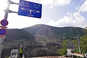
Numerous landslides took place across the mountains of Kyushu, rendering roads impassable,
The Aso Shrine was also heavily damaged in the earthquake. The shrine's rōmon (tower gate), officially classified as an Important Cultural Property by the Japanese government, and the haiden (worshiping hall) both completely collapsed.[32] Kumamoto Castle, another Important Cultural Property sustained damage to its roof and exterior buildings and walls because of the earthquakes and associated aftershocks.[33] Several of the castle's shachihoko ornaments were destroyed,[34] and a large number of kawara tiles also fell from the roof. Other historical buildings such as Janes' Residence, the first western-style house built in Kumamoto (dating from 1871)[35] were also totally destroyed.[36] The former registered Cultural Asset was initially located in the grounds of Kumamoto Castle, but was later relocated near Suizen-ji Jōju-en.
Early estimates of the economic costs of the damage range from $5.5 billion to $7.5 billion, with insured property losses estimated to be between $800 million to $1.2 billion, according to Risk Management Solutions or between $1.7 billion to $2.9 billion, according to Guy Carpenter.[37] Through the first half of 2016, about $3.2 billion of claims for damage to residential dwellings were paid out by insurance companies, according to data from the General Insurance Association of Japan.[38]
At least nine people lost their lives and approximately 1,000 more were injured by the April 14 foreshock.
At least 273 people were killed and 2,809 others were injured by the mainshock, including many indirectly.[7][39] Kumamoto Prefectural Police got more than 300 calls and also Ōita Prefectural Police took 100 calls, some reporting people trapped or buried under debris.[40] More than 91,700 people were evacuated. An additional 15,000 soldiers from the Japan Self-Defense Forces joined relief efforts following the earthquake.[41] By April 18, the number of people seeking shelter had risen to 180,000, while at least eight people remained missing in a landslide caused by the earthquake.
-
 The Great Aso Bridge in Minamiaso collapsed into the Kurokawa River due to a landslide
 -
![The north-west Inui Turret and wall of Kumamoto Castle.[42]](//upload.wikimedia.org/wikipedia/commons/thumb/0/0d/2016_Kumamoto_earthquake_Kumamoto_Castle_4.JPG/180px-2016_Kumamoto_earthquake_Kumamoto_Castle_4.JPG) The north-west Inui Turret and wall of Kumamoto Castle.[42]
The north-west Inui Turret and wall of Kumamoto Castle.[42] -
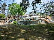 The ruins of the historic Janes' Residence
 -
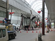 The damaged Sunlive Kengun in the pedestrian arcade in downtown Kumamoto.

![The north-west Inui Turret and wall of Kumamoto Castle.[42]](/File:2016_Kumamoto_earthquake_Kumamoto_Castle_4.JPG)


Geology
Kumamoto Prefecture lies at the southern end of the Japan Median Tectonic Line, Japan's longest, where a system of active faults forks in two directions at the Beppu-Haneyama Fault Zone.[43] Specifically, the series of quakes ruptured the 81-km-long Hinagu Fault and 64-km-long Futagawa Fault to its north, as well as lesser but discernable interaction with the farther flung Beppu-Haneyama Fault Zone.[44][45] A 27-km section of the Futagawa Fault Zone slid 3.5 meters.[45] The earthquakes are occurring along the Beppu–Shimabara graben,[46] with epicentres moving from west to east over time.[47]
Around 08:30 local time on 16 April, Mount Aso saw a small-scale eruption with ash billowing 100 m (330 ft) into the air; the eruption was not related to the earthquake.[48][49] Mount Aso had already been active since before the earthquakes,[50] being under a Level 2 warning from the JMA since November 24, 2015.[51][52]
See also
References
Notes
Citations
- ^ "M7.0 – 1km WSW of Kumamoto-shi, Japan: Shake Map". United States Geological Survey. April 15, 2016. Retrieved April 15, 2016.
- ^ a b c d e f "M7.0 – 1km WSW of Kumamoto-shi, Japan". United States Geological Survey. Retrieved April 15, 2016.
- ^ "M7.0 – 1km WSW of Kumamoto-shi, Japan". earthquake.usgs.gov. Retrieved April 16, 2016.
- ^ a b c 平成28年4月14日21時26分頃の熊本県熊本地方の地震について [About the earthquake in the Kumamoto area of Kumamoto Prefecture, around 21:26, April 14, 2016]. Japan Meteorological Agency (in Japanese). April 14, 2016. Retrieved April 15, 2016.
- ^ =緊急地震速報の内容 [The contents of the Earthquake Early Warning]. Japan Meteorological Agency (in Japanese). April 14, 2016. Retrieved April 15, 2016.
- ^ "M6.2 – 7km SW of Ueki, Japan". United States Geological Survey. Retrieved April 15, 2016.
- ^ .
- ^ a b c d Doug Stanglin (April 16, 2016). "Hospital evacuated after major quake rocks Japanese island". USA Today. Retrieved April 16, 2016.
- ^ "70% of Kumamoto victims died in collapsed homes:The Asahi Shimbun". Asahi.com. May 1, 2016. Archived from the original on May 9, 2016. Retrieved May 9, 2016.
- ^ "M7.0 – 1km WSW of Kumamoto-shi, Japan". USGS Earthquake Hazards Program. Retrieved April 15, 2016.
- ^ Fire and Disaster Management Agency (April 12, 2019). "熊本県熊本地方を震源とする地震(第121報)" (PDF). Japan Meteorological Agency (in Japanese). Retrieved March 25, 2021.
- ^ Lawson, Hugh (January 2, 2024). Lisa Shumaker (ed.). "Japan's major earthquakes since the 1995 Kobe disaster". Reuters. Retrieved January 2, 2024.
- ^ "At Least 10 Dead, More Than 800 Injured in Japan 6.5-Magnitude Earthquake". ABC News. April 15, 2016. Retrieved April 15, 2016.
- ^ 地震情報(各地の震度に関する情報) [Earthquake Information: Information on the Seismic Activity in Affected Areas] (in Japanese). Japan Meteorological Agency. April 14, 2016. Archived from the original on April 14, 2016. Retrieved April 15, 2016.
- ^ "6.2 Magnitude Earthquake Hits Southern Japan, Killing 2; Homes Collapse, 45 Injured".
- ^ "More aftershocks feared after strong quake in southwestern Japan". Nikkei Asian Review. April 15, 2016. Archived from the original on April 16, 2016. Retrieved April 15, 2016.
- ^ a b Daisuke Kikuchi (April 15, 2016). "Kumamoto residents pick up the pieces following Kyushu's strongest quake". The Japan Times. Retrieved April 15, 2016.
- ^ The 2016 Kumamoto Earthquake –Portal –Earthquake Summary Retrieved 17 April 2016 (archive)
- ^ "震度データベース検索 (Foreshock)". www.data.jma.go.jp. Archived from the original on November 13, 2020. Retrieved June 23, 2021.
- ^ "地震情報 04月14日 21時26分頃発生 最大震度:7". tenki.jp (in Japanese). April 14, 2016. Retrieved June 23, 2021.
- ^ "M 5.1 – 11km WSW of Beppu, Japan". earthquake.usgs.gov. Retrieved April 16, 2016.
- ^ "Magnitude 3 Tremors Felt in Southern Region". Archived from the original on April 17, 2016. Retrieved April 16, 2016.
- ^ a b c d Don Melvin; Greg Botelho; Ray Sanchez (April 16, 2016). "7.0 quake strikes Japan; rescuers try to free residents". CNN. Retrieved April 16, 2016.
- ^ "Japan Meteorological Agency Tsunami Warnings/Advisories, Tsunami Information". www.jma.go.jp. Retrieved April 17, 2016.
- ^ "震度データベース検索 (Mainshock)". www.data.jma.go.jp. Archived from the original on November 13, 2020. Retrieved June 23, 2021.
- ^ "地震情報 04月16日 01時25分頃発生 最大震度:7". tenki.jp (in Japanese). April 16, 2016. Retrieved June 23, 2021.
- ^ a b "2nd Japanese earthquake leaves at least 3 dead, 400 injured". CBC News. April 16, 2016. Retrieved April 14, 2016.
- ^ "Aftershocks rattle southwestern Japan after quake kills nine". Reuters. April 15, 2016. Retrieved April 15, 2016.
- ^ "Eleven people remain missing in southern Japan from two powerful earthquakes that killed 41 people". US News. April 17, 2016. Retrieved April 17, 2016.
- ^ "Photos: Second Devastating Earthquake Hits Japan Triggering Landslides". NBC News. April 16, 2016.
- ^ "Large road bridge collapses as new quake hits Kumamoto". Asahi Shimbun. April 16, 2016. Archived from the original on December 21, 2016. Retrieved April 16, 2016.
- ^ "Designated national cultural asset at Aso Shrine collapses in Kumamoto quake". Mainichi Shimbun. April 16, 2016. Retrieved April 16, 2016.
- ^ "Quake damages roof, walls at Kumamoto Castle". Asahi Shimbun. April 15, 2016. Archived from the original on April 18, 2016. Retrieved April 15, 2016.
- ^ 熊本城 地震で「しゃちほこ」なくなる [Kumamoto Castle: The Earthquake Destroys the Castle's 'Sachihako'"] (in Japanese). NHK. April 15, 2016. Archived from the original on April 15, 2016. Retrieved April 15, 2016.
- ^ "The Janes' Residence Kumamoto". www.japanvisitor.com. Retrieved April 20, 2016.
- ^ "明治4年の西洋建築 「ジェーンズ邸」が倒壊" (in Japanese). Archived from the original on April 15, 2016. Retrieved April 20, 2016.
- ^ Hoffman, Mark (May 12, 2016). "April's Japan earthquake insured damage could top $1 billion". Business Insurance. Retrieved May 16, 2016.
- ^ "Kumamoto quake residential insurance claims paid hits $3.2bn". Artemis. Steve Evans Ltd. June 30, 2016. Retrieved July 1, 2016.
- ^ "Japanese Quake Death Toll Rises, U.S. Helps Deliver Aid". USN. April 18, 2016. Retrieved April 18, 2016.
- ^ "Japan hit by 7.3-magnitude earthquake". The Guardian. Retrieved April 17, 2016.
- ^ Caroline Mortimer (April 16, 2016). "Japan earthquake: Tsunami alert after 7.3 tremor his south of country – 24 hours after 10 died in separate quake". The Independent. Archived from the original on May 1, 2022. Retrieved April 16, 2016.
- ^ "Japan earthquakes breach walls of 400-year-old Kumamoto castle". Australian Broadcasting Corporation. April 16, 2016. Retrieved April 18, 2016.
- ^ "Unusual quake cluster worries Japan – Nikkei Asian Review". asia.nikkei.com. Archived from the original on April 19, 2016. Retrieved January 12, 2022.
- ^ "Chain reaction activated separate fault zone in 2nd huge quake – Japan Today: Japan News and Discussion". Archived from the original on April 17, 2016. Retrieved April 19, 2016.
- ^ a b asia.nikkei.com/Features/Kyushu-earthquakes/Unusual-quake-cluster-worries-Japan
- ^ "Kyushu". Introduction to the Landforms and Geology of Japan. GLGArcs. Archived from the original on April 10, 2016. Retrieved April 16, 2016.
- ^ "Seismic activity could move east, trigger quakes in active faults". The Asahi Shimbun. The Asahi Shimbun Company. Retrieved April 16, 2016.
- ^ "Small eruption seen on Mount Aso after latest quakes". The Japan Times. Reuters. April 16, 2016. Retrieved April 16, 2016.
- ^ Otake, Tomoko; Aoki, Mizuho; Yoshida, Reiji (April 18, 2016). "Questions and answers: The Kumamoto earthquakes". The Japan Times Online. Retrieved April 21, 2016.
- ^ "Small-scale eruption at Mt. Aso in Kumamoto not related to quakes: volcanologist". The Mainichi Newspapers. Mainichi, Japan. April 16, 2016. Retrieved April 16, 2016.
- ^ "Volcanic Warnings". Japan Meteorological Agency. Retrieved April 16, 2016.
- ^ "Aso Volcanic Warning Level Lowered to Level 2, Entry Allowed Up to Mt. Aso Rope Way Asosan-Nishi Station". Kumamoto Prefectural Tourist Board. 熊本県観光課. Retrieved April 16, 2016.
External links
- The 2016 Kumamoto Earthquake –Portal – Japan Meteorological Agency
- Magnitude 6.2 Earthquake in Japan – United States Geological Survey
- Magnitude 7.0 Earthquake in Japan – United States Geological Survey
- Earthquake and Volcano Information – 15th April, 2016 Earthquake in Kumamoto prefecture – Earthquake Research Institute, University of Tokyo
- The International Seismological Centre has a bibliography and/or authoritative data for this event.
| Authority control databases: National |
|---|