
2021 Uttarakhand flood
 The state of Uttarakhand within India | |
| Date | 18 February 2021 |
|---|---|
| Cause | Ice and rock avalanche |
| Deaths | 83 121 missing |
| Property damage | Most houses are damaged. Few houses that remain undamaged on the site were covered in slush up to 21 feet deep. |


The 2021 Uttarakhand flood, also known as the Chamoli disaster,
Cause
According to early reports, the flooding was speculated to have been caused by a portion of the
According to BBC News, four scientists from the Wadia Institute of Himalayan Geology, Dehradun, India flew over the site in a helicopter, took photographs, and gathered other data; they consider the hanging glacier that cracked and plunged into the Rishiganga basin, to have been attached to a subsidiary peak, Raunthi, 5,600 m (18,372 ft), just below Nanda Ghunti (Map 3, Ronti, at the intersection of 81 and 423).[13] According to Dr. Kalachand Sain, director of the Wadia Institute, climate change is the major factor in the rapid freezing and thawing of ice that causes glacier fractures.[14] A subsequent analysis by Carbon Brief highlighted how though climate change probably didn't directly cause the outburst – instead a landslide or similar geological change triggered it – however, the environmental changes caused by climate change probably contributed to the geographic conditions that allowed for the disaster.[15]
In June 2021, the International Charter 'Space and Major Disasters' published a study that confirmed a large rock and ice avalanche as the cause of the disaster.[4] The result was based on data from earth observation satellites, as well as seismic records, numerical model results, and eyewitness videos. The authors estimate the avalanche at about 27 million cubic meters, consisting of 80% rock and 20% glacier ice. The glacier ice turned into water over the course of the 3.2 km elevation difference from the peak, which further worsened the impact by causing a debris flood wave.[5]
Casualties and damage
Among the places most severely hit by the floods are Joshimath, Rini, Nanda Devi National Park, Tapovan Vishnugad Hydropower Plant and Sridhar.[16]
The disaster left over 200 killed or missing. The 13-megawatt Rishiganga power project in Rini, on the
Relief measures
Many villages were
In the aftermath of the floods, residents in Joshimath began noticing cracks in homes; eventually over 600 houses were evacuated after a local temple collapsed.[26][27]
Environmental concerns
The geographic state of the area prior to the disaster has been described as "fragile".[15][28] According to The New York Times, scientists had warned the Government of India for many years that the Himalayas had been warming at a dangerously high rate and the region's ecosystem had become too physically exposed to the dangers of development projects.[29] Dr. Ravi Chopra, the director of the People's Science Institute in Uttarakhand and a member of a scientific committee appointed by India's Supreme Court in 2014, had advised against building dams in the paraglacial zone, i.e. river valleys in which the floor is higher than 7,000 feet (2,100 m), but the Government of India disregarded their objections.[29] According to Dr. Chopra, both the hydro-electric power projects that were washed away in the flood were constructed in this zone.[28] According to another committee led by Dr. Chopra and appointed by India's Supreme Court in 2020, per the New York Times, the Government of India had built 500 miles (800 km) of highway—much 33 feet (10 m) wide—in the hills of Uttarakhand in order to improve approaches to Hindu temples in the high Himalayas, overriding the advice of its own experts,[30] The headman of Reni, the village most adversely affected by the flood, stated that the village residents feared that the blasting of the rocks during the hydropower dam's construction would bring on dangerous landslides.[29] “We used to hear blasting and see the rocks shift,” he said. “When this project was under construction, half of our village slid. We requested to be shifted from here to another place. The government said they would do it, but it never happened.”[29]
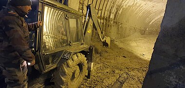
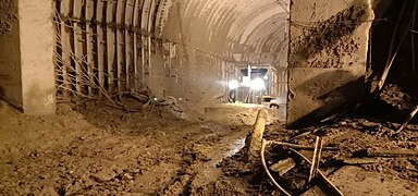
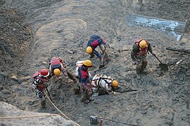
Gallery
The rescue operation at NTPC's Tapovan Vishnugad Hydropower Plant – Tunnel 1;
-
 Rescue operation at the Tunnel 1 of Tapovan Vishnugad Hydropower Plant, Date: 8 February 2021
 -
 Rescue operation at the Tunnel 1 of Tapovan Vishnugad Hydropower Plant, Date: 8 February 2021
 -
 Rescue operation at the Tunnel 1 of Tapovan Vishnugad Hydropower Plant, Date: 8 February 2021


The rescue operation at NTPC's Tapovan Vishnugad Hydropower Plant – Tunnel 2;
-
 Rescue operation at the Tunnel 2 of Tapovan Vishnugad Hydropower Plant, Date: 8 February 2021
 -
 Rescue operation at the Tunnel 2 of Tapovan Vishnugad Hydropower Plant, Date: 8 February 2021
 -
 Rescue operation at the Tunnel 2 of Tapovan Vishnugad Hydropower Plant, Date: 8 February 2021
 -
 Rescue operation at the Tunnel 2 of Tapovan Vishnugad Hydropower Plant, Date: 8 February 2021


See also
References
- ^ "Chamoli disaster: 'It hit the valley floor like 15 atomic bombs'". BBC. 13 June 2021. Retrieved 1 July 2021.
- ^ "Nanda Devi and Valley of Flowers National Parks", India: Properties inscribed on the World Heritage List, UNESCO, retrieved 9 February 2021
- ^ "Uttarakhand flood wreaks death, damage". The Indian Express. 8 February 2021. Retrieved 8 February 2021.
- ^ S2CID 235402626.
- ^ a b "Satellites reveal cause of Chamoli disaster". www.esa.int. Retrieved 15 June 2021.
- ^ "Uttarakhand news live: Glacier bursts in Uttarakhand's Chamoli district". The Times of India. Retrieved 7 February 2021.
- ^ "Glacier bursts in Uttarakhand's Chamoli district, causing flash flood in Dhauliganga: Highlights – Times of India". The Times of India. Retrieved 7 February 2021.
- ^ Banerjee, Biswajeet; Jain, Rishabh R. (8 February 2021). shree Ram the glacier outburst in uttrakhand 2021-updates-782497632330d11acdb3b53c277283e8 "Rescuers in India digging for 37 trapped in glacier flood". Associated Press. Retrieved 8 February 2021.
{{cite web}}: Check|url=value (help) - ^ Sandhya Ramesh (8 February 2021). "Uttarakhand disaster likely caused by landslide, not glacial outburst, satellite images reveal". ThePrint. Retrieved 8 February 2021.
- ^ Dave Petley, Dan Shugar (8 February 2021). "Uttarakhand disaster likely caused by landslide, not glacial outburst, satellite images reveal". AGU. Retrieved 8 February 2021.
- ^ Tomlinson, Hugh; Kuchay, Bilal (13 February 2021), "Himalaya disaster in Uttarakhand exposes risks of India's rush for green energy", The Times, Delhi and Uttarakhand, retrieved 13 February 2021
- ^ Harper, Kelso (12 February 2021), Miniature Satellites Reveal Cause of Deadly Uttarakhand Flood That Devastated Hydroelectric Dams, Scientific American,
Roughly six hours after the flood, Shugar pulled up the latest Planet Labs satellite images and discovered a trail of dust and a dark scar on the pearl-white peaks above the flood zone – clear signs of a landslide. ... He saw that an enormous hanging glacier, roughly 15 football fields long and five across, had broken from the steep face of a mountain and plummeted downward, bringing some of the rock face down with it. Shugar says this ice and rock avalanche crashed into the Ronti Gad, a smaller tributary that feeds into the Rishiganga and then Dhauliganga rivers.
- ^ Biswas, Soutik (11 February 2021), "'Hanging' glacier broke off to trigger India flood", BBC News, retrieved 16 February 2021
- ^ Biswas, Soutik (11 February 2021), "'Hanging' glacier broke off to trigger India flood", BBC News, retrieved 16 February 2021,
Climate change, he said, is the "main factor" for rapid temperature changes leading to freezing and thawing of ice, and glacial fractures over time. Glaciers collect snow in winter, and lose snow in summer. But when temperatures rise, they lose ice faster than they can collect it. Ice melts can lead to the retreat of glaciers.
- ^ a b "Factcheck: Did climate change contribute to India's catastrophic 'glacial flood'?". Carbon Brief. 9 February 2021. Retrieved 26 March 2021.
- ^ "टुटा ग्लेशियर ,मची तबाही". The Nitrrsh (in Hindi). 7 February 2021. Retrieved 7 February 2021.
- ^ "Uttarakhand Tragedy: One More Body Recovered from Tapovan Tunnel, Death Toll Rises to 83". News18. 14 May 2021. Retrieved 5 August 2021.
- ^ "Sinds de bergen rond Raini brullend tot leven kwamen, is het Indiase dorp slapeloos" [Since the mountains around Raini roared to life, the Indian village has been sleepless]. NRC (in Dutch). Archived from the original on 5 August 2021. Retrieved 5 August 2021.
- ^ Scroll Staff. "Uttarakhand glacier burst: Over 100 missing, power plant damaged in Chamoli". Scroll.in. Retrieved 7 February 2021.
- ISSN 0362-4331. Retrieved 7 February 2021.
- ^ "Rishiganga hydro project, Tapovan dam washed away by glacier burst in Uttarakhand". Times Now. 8 February 2021. Retrieved 8 February 2021.
- ^ "Uttarakhand: Eleven dead after India glacier bursts dam". BBC News. 8 February 2021. Retrieved 8 February 2021.
- ^ Akanksha Sharma, Vedika Sud and Swati Gupta. "More than 150 missing and 14 dead as burst glacier triggers flash floods in India". CNN. Retrieved 8 February 2021.
- ^ "Uttarakhand glacier disaster: Fourteen dead after India glacier bursts dam". BBC News. 8 February 2021. Retrieved 8 February 2021.
- ^ "Glacier breaks in India's north; flood kills 9, 140 missing". AP NEWS. 7 February 2021. Retrieved 7 February 2021.
- ^ B. Banerjee (7 January 2023), "Sinking land forces hundreds to leave Indian temple town", ABC News, retrieved 8 January 2023
- ^ "The scenic Indian town in danger of sinking", BBC News, 5 January 2023, retrieved 8 January 2023
- ^ a b Mashal, Mujeeb; Kumar, Harry (8 February 2021), "Before Himalayan Flood, India Ignored Warnings of Development Risks: Long before a deadly flood hit two hydroelectric dams, scientists warned repeatedly that such projects were dangerous in a fragile region made more so by global warming.", New York Times, retrieved 16 February 2021,
"But the government has gone ahead and chosen to build them," he (Dr. Chopra) said. Both of the hydroelectric projects hit by Sunday's flood — one obliterated and the other badly damaged — were built in that zone, he said.
- ^ a b c d Mashal, Mujeeb; Kumar, Harry (8 February 2021), "Before Himalayan Flood, India Ignored Warnings of Development Risks: Long before a deadly flood hit two hydroelectric dams, scientists warned repeatedly that such projects were dangerous in a fragile region made more so by global warming.", New York Times, retrieved 16 February 2021
- ^ Mashal, Mujeeb; Kumar, Harry (8 February 2021), "Before Himalayan Flood, India Ignored Warnings of Development Risks: Long before a deadly flood hit two hydroelectric dams, scientists warned repeatedly that such projects were dangerous in a fragile region made more so by global warming.", New York Times, retrieved 16 February 2021,
"The government is building more than 500 miles of highway in Uttarkhand to improve access to several major Hindu temples, despite environmentalists' objections to the massive forest clearance required, which can hasten erosion and raise the risk of landslides. A scientific committee appointed by India's Supreme Court and led by Dr. Chopra concluded last year that the government, in building the highway to the width of 10 meters, about 33 feet, had gone against the advice of its own experts at the Transport Ministry.
External links
 Media related to 2021 Nanda Devi glacier disaster at Wikimedia Commons