Aarhus County

Coordinates: 56°09′N 10°12′E / 56.15°N 10.20°E / 56.15; 10.20
Source: Wikipedia, the free encyclopedia.
Aarhus County
Århus Amt (Danish)
Basic Facts
County seat Århus
Area 4,561 km2
Inhabitants 661,370 (2006)
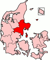
Map
Aarhus County in Denmark

Aarhus County or Århus County (

Region Nordjylland (Region North Jutland). At the time of its abolishment, more than 20,000 people worked for the county.[1]

Logo of the former county

Municipalities (1970-2006)

  • Aarhus municipality
  • Ebeltoft municipality
  • Galten municipality
  • Gjern municipality
  • Grenaa municipality
  • Hadsten municipality
  • Hammel municipality
  • Hinnerup municipality
  • Hørning municipality
  • Langå municipality
  • Mariager municipality
  • Midtdjurs municipality
  • Nørhald municipality
  • Nørre Djurs municipality
  • Odder municipality
  • Purhus municipality
  • Randers municipality
  • Rosenholm municipality
  • Rougsø municipality
  • Ry municipality
  • Rønde municipality
  • Samsø municipality
  • Silkeborg municipality
  • Skanderborg municipality
  • Sønderhald municipality
  • Them municipality

References

  1. ^ "Information about the County of Aarhus". Aarhus Amt. Archived from the original on 6 December 2007. Retrieved 23 July 2021.

56°09′N 10°12′E / 56.15°N 10.20°E / 56.15; 10.20