
Aberford
This article needs additional citations for verification. (March 2019) |
| Aberford | |
|---|---|
West Yorkshire | |
| Ambulance | Yorkshire |
Elmet and Rothwell | |
Aberford is a village and
Etymology
The name 'Aberford' comes from the Old English woman's name Ēadburg and ford, which, then as now, meant 'ford'. The name meant 'Eadburg's ford'.[4] This suggests the settlement's once-strategic importance.[5] The name was recorded as Ædburford in 1176 and Ædburgford in 1177, Ebberford in the 13th century and Aberford from 1208.[6]
History
Aberford was where the ancient
Aberford was in the ancient Kingdom of
Aberford's growth was along the road and the village has developed a linear rather than nucleated profile.
Geology
Geologically, Aberford lies slightly east of the narrow basal sandstone boundary between the central Leeds
Buildings
Aberford is considered "a place of special architectural and historic interest".[13] Some notable buildings are:
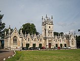
- St Ricarius Church. The parish church is an 1861 rebuilding of a 12th-century one.[14]
- The Gascoigne Almshouses designed by George Fowler Jones was built by sisters Mary Isabella and Elizabeth Gascoigne of Parlington Hall in 1844 to commemorate their father, Richard Oliver Gascoigne and two brothers who died in quick succession. They are grade II* listed buildings.[15]
- Aberford House is a classical 18th century mansion on Main Street.[16]
- The Swan Hotel, previously a staging post used by those travelling the Great North Road.[17]
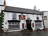
- The Arabian Horse Inn is one of a very few public houses in the UK with this name, and a landmark with the conservation area.[18]
Aberford
Gallery
-
 St Ricarius Church
 -
 The Swan a former public house
 -
 Gascoigne Almshouses
 -
 The Arabian Horse public house
 -
 Aberford Bridge over the Cock Beck. The arches show the former width
 -
 The Royal Oak a former public house


_002.JPG)


Location grid
Places adjacent to Aberford | |
|---|---|
See also
- Listed buildings in Aberford
References
- ^ Office for National Statistics. Retrieved 29 March 2019.
- ^ UK Census (2001). "Local Area Report – Aberford Parish (00DA001)". Nomis. Office for National Statistics. Retrieved 29 March 2019.
- ^ ANDP 2018, p. 7.
- ^ Harry Parkin, Your City's Place-Names: Leeds, English Place-Name Society City-Names Series, 3 (Nottingham: English Place-Names Society, 2017), p. 11.
- ^ ACAAMP 2011, pp. 5–6.
- ISBN 978-0521168557.
- ^ "Aberford & District Parish Council | Aberford". aberford-pc.gov.uk. Retrieved 29 March 2019.
- ^ ACAAMP 2011, p. 5.
- ^ "Aberford Bridge". British Listed Buildings. Retrieved 14 April 2017.
- ^ "Æthelswith Ring". British Museum Collection Online. Retrieved 22 September 2017.
- ^ ACAAMP 2011, p. 6.
- ^ ACAAMP 2011, p. 4.
- ^ ACAAMP 2011, p. 1.
- ^ "Parish Church of St Ricarius or St Riquier". British Listed Buildings. Retrieved 14 April 2017.
- ^ "Gascoigne Almshouses and Attached Wardens Cottage". British Listed Buildings. Retrieved 14 April 2017.
- ^ "Aberford House". British Listed Buildings. Retrieved 14 April 2017.
- ^ "The Swan Hotel". British Listed Buildings. Retrieved 14 April 2017.
- ^ ACAAMP 2011, p. 11.
- ^ Piper, Marolyn (4 December 2006). "The Lost Village of Hillam Burchard". Aberford People. Retrieved 29 March 2019.
- OCLC 1242784225.
Sources
- Aberford Conservation Area Appraisal and Management Plan (PDF). www.leeds.gov.uk (Report). Leeds City Council. 30 May 2011. Retrieved 29 March 2019.
- Aberford Neighbourhood Development Plan 2018–2028 (PDF). www.leeds.gov.uk (Report). Aberford District Council. 8 March 2018. Retrieved 29 March 2019.
External links
- Aberford community website with local news and parish council information
- A comprehensive History of Parlington Hall, and features associated with the hall like the Ice House, the Dark Arch and the Triumphal Arch.'
- Leeds's geology
- Aberford C of E School
- Roman Roads in Britain (large map, recommended that this is opened in a separate window)
- Details on the Great North Road
- The Aberford Railway (Fly Line), at the LNER Encyclopedia
- Photos of Aberford and surrounding area on geograph
- Leodis View photographs of Aberford on the Leeds photographic archive.
| Metropolitan districts | |
|---|---|
| Major settlements (cities in italics) |
|
| Topics |
|
| International | |
|---|---|
| National | |