
Aegviidu
Aegviidu
Charlottenhof | ||
|---|---|---|
Postal Codes 74501, 74594[4] | ||
Aegviidu is a borough in Anija Parish, Harju County, Estonia, most known for its picturesque surroundings and hiking trails.
The borough is situated along the
As of November 22, 2022, the borough had a population of 695.[2]
Etymology
Aegviidu was first mentioned in the will of
On the 1805 topographic map of the
Some sources claim that the name Aegviidu first appeared in the 18th century, when the Piibe road was being built through the local bogs, or in the 19th century, when the
Another theory claims that the name Aegviidu comes from the name of Saint Aegidius, which seems unlikely, as there are no surviving records of him being worshipped in Estonia.[6]
History
Early history
It is speculated that during the antiquity a winter road passed through the area of Aegviidu that connected Kehra and Jäneda.[12] The ancient Jäneda hillfort is located just a few kilometers southeast of current Aegviidu, on the coast of Kalijärv. The hillfort was likely in use between the 11th and 13th centuries.[13]
Kosenõmme (Cosgenomne), which is located in the northern part of modern Aegviidu, was given to Lehtse manor in 1379. In 1467, the Kosenõmme mill had been referred to as Kossgen-Nomme. By 1510, the mill had seemingly disappeared, when Kossenem only referred to a regular farm. In 1511, the farm had been referred to as Kaszenum.[14]
Aegviidu was first mentioned in the will of
Manor

On the 1805 topographic map of the Governorate of Estonia, the settlement was referred to as Charlottenhof,[8] likely a reference to Charlotte Dorothea von Friesell, wife of the then Lord of Lehtse.[11] In 1820, there are records of a coaching inn and a hunting lodge in the settlement. At approximately the same time, Chartlottenhof cattle manor (German: Hoflage, Estonian: Karjamõis) is also mentioned, being located near the current Piibe road railway crossing point and belonging to the Lehtse manor.[6] By the beginning of the 20th century, a post office, a pharmacy, and a general store had been built in the settlement. In 1917, the Lord of Lehtse gifted the Aegviidu hunting lodge to a local educational society and a school started operating there. Since the hunting lodge was not fit to be a schoolhouse, the educational society acquired the coaching inn from the Lord in 1919, and the school has operated there ever since.[16] The hunting lodge is currently used as a community center.[17]

On December 6, 1896, the Alexandra chapel of Aegviidu[18] was solemnly consecrated, being later renamed to Alexander chapel of Aegviidu. The current tower of the chapel was built in 1940. The chapel was badly damaged in the March bombings of 1944. The insides of the chapel were thoroughly renovated in the 1970s.[19] Lehtse manor, along its subsidiaries, was nationalized in 1919.[18]
Railway

In 1870, the
Just before the Estonian War of Independence, Konstantin Päts assigned Eduard Piibemann to organize the Aegviidu self-defense force. On the night of February 24, 1918, the force detained a Russian detachment near the railroad in Aegviidu and confiscated their weapons.[24] Although the Soviets briefly captured Aegviidu on January 1, 1919, the Estonians recaptured it by railway on January 5, 1919, a day after the decisive Battle of Kehra.


The Tallinn-Aegviidu railway line saw further development, with the first electrified train between Kehra and Aegviidu running on August 3, 1978, and the second pair of rails from Aegviidu to Kehra and Lehtse laid in 1987 and 1991, respectively.[25] The electrified part of the Tallinn-Tapa railway terminates roughly halfway between Aegviidu and Nelijärve railway stations. The new Stadler FLIRT trains began servicing the Tallinn-Aegviidu line on July 1, 2013.[26]
The
-
 Aegviidu railway station
 -
 End of electrified railway in Aegviidu
 -
 Aegviidu railway station building before renovation
 -
 Railway near Aegviidu


Politics
Aegviidu gained the rights of a summering borough in 1926 and the rights of a borough in 1945. Aegviidu has been a part of Tapa, Paide, and Harju regions since 1950, 1962, and 1962, respectively. The borough became self-governing on June 20, 1991, and became a borough-parish on August 25, 1993.[17] Aegviidu became a part of Anija parish on October 21, 2017.[27]
-
 Former flag of Aegviidu parish
 -
 Former coat of arms of Aegviidu parish


Geography
Nature
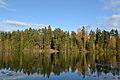
The nature of Aegviidu is characterized by its many hills, lakes, bogs, and huge forests. The area offers a range of hiking trails and well-developed infrastructure, including well-built roads, easy access, and gear rental points.[28]
The Aegviidu area is traversed by two rivers,
The Nelijärve (English: four lakes) area in southeastern Aegviidu is named after the four lakes visible from the Nelijärvemägi hill (89.2m): Purgatsi, Urbukse, Ahvenajärv, and Sisalikujärv. The fifth lake, Linajärv, is located just south of the four lakes, but is not visible from the hill. The lakes are separated by interconnected ridges, ranging from Aegviidu to Jäneda. Additionally, lakes Nikerjärv and Vahejärv are located right beside the Piibe road, a few hundred meters northwest of the other lakes, towards the center of Aegviidu. In total, there are seven lakes in the Nelijärve area.[30]
The Aegviidu Blue Springs, located in a bog around two kilometers southeast of Nelijärve in Jäneda village, feature approximately 20 springs, characterized by their distinct greenish-blue tint.[31]
Aegviidu is located in the northern part of the Kõrvemaa region, which is a sparsely populated area predominantly covered by wetlands and forests. The areas south of both Piibe road and Tallinn-Narva railway are a part of Kõrvemaa Landscape Conservation Area. The Põhja-Kõrvemaa Nature Reserve is located a few kilometers north of Aegviidu and is accessible by a light traffic road. Additionally, the smaller Niinsoni and Maapaju nature conservation sites are located between Aegviidu and Kehra.[32][33] Aegviidu is the center of the Aegviidu recreation area. There are many hiking trails in the area, with the president's trail (Estonian: presidendirada), going from Aegviidu to Jäneda, being the most well known. In addition, there are several camping grounds nearby.[28]
Climate
| Aegviidu, Estonia(1991-2023) | ||||||||||||||||||||||||||||||||||||||||||||||||||||||||||||
|---|---|---|---|---|---|---|---|---|---|---|---|---|---|---|---|---|---|---|---|---|---|---|---|---|---|---|---|---|---|---|---|---|---|---|---|---|---|---|---|---|---|---|---|---|---|---|---|---|---|---|---|---|---|---|---|---|---|---|---|---|
| Climate chart (explanation) | ||||||||||||||||||||||||||||||||||||||||||||||||||||||||||||
| ||||||||||||||||||||||||||||||||||||||||||||||||||||||||||||
| ||||||||||||||||||||||||||||||||||||||||||||||||||||||||||||
Aegviidu is in the transition zone between maritime and continental climates. On average, the annual temperature is 5.0 °C, the annual rainfall is 700mm, and wind mostly blows from west and south-west. There are about 1750 hours of sunshine per year.[34]
According to MSN weather, the highest known temperature was recorded in August, 2010, being 34 °C, and the lowest known temperature was recorded in December, 1996, being -35 °C.[35]
Geology
According to maps of Estonian geology, released by the Estonian Land Board, in the Aegviidu area, the basement is located approximately 200 meters below the sea level and the upper layer consists primarily of biotite gneiss,[36] while the bedrock layer is approximately 35-65 meters above the sea level, of which the upper layer consists primarily of clayey limestone. There is a fault in the bedrock beneath the Nelijärve lakes, called the Jäneda fault, and a buried valley follows approximately the same line.[37] On average, the regolith layer is 10-20 meters thick, reaching almost 50 meters on the ridges of Nelijärve. The layer beneath soil consists primarily either of sand or peat. Rehessaare bog borders Aegviidu in the southwest.[38]
Demographics
| Year | Pop. | ±% p.a. |
|---|---|---|
| 1934 | 666 | — |
| 1950* | 889 | +1.82% |
| 1959 | 1,051 | +1.88% |
| 1970 | 1,250 | +1.59% |
| 1979 | 1,311 | +0.53% |
| 1989 | 1,097 | −1.77% |
| 2000 | 952[39] | −1.28% |
| 2011 | 761[39] | −2.02% |
| 2021 | 674[39] | −1.21% |
| *not based on census Source: entsyklopeedia.ee | ||
Historically, the area had been sparsely populated up until the 19th century, when a cattle manor and the railway were built there.[23] When the settlement was given the rights of a summering borough in 1926, it started growing even more rapidly. The population growth lasted approximately until the 1970s, when it started declining at the same rate as it had grown.[17] Kosenõmme village became a part of Aegviidu on 27 December 1976.[40] Previously, the village was part of the Anija Rural Council and had a population of 55.[41] On 21 October 2022, Aegviidu lost approximately 36 inhabitants due to some of the borough's areas being transferred to neighboring Pillapalu and Mustjõe villages.[42][43] As of 2021, Estonians make up approximately 90% of the population.[39]
Gallery
-
 The main road (Piibe road) in Aegviidu
 -
 LakeNikerjärv
 -
 Nelijärve Vahejärv
 -
 Purgatsi Lake


Notable people
- Jan Kaus (born 1971), writer, was born in Aegviidu.
- Anna Raudkats (1886–1965), dance pedagogue, is buried into Aegviidu cemetery
References
- ^ "Aegviidust saab Eesti matkapealinn". Reisijuht (in Estonian). Delfi. 2015-08-08. Retrieved 2023-03-13.
- ^ a b "Haldusüksuse päring" (PDF). Maaelu Edendamise Sihtasutus. 2022-11-22. p. 1. Archived from the original (PDF) on 2023-03-05. Retrieved 2023-03-05.
- ^ "RL21004: EESTLASTE ARV JA OSATÄHTSUS ELUKOHA (ASULA) JÄRGI, 31. DETSEMBER 2021". Estonian Statistical Database. Retrieved 5 March 2023.
- ^ "Estonian postal codes | Postiindeksid". postiindeks.ee.
- ^ a b Tamm, Ülle (2022-07-27). "Ajaloohuvilise avastus – Aegviidu on 200 aasta asemel hoopis 500aastane". Sõnumitooja. Retrieved 2023-03-05.
- ^ a b c d e Joalaid, Marje. "Dictionary of Estonian Place names". www.eki.ee (in Estonian). Retrieved 2023-03-13.
- ^ a b "No. I: Der Revalsche Kreis; Le Cercle de Reval". Library of Congress, Washington, D.C. 20540 USA. Retrieved 2023-03-13.
- ^ a b "Генеральная карта топографической съемки Iой части атласа Эстляндии | Digar". www.digar.ee. Retrieved 2023-03-13.
- ^ "Спец. Карта Зап. Части России Г.Л.Шуберта. 12, Финский залив | Digar". www.digar.ee. Retrieved 2023-03-13.
- ^ "Generalcharte von Ehstland in 2 Blättern | Digar". www.digar.ee. Retrieved 2023-03-13.
- ^ a b "Lehtse mõis ja mõisnik". Tapa Muuseum. Retrieved 2023-03-13.
- ^ Uibo, Ere (2017-03-21). "Harju-Jaani kihelkonda läbisid muinasajal olulised maanteed". Sõnumitooja (in Estonian). Retrieved 2023-03-14.
- ^ "9669 Linnus • Mälestiste otsing • Mälestised". register.muinas.ee. Retrieved 2023-03-14.
- ^ "[KNR] Dictionary of Estonian Place names". www.eki.ee. Retrieved 2023-03-14.
- ^ Valdo, Praust (2014-06-04). "Maantee ajalugu ulatub keskaega". Piibe maantee - tunnete tee (in Estonian). p. 3. Retrieved 2023-03-14.
- ^ "AEGVIIDU KOOLI ARENGUKAVA". Aegviidu kool (in Estonian). 2016-03-26. Archived from the original on 2022-08-13. Retrieved 2023-03-15.
- ^ a b c "Ajalugu". aegviidu.ee (in Estonian). Archived from the original on 2013-08-17. Retrieved 2023-03-15.
- ^ a b "Lehtse mõis ja mõisnik". Tapa Muuseum. Retrieved 2023-03-15.
- ^ Toimetus (2023-01-11). "Koguduse lugu: Aegviidu". e-Kirik (in Estonian). Retrieved 2023-03-15.
- ^ Jänes, Martin; Oja, Urmas (2004). Eesti Raudteejaamade inventariseerimine (PDF) (in Estonian). p. 8.
- ^ "Aegviidu depoohoone ajalugu – www.aegviidu.eu". Retrieved 2023-03-14.
- ^ Välja, Leele (2012). 20. sajandi Eesti raudteejaamad. Alusuuring (PDF) (in Estonian). Tallinn.
{{cite book}}: CS1 maint: location missing publisher (link) - ^ a b Toimetus (2023-01-11). "Koguduse lugu: Aegviidu". e-Kirik (in Estonian). Retrieved 2023-03-14.
- ^ "Iseseisvuse väljakuulutamine nõudis Amblas ohvreid". Paberleht (in Estonian). 2013-02-23. Retrieved 2023-03-14.
- ^ "TALLINN - TAPA". est-train.ertas.eu. Retrieved 2023-03-14.
- ^ Sõnumitooja (2013-07-02). "Uus rong sõidutas rahva Aegviitu ja tagasi". Sõnumitooja (in Estonian). Retrieved 2023-03-14.
- ^ Koppelmaa, Külli (2017-10-24). "21. oktoobrist on Aegviidu ja Anija üks vald". Sõnumitooja (in Estonian). Retrieved 2023-03-15.
- ^ a b "Aegviidu-Kõrvemaa puhkeala". Loodusega Koos. Retrieved 2023-03-22.
- ^ "Aegviidu - Eesti Entsüklopeedia". entsyklopeedia.ee. Retrieved 2023-03-21.
- ^ "Aegviidu piirkond – www.aegviidu.eu". Retrieved 2023-03-21.
- ^ "Vaatamisväärsused - Nelijärve Puhkekeskus" (in Estonian). Retrieved 2023-03-22.
- ^ "Kõrvemaa maastikukaitseala | Kaitsealad". kaitsealad.ee. Retrieved 2023-03-22.
- ^ "Kõrvemaa - Eesti Entsüklopeedia". entsyklopeedia.ee. Retrieved 2023-03-21.
- ^ "Anija valla arengukava kinnitamine". Riigiteataja (in Estonian). 2003-09-25.
- ^ "Aegviidu, Harjumaa weather forecast | MSN Weather". www.msn.com. Retrieved 2023-03-15.
- ^ "X-GIS 2.0 Aluskorra kaart (1:400 000)". xgis.maaamet.ee. Archived from the original on 2023-03-23. Retrieved 2023-03-23.
- ^ "X-GIS 2.0 Aluspõhja kaart (1:50 000)". xgis.maaamet.ee. Archived from the original on 2023-03-23. Retrieved 2023-03-23.
- ^ "X-GIS 2.0 Pinnakatte kaart (1:50 000)". xgis.maaamet.ee. Archived from the original on 2023-03-23. Retrieved 2023-03-22.
- ^ a b c d "RLV004: RAHVASTIK | Elukoht, Aasta ning Näitaja". Estonian Statistical Database. Retrieved 15 March 2023.
- ^ Vader, Artur; Vaht, Viktor (27 December 1976). "Harju rajooni Keila linna ning Aegviidu, Kehra ja Loksa alevi administratiivpiiri osalise muutmise kohta" (PDF). Eesti Nõukogude Sotsialistliku Vabariigi Ülemnõukogu ja Valitsuse Teataja (in Estonian) (573) (published 7 January 1977): 16–19 – via Digar.
- ISBN 9985-820-77-0.
- ^ "Aegviidu alevi, Mustjõe küla ja Pillapalu küla piirid on muutunud - Otsing - Anija Vallavalitsus". anija.ee. 2022-10-21. Archived from the original on 2023-03-21. Retrieved 2023-03-21.
- ^ Koppelmaa, Külli (2022-03-08). "Aegviidu alevi metsaalad lähevad Pillapalu ja Mustjõe külale". Sõnumitooja (in Estonian). Retrieved 2023-03-21.
Further reading
- Saar, Asmu (1972). Aegviidu-Nelijärve (in Estonian). Eesti Raamat. ISBN 978-9916-05-554-0. online
- Kink, Hella (2013). Harjumaa : Põhja-Kõrvemaa : Kuusalu, Anija, Aegviidu (in Estonian). Eesti Teaduste Akadeemia Kirjastus. ISBN 978-9916-03-321-0. online
External links
| Town |  | |
|---|---|---|
| Borough | ||
| Villages | ||
| Authority control databases: Geographic |
|---|