
Afula
Afula
| |
|---|---|
 | |
 Municipal seal of Afula | |
 Afula  Afula | |
| Coordinates: 32°36′23″N 35°17′17″E / 32.60639°N 35.28806°E | |
| Grid position | 177/224 PAL |
| Country | |
| District | Northern |
| Founded | 1900 BCE (Canaanite settlement) 7th century (Samaritan town) 14th century (Arab village) 1925–present (Jewish village/city) |
| Government | |
| • Mayor | Avi Elkabetz[citation needed] |
| Area | |
| • Total | 26,909 dunams (26.909 km2 or 10.390 sq mi) |
| Population | |
| • Total | 61,519 |
| • Density | 2,300/km2 (5,900/sq mi) |

Afula (Hebrew: עֲפוּלָה, ʿĂfūlā) is a city in the Northern District of Israel, often known as the "Capital of the Valley" due to its strategic location in the Jezreel Valley. As of 2022, the city had a population of 61,519.[1]
Afula's ancient tell suggests habitation from the Late Calcolithic period to the Ayyubid period. It has been proposed that Afula is the location of the village Arbela mentioned in the Onomasticon of Eusebius and the 7th century Samaritan village of Kirjath Ophlatha. A fortress was built at the site during the Mamluk period.
A small Palestinian Arab village during the Ottoman period; it was sold in 1872 with the entire Jezreel valley to the
Etymology
The name follows that of the small Arab village which occupied the site until WW1, possibly originating in the Canaanite-Hebrew root ʿofel "fortress tower",[3] or the Arab word for "ruptured".[4]
History
An ancient mound or
Bronze Age to Byzantine period
For archaeological finds from Tell ʿAfula predating the Crusader/Mamluk fortress, see the archaeology paragraph.
ʿAfula is possibly the place ʿOphlah, mentioned in the lists of Pharaoh Thutmose III.[7] Zev Vilnay suggested to identify Afula with biblical Ophel, mentioned in 2 Kings.[8] With the destruction of the Kingdom of Israel, the area continued to be inhabited, and excavations have revealed artifacts from the periods of Persian and Roman rule. It may be identified with Arbela mentioned in the Onomasticon of Eusebius.[9] Claude Reignier Conder suggested that ʿAfula was identical with Kirjath Ophlathah, a place inhabited by Samaritans in the 7th century.[10]
Crusader/Ayyubid and Mamluk periods
At the centre of Tell ʿAfula stand the remains of a 19-metre square fortress from the
In 1321, ʿAfula was mentioned under the name of Afel by Marino Sanuto the Elder.[11]
Ottoman period
A map by Pierre Jacotin from Napoleon's invasion of 1799 showed this place, named as Afouleh in a French transliteration of the Arabic.[12]
In 1816, James Silk Buckingham passed by and described Affouli as being built on rising ground, and containing only a few dwellings. He noted several other nearby settlements in sight, all populated by Muslims.[13]
In 1838,
In 1875
A population list from about 1887 showed that el ʿAfula had about 630 inhabitants, all Muslim.[18] Gottlieb Schumacher, as part of surveying for the construction of the Jezreel Valley railway, noted in 1900 that it consisted of 50-55 huts and had 200 inhabitants. North of the village was a grain stop, belonging to the Sursocks.[19]

In 1904 the Ottoman authorities inaugurated the
First World War
During World War I, ʿAfulah was a major communications hub.[citation needed] In 1917, when Colonel Richard Meinertzhagen from the British intelligence established contact with the Nili Jewish spy network in Palestine, a German Jewish doctor stationed at al ʿAfulah railway junction provided the British with valuable reconnaissance reports on Ottoman and German troop movements southwards.
With the advance of General
British Mandate
According to the British Mandate's 1922 census of Palestine, Affuleh had 563 inhabitants; 471 Muslims, 62 Christians, 28 Jews and 2 followers of the Baháʼí Faith;[20] 61 of the Christians were Orthodox, while one was Melkite.[21]
Jewish Afula (est. 1925)
In 1925, the area was acquired by the
In 1924 former leaders of Hashomer established an arms factory in Afula. Disguised as a farm equipment repair workshop it produced bullets and weapon parts.[24]
By the 1931 census, the population had increased to 874; with 786 Jews, 86 Muslims, nine Christians, and three classified as "no religion", in a total of 236 houses.[25]

In a 1945 survey the population of ʿAfula was estimated as 2300 Jews and ten Muslims.[26] The town had a total of 18,277 dunams of land, according to an official land and population survey.[27] Of this, 145 dunams of land was used to cultivate citrus and bananas, 347 dunams were for plantations and irrigable land, 15,103 for cereals,[28] while 992 dunams were built-up land.[29]
During this time, the community was served by the
-
 Afula Beit HaSheikh 1925
 -
 Afula 1928
 -
 Afula, Shapira Hotel 1928
 -
 Afula railway station 1930
 -
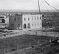
 Afula 1937
 -
 Workers housing, Afula 1946


State of Israel

Railroad (1948-49; 2010s)
Repairs to the
Terror attacks (1990s-2000s)
Due to Afula's proximity to the
2006 Lebanon War
On 17 July 2006, during the 2006 Lebanon War, Hezbollah fired Katyusha rockets at ʿAfula, one of the southernmost rocket attacks on Israel from Lebanon. Six people were treated for shock as a result of the attack. On 28 July, a rocket landed causing a fire. The rocket carried 100 kilograms (220 pounds) of explosives.[33]
Recent development plans
In September 2016, it was announced that seven new neighborhoods would be built, doubling the city's population.[34]
Notable incidents
In June 2018, 150 of the city's Jewish residents protested against the sale of a home to an Arab family. Former Afula Mayor Avi Elkabetz joined the protest and said, "the residents of Afula don't want a mixed city, but rather a Jewish city, and it's their right. This is not racism."[35]
In June 2019, a demonstration happened in protest against a house being sold to an Arab family, joined by Afula's mayor, Avi Elkabetz, who had run for office on a platform of "preserving the Jewish character of Afula."[36]
Climate
Afula has a mediterranean climate (Köppen climate classification: Csa). The average annual temperature is 20.4 °C (68.7 °F), and around 468 mm (18.43 in) of precipitation falls annually.
| Climate data for Afula | |||||||||||||
|---|---|---|---|---|---|---|---|---|---|---|---|---|---|
| Month | Jan | Feb | Mar | Apr | May | Jun | Jul | Aug | Sep | Oct | Nov | Dec | Year |
| Mean daily maximum °C (°F) | 17.2 (63.0) |
18.3 (64.9) |
21.5 (70.7) |
25.5 (77.9) |
29.8 (85.6) |
32.3 (90.1) |
34.1 (93.4) |
34.2 (93.6) |
32.9 (91.2) |
30.2 (86.4) |
25.0 (77.0) |
19.5 (67.1) |
26.7 (80.1) |
| Mean daily minimum °C (°F) | 5.6 (42.1) |
5.7 (42.3) |
7.2 (45.0) |
10.2 (50.4) |
14.1 (57.4) |
18.1 (64.6) |
21.3 (70.3) |
21.6 (70.9) |
19.3 (66.7) |
15.6 (60.1) |
10.4 (50.7) |
7.3 (45.1) |
13.0 (55.5) |
| Average rainfall mm (inches) | 110.4 (4.35) |
96.6 (3.80) |
54.9 (2.16) |
15.8 (0.62) |
4.5 (0.18) |
0.8 (0.03) |
0.0 (0.0) |
0.0 (0.0) |
0.7 (0.03) |
19.5 (0.77) |
61.2 (2.41) |
101.4 (3.99) |
465.8 (18.34) |
| Average rainy days (≥ 0.1 mm) | 11.7 | 10.6 | 7.8 | 3.1 | 1.1 | 0.1 | 0.0 | 0.0 | 0.3 | 3.1 | 6.6 | 10.0 | 54.4 |
| Source: World Meteorological Organization (temperature 1995–2009, rainfall and rain days 1981–2010)[37] | |||||||||||||
Economy


The Alon Tavor Industrial Zone is located northeast of Afula off
Education and culture


According to CBS, there are 24 schools and 8,688 students in the city: 16 elementary schools with a student population of 3,814 and 12 high schools with 4,874 students. 52.3% of 12th grade students were entitled to a matriculation certificate in 2001.
Health care
Archaeology

The ancient mound of ʿAfula, known as Tell ʿAfula, is close to the city center, west of Route 60 and south of Ussishkin Street. Very little of the initial six-acre tell remains due to construction work done in this area since the
The first excavations at Tell ʿAfula, carried out in 1948, found Late Chalcolithic–Early Bronze Age remains. Tombs from the Early Bronze Age, Middle Bronze Age II, Late Bronze Age–Iron Age I and Roman period were discovered near the municipal water tower. Archaeologists discovered the Crusader-Mamluk fortress on the southern peak of the tell, a Byzantine olive oil press and evidence of an Early Bronze Age settlement near the northern peak.[41]
In 1950–1951, excavations on the northwestern slope of the peak revealed a pottery workshop for Tell el-Yahudiyeh Ware from Middle Bronze Age II and another pottery workshop from Middle Bronze Age I.[41]
From the 1990s, several small excavations unearthed an uninterrupted sequence of settlement remains from the Chalcolithic until the Late Byzantine periods as well as remains from the Mamluk period.[42]
In 2012, excavations were conducted by the
Sports
The city's basketball club, Hapoel Afula, currently play in the Liga Leumit. The main football club, Hapoel Afula, won Liga Alef in the 2012–13 season and is currently playing at Liga Leumit.
Twin towns
Notable people
- Dalal Abu Amneh (born 1983), singer, producer, and research doctor in brain sciences
- Mosh Ben-Ari (born 1970), musician, lyricist and composer
- Amir Blumenfeld (born 1983), writer, comedian, actor, and television host
- Yaakov Bodo (born 1931), actor and comedian
- Dina Doron (born 1940), actress
- Sarit Hadad (born 1978), singer
- Eden Kartsev (born 2000), football player
- David Kushnir (born 1931), Olympic long-jumper
- Hila Lulu Linn(born 1964), artist
- Nikol Reznikov (born 1999), model and Miss Universe Israel 2018
- Samuel Scheimann (born 1987), football player
- Dagan Yivzori (born 1985), basketball player
- Vini Vici (Matan Kadosh & Aviram Saharai) (born 1983 & 1985), DJ/Producer
References
- ^ a b "Regional Statistics". Israel Central Bureau of Statistics. Retrieved 21 March 2024.
- ^ "Oops, Something is wrong".
- ^ a b "Afulah - Encyclopaedia Judaica | HighBeam Research". 28 March 2015. Archived from the original on 28 March 2015.
- ^ Palmer, 1881, p. 142
- ^ a b c Pringle, 1997, p. 18
- ^ ISSN 1565-5334. Retrieved 27 July 2020.
- ^ a b Conder and Kitchener, 1882, SWP II, p. 40
- ^ Vilnay, Zev (1938). "שמות של ישובים עברים על יסוד השמות הערבים" [Names of Hebrew settlements based on the Arab names]. www.nli.org.il (in Hebrew). Retrieved 16 February 2022.
- ^ Yoram Tsafrir, Leah Di Segni and Judith Green (1994). Tabula Imperii Romani: Judaea, Palaestina. Jerusalem: Israel Academy of Sciences and Humanities. p. 67.
- ^ Conder, 1876, p. 196
- ^ Conder and Kitchener, 1882, SWP II, p. 41
- ^ Karmon, 1960, p. 167 Archived 2019-12-22 at the Wayback Machine.
- ^ Buckingham, 1822, vol 2, p. 381
- ^ Robinson and Smith, 1841, vol 3, pp. 163, 181
- ^ NB note that ruined villages were marked with a star in the village lists, however neither Afulah of Al Fuleh were marked with that, see: Robinson and Smith, 1841, vol 3, 2nd appendix, p. 132
- ^ Thomson, 1859, vol 2, p. 216
- ^ Guérin, 1880, pp. 109-110
- ^ Schumacher, 1888, p. 183
- ^ Schumacher, 1900, p. 358
- ^ Barron, 1923, Table XI, Sub-district of Nazareth, p. 38
- ^ Barron, 1923, Table XVI, p. 50
- ^ a b Segev, 1999, p. 242
- ^ 130 families, according to List of villages sold by Sursocks and their partners to the Zionists since British occupation of Palestine, evidence to the Shaw Commission, 1930
- ISBN 0-930395-07-7p.114
- ^ Mills, 1932, p. 73
- ^ Government of Palestine, Department of Statistics, 1945, p. 8
- ^ Government of Palestine, Department of Statistics. Village Statistics, April, 1945. Quoted in Hadawi, 970, p. 62
- ^ Government of Palestine, Department of Statistics. Village Statistics, April, 1945. Quoted in Hadawi, 1970, p. 109
- ^ Government of Palestine, Department of Statistics. Village Statistics, April, 1945. Quoted in Hadawi, 1970, p. 159
- ^ Hilley, Yonathan (October 16, 2016). "The Wheels of History: Valley Railway Returns After 64 Years" [גלגלי ההיסטוריה: אחרי 64 שנים, רכבת העמק שבה לפעילות] (in Hebrew). Maariv. Retrieved October 16, 2016.
- ^ "Five die in latest suicide bombing; British bomber dead"
- ^ Arab Kills Female Israeli Soldier With Ax, The Washington Post, 1 December 1994
- ^ "Hezbollah Missiles With 100kg Warhead Strike Jezreel Valley". Haaretz.
- ^ "Afula to Double in Size - Hamodia.com". Hamodia. 14 September 2016.
- ^ "Hundreds of Israelis Demonstrate Against Home Sale to Arab Family". Haaretz. 14 June 2018.
- ^ "Afula mayor attends demonstration against sale of home to Arab family". Times of Israel. 16 June 2019.
- ^ "World Weather Information Service – Afula". World Meteorological Organization. Retrieved 12 November 2022.
- ^ Company Overview of Tadiran Air Conditioners Ltd.
- ^ Afula community guide
- ^ "Archived copy" (PDF). Archived from the original (PDF) on 14 April 2014. Retrieved 13 April 2014.
{{cite web}}: CS1 maint: archived copy as title (link) - ^ a b c Feig, 2012, Tel Afula final report Archived 2013-05-18 at the Wayback Machine
- ^ Dalali-Amos, 2008, ‘Afula Final Report
Bibliography
- Barag, Dan (1979). "A new source concerning the ultimate borders of the Latin Kingdom of Jerusalem". Israel Exploration Journal. 29: 197–217.
- Bron, Hendrik (28 August 2013). "'Afula Final Report" (125). Hadashot Arkheologiyot – Excavations and Surveys in Israel.
{{cite journal}}: Cite journal requires|journal=(help) - Buckingham, J.S. (1822). Travels in Palestine through the countries of Bashan and Gilead, east of the River Jordan, including a visit to the cities of Geraza and Gamala in the Decapolis. Vol. 2. London: Longman, Hurst, Rees, Orme and Brown.
- .
- Conder, C.R.; Kitchener, H.H. (1882). The Survey of Western Palestine: Memoirs of the Topography, Orography, Hydrography, and Archaeology. Vol. 2. London: Committee of the Palestine Exploration Fund.
- Dalali-Amos, Edna (17 December 2008). "'Afula" (121). Hadashot Arkheologiyot – Excavations and Surveys in Israel.
{{cite journal}}: Cite journal requires|journal=(help) - Dalali-Amos, Edna (15 October 2012). "'Afula" (124). Hadashot Arkheologiyot – Excavations and Surveys in Israel.
{{cite journal}}: Cite journal requires|journal=(help) - Dalali-Amos, Edna (16 February 2014). "'Afula Final Report" (126). Hadashot Arkheologiyot – Excavations and Surveys in Israel.
{{cite journal}}: Cite journal requires|journal=(help) - Dalali-Amos, Edna; Getzov, Nimrod (31 August 2014). "'Afula Preliminary Report" (126). Hadashot Arkheologiyot – Excavations and Surveys in Israel.
{{cite journal}}: Cite journal requires|journal=(help) - Eisenberg, Michael (14 December 2006). "'Afula, Tel" (118). Hadashot Arkheologiyot – Excavations and Surveys in Israel.
{{cite journal}}: Cite journal requires|journal=(help) - Feig, Nurit (4 November 2012). "'Afula, Tel Final Report" (124). Hadashot Arkheologiyot – Excavations and Surveys in Israel.
{{cite journal}}: Cite journal requires|journal=(help) - Glass, Joseph B. (2002). From new Zion to old Zion : American Jewish immigration and settlement in Palestine, 1917 - 1939. Wayne State University Press. ISBN 0814328423.
- Government of Palestine, Department of Statistics (1945). Village Statistics, April, 1945.
- Guérin, V. (1880). Description Géographique Historique et Archéologique de la Palestine (in French). Vol. 3: Galilee, pt. 1. Paris: L'Imprimerie Nationale.
- Hadawi, S. (1970). Village Statistics of 1945: A Classification of Land and Area ownership in Palestine. Palestine Liberation Organization Research Center. Archived from the original on 8 December 2018. Retrieved 9 February 2015.
- Karmon, Y. (1960). "An Analysis of Jacotin's Map of Palestine" (PDF). Israel Exploration Journal. 10 (3, 4): 155–173, 244–253. Archived from the original (PDF) on 22 December 2019. Retrieved 23 April 2015.
- Mills, E., ed. (1932). Census of Palestine 1931. Population of Villages, Towns and Administrative Areas. Jerusalem: Government of Palestine.
- Palmer, E.H. (1881). The Survey of Western Palestine: Arabic and English Name Lists Collected During the Survey by Lieutenants Conder and Kitchener, R. E. Transliterated and Explained by E.H. Palmer. Committee of the Palestine Exploration Fund.
- ISBN 0521-46010-7.
- Robinson, E.; Smith, E. (1841). Biblical Researches in Palestine, Mount Sinai and Arabia Petraea: A Journal of Travels in the year 1838. Vol. 3. Boston: Crocker & Brewster.
- Schumacher, G. (1888). "Population list of the Liwa of Akka". Quarterly Statement - Palestine Exploration Fund. 20: 169–191.
- .
- ISBN 978-0-349-11286-2.
- Thomson, W.M. (1859). The Land and the Book: Or, Biblical Illustrations Drawn from the Manners and Customs, the Scenes and Scenery, of the Holy Land. Vol. 2 (1 ed.). New York: Harper & brothers.
- Zevulun, U., "Tell el-Yahudiyeh Juglets from a Potter’s Refuse Pit at Afula", Eretz-Israel21 (1990), pp. 174–190, p. 107.
External links
- Afula municipal website
- Central Bureau of Statistics, Afula
- Survey of Western Palestine, Map 8: IAA, Wikimedia commons
- Afula municipal website on russian lang/
- Air-photo of Afula with index, 1946 - Eran Laor Cartographic Collection, The National Library of Israel
.svg)
| International | |
|---|---|
| National | |
| Geographic | |