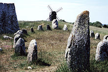
Agricultural landscape of southern Öland
| UNESCO World Heritage Site | |
|---|---|
 | |
| Location | Mörbylånga Municipality, Öland, Sweden |
| Criteria | Cultural: (iv), (v) |
| Reference | 968 |
| Inscription | 2000 (24th Session) |
| Area | 56,323 ha (217.46 sq mi) |
| Buffer zone | 6,069 ha (23.43 sq mi) |
| Coordinates | 56°28′00″N 16°33′00″E / 56.46667°N 16.55°E |
The agricultural landscape of southern Öland (
high pH
levels, it presents a wide range of plants, including many rare species.
The agricultural landscape of southern Öland was designated as a World Heritage Site by UNESCO in 2000, for the extraordinary biodiversity in this place, and its prehistory as well as the way how man has adapted to the natural conditions.[1]
Geological origins
The limestone plain was created by glacial action before the Ice Age. The limestone itself was formed about 500 million years ago from the sea to the south. It gradually hardened to become limestone and drifted north. Thus, the limestone of Stora alvaret contains a rich fossil record of some marine creatures that contribute, such Orthoceras found in some geomorphological structures on the island.[2]
Prehistory

The most famous
Viking
settlements appeared in the periphery.
References
- ^ UNESCO World Heritage Centre (ed.). "Agricultural Landscape of Southern Öland". World Heritage List. Retrieved 19 April 2017.
- ^ Thorsten Jansson, Stora Alvaret, Lenanders Tryckeri, Kalmar, 1999
- ^ K. Borg, U. Näsman, E. Wegraeus, "The Excavation of the Eketorp ring-fort 1964-74," a and Settlement Fortifikation Eketorp on Öland, Sweden 1976

