
Ahlat
Ahlat | |
|---|---|
 A panoramic view of Ahlat. | |
 Ahlat Location in Turkey | |
| Coordinates: 38°45′10″N 42°29′40″E / 38.75278°N 42.49444°E | |
| Country | Turkey |
| Province | Bitlis |
| District | Ahlat |
| Government | |
| • Mayor | Abdulalim Mümtaz Çoban (AKP) |
| Elevation | 1,650 m (5,410 ft) |
| Population (2021) | 27,563 |
| Time zone | UTC+3 (TRT) |
| Postal code | 13400 |
| Website | www |
Ahlat (Kurdish: Xelat;[1] Armenian: Խլաթ, romanized: Khlat[2]) is a town in Turkey's Bitlis Province in Eastern Anatolia Region. It is the seat of Ahlat District.[3] The town had a population of 27,563 in 2021.[4]
The town of Ahlat is situated on the northwestern shore of Lake Van. The mayor is Abdulalim Mümtaz Çoban (AKP).
History
Ahlat, known by its Armenian name of Khlat or Chliat in the ancient and medieval period, was once a part of the district of
After the
With the decline of the Seljuks, and the new political upheaval presented by the invasions of the

In the early 16th century, the
During the Circassian genocide, several Circassian refugees from the North Caucasus were settled in Ahlat district and established a few villages.[13]
As part of the
Modern day
Ahlat and its surroundings are known for a large number of historic
In recent years, Ahlat also came to be known for the quality of its
Tourism
The touristic places in Ahlat are
Demographics
In 1891 the kaza had 23,659 inhabitants: 16,635 Muslims; 6,609 Armenians; and 415 others. The city was then almost abandoned with only 200 houses on the eve of the First World War, including 15 Armenian houses.[19] The city includes Kurds of the Bekiran tribe and Karapapakhs.[20][21]
| Turkish | Arabic | Kurdish |
Circassian | Armenian | Unknown or other languages |
|---|---|---|---|---|---|
| 3,646 | – | 4,088 | 209 | – | 13 |
| Muslim | Armenian | Jewish | Other Christian |
|---|---|---|---|
| 7,959 | – | – | – |
Gallery
-
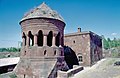 Ahlat Bayindir kümbet
 -
 Ahlat Bayindir kümbet and mosque
 -
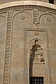
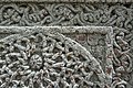
 Ahlat Bayindir kümbet Detail
 -
 Ahlat Hasan Padişah Kümbeti
 -
 Ahlat Hasan Padişah Kümbeti details
 -
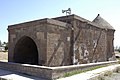
 Ahlat Kümbet
 -
 Ahlat Kümbet Ulu Kümbet
 -
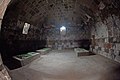 Ahlat Kümbet Interior
 -
 Ahlat Kümbet
 -
 Ahlat Museum Catafalque
 -
 Ahlat Museum Script
 -
 Ahlat Museum Animal with script
 -
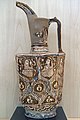 Ahlat Museum Water jug
 -
 Ahlat Gravestones
 -
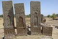 Ahlat Gravestones
 -
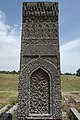 Ahlat Gravestone
 -
 Ahlat gravestone Detail
 -
 Ahlat Gravestone
 -
 Ahlat Gravestone
 -
 Ahlat Gravestone
 -
 Ahlat Gravestone
 -
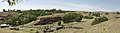 Ahlat Panorama
 -
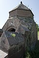
 The tower of the medieval Muslim cemetery of Ulu Kümbet.


Climate
Ahlat has a dry-summer humid continental climate (Köppen: Dsa),[23] with very warm, dry summers and cold, snowy winters.[24]
| Climate data for Ahlat (1991–2020) | |||||||||||||
|---|---|---|---|---|---|---|---|---|---|---|---|---|---|
| Month | Jan | Feb | Mar | Apr | May | Jun | Jul | Aug | Sep | Oct | Nov | Dec | Year |
| Mean daily maximum °C (°F) | 1.4 (34.5) |
2.0 (35.6) |
5.8 (42.4) |
11.5 (52.7) |
17.4 (63.3) |
23.8 (74.8) |
28.3 (82.9) |
28.9 (84.0) |
24.1 (75.4) |
17.0 (62.6) |
9.3 (48.7) |
3.7 (38.7) |
14.5 (58.1) |
| Daily mean °C (°F) | −2.3 (27.9) |
−1.9 (28.6) |
1.8 (35.2) |
7.1 (44.8) |
12.3 (54.1) |
17.9 (64.2) |
22.1 (71.8) |
22.5 (72.5) |
17.7 (63.9) |
11.6 (52.9) |
4.8 (40.6) |
0.0 (32.0) |
9.5 (49.1) |
| Mean daily minimum °C (°F) | −5.6 (21.9) |
−5.5 (22.1) |
−1.9 (28.6) |
3.0 (37.4) |
7.3 (45.1) |
11.6 (52.9) |
15.4 (59.7) |
16.0 (60.8) |
11.6 (52.9) |
6.9 (44.4) |
1.1 (34.0) |
−3.1 (26.4) |
4.8 (40.6) |
| Average precipitation mm (inches) | 40.05 (1.58) |
44.99 (1.77) |
60.27 (2.37) |
81.94 (3.23) |
59.47 (2.34) |
19.11 (0.75) |
5.79 (0.23) |
3.5 (0.14) |
13.45 (0.53) |
52.75 (2.08) |
54.6 (2.15) |
46.86 (1.84) |
482.78 (19.01) |
| Average precipitation days (≥ 1.0 mm) | 6.9 | 7.8 | 9.6 | 10.8 | 9.3 | 3.2 | 1.9 | 1.6 | 2.3 | 7.0 | 6.5 | 7.1 | 74.0 |
| Average relative humidity (%)
|
75.0 | 74.9 | 72.1 | 67.7 | 62.3 | 51.8 | 46.2 | 44.4 | 49.1 | 62.9 | 69.5 | 74.8 | 62.5 |
| Source: NOAA[25] | |||||||||||||
Notable people
- Şêx Şemsedînê Exlatî (1588–1674), Kurdish Sufi, poet and Sheikh
See also
- Ahlatshahs
- Cave dwellings of Ahlat
- The Tombstones of Ahlat the Urartian and Ottoman citadel
References
- ^ Adem, Avcıkıran (2009). Kürtçe Anamnez Anamneza bi Kurmancî (in Turkish and Kurdish). p. 55.
- ^ a b c d e f g h i j k l m n o p q r s t u v Bosworth & Crane 1984, pp. 725–727.
- ^ İlçe Belediyesi, Turkey Civil Administration Departments Inventory. Retrieved 30 January 2023.
- TÜİK. Retrieved 30 January 2023.
- ^ Lecker 2016.
- ^ Ter-Ghewondyan, Aram N. The Arab Emirates in Bagratid Armenia. Trans. Nina G. Garsoïan. Lisbon: Calouste Gulbenkian Foundation, 1976, pp. 32, 144.
- ^ Ter-Ghewondyan, ''The Arab Emirates in Bagratid Armenia, pp. 113, 139.
- ^ "Collusion of Herve Phrangopoulos with Turks of Samouch collapsed: Franks killed or captured at Chliat". Prosography of the Byzantine World. Retrieved 23 April 2022.
- ^ "The Safar-nama of Nasir Khusraw: Akhlat". Institute of Ismaili Studies. 2014. Retrieved 9 December 2018.
- ^ Lordkipanidze, Mariam; B. Hewitt, George (1987). Georgia in the XI-XII Centuries. Ganatleba Publishers. p. 41.
- ^ a b Floor 2008, p. 140.
- ^ Boyar 2013, p. 120.
- ^ Chochiev, Georgi; Koç, Bekir (2006). "Some Notes on the Settlement of Northern Caucasians in Eastern Anatolia and Their Adaptation Problems (the Second Half of the XIXth Century - the Beginning of the XXth Century)". Journal of Asian History. 40 (1): 89.
- ^ Üngör 2012, p. 111.
- ^ Ozoglu 2012, p. 61.
- ^ Yüksel Oktay. "On the Roads of Anatolia - Van". Los Angeles Chronicle. Archived from the original on 2007-09-28.
- ^ "Tentative World Heritage Sites". UNESCO.
- ^ "Türkiye'nin en kaliteli patatesi Ahlat'ta (Turkey's best quality potatoes are in Ahlat". Kenthaber Association of Local Newspapers of Turkey. Archived from the original on January 10, 2008.
- ^ "Kaza Ahlat / Akhlat / Խլաթ - Khlat". Virtual Genocide Memorial. Retrieved 2023-09-17.
- ^ Bekiran, Mehmet Fatih (2018). Bekiran Aşireti Tarihi (in Turkish). Berikan Yayınları. p. 219.
- ^ Yılmaz, Salih (2007). Türkiye ve Kafkasya'da yaşayan Karapapak (Terekeme) Türkleri tarihi ve kültürü (in Turkish). Ankara. p. 59.
{{cite book}}: CS1 maint: location missing publisher (link) - ^ .
- ^ "Table 1 Overview of the Köppen-Geiger climate classes including the defining criteria". Nature: Scientific Data.
- ^ "Kar Örtülü Gün Sayısı" (PDF). MGM.
- ^ "World Meteorological Organization Climate Normals for 1991-2020 — Ahlat". National Oceanic and Atmospheric Administration. Retrieved January 13, 2024.
Sources
- ISBN 978-0-71009-096-6.
- Boyar, Ebru (2013). "Ottoman expansion in the East". In ISBN 978-0-521-62094-9.
- Floor, Willem M. (2008). Titles and Emoluments in Safavid Iran: A Third Manual of Safavid Administration, by Mirza Naqi Nasiri. Washington, DC: Mage Publishers. ISBN 978-1933823232.
- Ozoglu, Hakan (2012), Kurdish Notables and the Ottoman State: Evolving Identities, Competing Loyalties, and Shifting Boundaries, ISBN 9780791485569
- Lecker, Michael (2016). "Ḥabīb b. Maslama al-Fihrī". In Fleet, Kate; ISSN 1873-9830.
- Üngör, Ugur Ümit (March 2012), The Making of Modern Turkey: Nation and State in Eastern Anatolia, 1913-1950, OUP Oxford (published 2012), ISBN 9780199655229
Further reading
- ISSN 1873-9830.
External links
| International | |
|---|---|
| National | |
| Other | |