
Aiga-i-le-Tai
Aiga-i-le-Tai | ||
|---|---|---|
District | ||
Country | ||
| Population (2016) | ||
| • Total | 5,029 | |
| Time zone | -11 | |
Aiga-i-le-Tai is a
The district includes part of the mainland at the western end of Upolu and surrounds an
Historically, Manono island has been the centre of the district. In modern times, the main centre is Mulifanua where the inter-island ferry terminal is located for ocean crossings between Savai'i and Upolu.
With an area of only 27 km², Aiga-i-le-Tai is the smallest electoral district
The words
Chief titles
Historically, the naval power of Manono and Apolima played a major role in political power-struggles between the national clans.
One of the most important chiefly (
Mulifanua ferry terminal
Today, the ferry terminal at
Archaeology
Gallery
- Aiga-i-le-Tai
-
 Visitor onNu'ulopaisland.
 -
 Apolima island.
 -
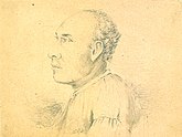 Amatai, war chief Matetau of Manono Island, drawn by Alfred Thomas Agate(1812-1846)
 -
 Faleo'o beach fale on Manono island.
 -
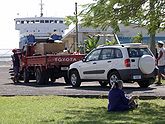 Cars wait to board the ferry at Mulifanua.


Electoral results
| Party | Candidate | Votes | % | ±% | |
|---|---|---|---|---|---|
| FAST | Laki Mulipola Leiataua | 1,343 | 39.1 | ||
| HRPP | Leiataualesā Taupau Mulipola Oliva | 831 | 24.2 | -6.4 | |
| HRPP | Ifopo Matia Filisi Jahnke | 727 | 21.2 | -3.0 | |
| HRPP | Mulipola Atonio Patua Mulipola | 328 | 9.6 | ||
| HRPP | Pouli Taialofa Naseri | 205 | 6.0 | ||
| FAST gain from Independent | Swing | New | |||
References
- ^ "Population and Housing Census Report 2006" (PDF). Samoa Bureau of Statistics. July 2008. Archived from the original (PDF) on 21 July 2011. Retrieved 18 December 2009.
- ^ "Samoa Territorial Constituencies Act 1963". Pacific Islands Legal Information Institute. Archived from the original on 5 June 2011. Retrieved 15 December 2009.
- ^ Augustin Krämer. The Samoa Islands: An Outline of a Monograph With Particular Consideration of German Samoa. University of Hawaii Press. p. 55.
- ^ Journal of the Polynesian Society: New Information For The Ferry Berth Site, Mulifanua, Western Samoa, By H. M. Leach, P 319-330 New Information for the Ferry Berth Site, Mulifanua, Western Samoa by Roger C. Green & Helen M. Leach, Journal of the Polynesian Society, Vol. 98, No. 3, 1989. Retrieved 23 April 2010
- ^ [1] Temper sands in prehistoric Oceanian pottery: geotectonics, sedimentology, petrography, provenance by William R. Dickinson, p.34.Retrieved 23 April 2010
13°52′S 172°4′W / 13.867°S 172.067°W
Traditional centre: Manono Island | ||
| Villages |  | |
| Islands |
| |
| Transportation |
| |
| Archaeology of Samoa |
| |
| Environment | ||
| Electoral constituency: Faipule District |
| |
| ||
| Authority control databases: Geographic |
|---|