
Ajloun Governorate
Ajloun Governorate
محافظة عجلون | |
|---|---|
 The city of Ajloun is the capital of Ajloun Governorate | |
 Ajloun Governorate in Jordan | |
| Country | Jordan |
| Capital | Ajloun |
| Subdivisions | Ajloun Department, Kofranjah Department |
| Government | |
| • Governor | Ali Azzam |
| Area | |
| • Total | 420 km2 (160 sq mi) |
| Population (2012) | |
| • Total | 146,900 |
| • Density | 350/km2 (910/sq mi) |
| Time zone | GMT +2 |
| • Summer (DST) | +3 |
| Urban | 75.9% |
| Rural | 24.1% |
| HDI (2021) | 0.714[1] high · 6th of 12 |
Ajloun Governorate (alternative spelling Ajlun Governorate) (
Administrative divisions
Article 14 of the Administrative Divisions System of the Ministry of Interior divides Ajloun Governorate into two departments.
- Capital Department: includes 50 towns and villages, with its administrative center in Ajloun.
- Kofranjah Department: includes 19 towns and villages, its administrative center is in Kofranjah.
History
During the
Along with Balqa and Karak governorates, Ajloun was formerly a united sanjak of the Ottoman Empire.[2]
Climate
Ajloun is known for its high elevation, which makes it one of the coolest cities in Jordan, with an average maximum temperature during January of 8.2 degrees Celsius, and a minimum average temperature of 2.8 degrees Celsius. Snow is common during the winter.
Demographics
The population of districts according to census results:[3]
| District | Population (Census 1994) |
Population (Census 2004) |
Population (Census 2015) |
|---|---|---|---|
| Ajloun Governorate | 94,548 | 118,725 | 176,080 |
| Kufranjah | 20,809 | 27,107 | 38,260 |
| Qaṣabah 'Ajlūn | 73,739 | 91,618 | 137,820 |
Economy
The governorate depends mainly on agriculture. In 2008, olive, grape and fruit farms constituted a total area of 141.4 km2 which is 34% of the area of Ajloun Governorate.[4]
Education
There are 28 primary and secondary schools in Ajloun, most of them being public institutions, such as Ajloun University College (a public college) and Ajloun National University, a small private university.
Major villages
Notable towns and villages in Ajloun (other than Ajloun self) include Ibbeen (Ebeen), Sakhra, Mrajjam, Rasoun, Rajeb, Ain Janna, Kufranji, Anjara and Al Hashimiyya.
Gallery
-
 The town of Al Hashimiyya in Ajloun Governorate
 -
 The town of Al Wahadinah
 -
 Forests surround Ajloun
 -
 Nahias of Ajloun
 -
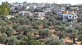 Olive farms in a village in Ajloun


References
- ^ "Sub-national HDI - Area Database - Global Data Lab". hdi.globaldatalab.org. Retrieved 2018-09-13.
- ^ a b "Ajloun Governorate". moi.gov.jo. Retrieved 2022-10-01.
- ^ "Jordan: Administrative Division, Governorates and Districts". citypopulation.de. Retrieved 25 December 2016.
- ^ "Ministry of Agriculture - Jordan (Arabic)". moa.gov.jo. Archived from the original on 2012-03-03. Retrieved 2012-05-14.
Places adjacent to Ajloun Governorate | ||||||||||||||||
|---|---|---|---|---|---|---|---|---|---|---|---|---|---|---|---|---|
| ||||||||||||||||
| North Region | ||
|---|---|---|
| Central Region | ||
| South Region | ||

This Jordanian location article is a stub. You can help Wikipedia by expanding it. |