
Alūksne
This article needs additional citations for verification. (April 2012) |
Alūksne | |
|---|---|
Town | |
 | |
|
UTC+3 (EEST) | |
| Postal code | LV-430(1-2) |
| Calling code | +371 643 |
| Climate | Dfb |
| Website | visitaluksne |
Alūksne (
History

The region around Lake Alūksne was originally settled by Finnic-speaking tribes, and from the 8th-12th centuries by Latgalians. The date of settlement at the current location of the town, then known as Olysta, Alyst, and Volyst, is given in the chronicles of Pskov as 1284. The later name "Alūksne" comes from the Latgalian word olūksna, meaning a spring in the forest.[citation needed]
The Latgalian inhabitants of the settlement were conquered by the
Marienburg was captured by the troops of

During the
The town's island is known as Pils salas (Castle Island) and Maria Island.
Nature
Alūksne lake
Alūksne is located on the shore of Lake Alūksne, which is the eleventh largest lake in Latvia. There are four islands in the lake - Cepurītes or Love Island, Long Island, Tīklu Island and Castle Island. The average depth of the lake is about 7 meters. The deepest place reaches up to 20 meters.
Climate
Alūksne has a humid continental climate (Köppen Dfb).
| Climate data for Alūksne, Latvia (1991-2020 normals, extremes 1945-present) | |||||||||||||
|---|---|---|---|---|---|---|---|---|---|---|---|---|---|
| Month | Jan | Feb | Mar | Apr | May | Jun | Jul | Aug | Sep | Oct | Nov | Dec | Year |
| Record high °C (°F) | 8.8 (47.8) |
10.9 (51.6) |
18.2 (64.8) |
26.5 (79.7) |
30.2 (86.4) |
32.0 (89.6) |
33.3 (91.9) |
32.9 (91.2) |
29.4 (84.9) |
21.1 (70.0) |
13.1 (55.6) |
10.8 (51.4) |
33.3 (91.9) |
| Mean daily maximum °C (°F) | −2.8 (27.0) |
−2.4 (27.7) |
2.5 (36.5) |
10.2 (50.4) |
16.4 (61.5) |
19.9 (67.8) |
22.4 (72.3) |
20.9 (69.6) |
15.3 (59.5) |
8.2 (46.8) |
2.3 (36.1) |
−1.1 (30.0) |
9.3 (48.8) |
| Daily mean °C (°F) | −4.9 (23.2) |
−5.1 (22.8) |
−1.0 (30.2) |
5.6 (42.1) |
11.3 (52.3) |
15.0 (59.0) |
17.4 (63.3) |
16.1 (61.0) |
11.1 (52.0) |
5.3 (41.5) |
−0.4 (31.3) |
−3.0 (26.6) |
5.7 (42.3) |
| Mean daily minimum °C (°F) | −7.5 (18.5) |
−8.1 (17.4) |
−4.6 (23.7) |
0.8 (33.4) |
5.7 (42.3) |
9.9 (49.8) |
12.6 (54.7) |
11.6 (52.9) |
7.4 (45.3) |
2.6 (36.7) |
−1.6 (29.1) |
−5.1 (22.8) |
2.0 (35.6) |
| Record low °C (°F) | −37.4 (−35.3) |
−36.8 (−34.2) |
−28.8 (−19.8) |
−15.9 (3.4) |
−5.8 (21.6) |
−0.3 (31.5) |
2.9 (37.2) |
0.7 (33.3) |
−5.1 (22.8) |
−10.6 (12.9) |
−20.6 (−5.1) |
−36.8 (−34.2) |
−37.4 (−35.3) |
| Average precipitation mm (inches) | 55.4 (2.18) |
43.9 (1.73) |
40.8 (1.61) |
40.5 (1.59) |
63.1 (2.48) |
90.3 (3.56) |
82.9 (3.26) |
82.9 (3.26) |
63.7 (2.51) |
73.8 (2.91) |
61.0 (2.40) |
52.0 (2.05) |
750.3 (29.54) |
| Average precipitation days (≥ 1 mm) | 14 | 11 | 11 | 8 | 10 | 13 | 11 | 12 | 12 | 13 | 14 | 14 | 143 |
| Mean monthly sunshine hours | 30.9 | 60.2 | 133.3 | 199.0 | 278.4 | 273.1 | 284.2 | 243.1 | 151.7 | 73.5 | 28.3 | 20.5 | 1,776.2 |
| Percent possible sunshine | 14 | 24 | 37 | 47 | 55 | 52 | 54 | 53 | 41 | 24 | 12 | 10 | 41 |
| Source 1: LVĢMC[8][9] | |||||||||||||
| Source 2: NOAA (precipitation days 1981-2010)[10] | |||||||||||||
Demographics
Within existing limits, according to CSB data.
Graphs are unavailable due to technical issues. There is more info on Phabricator and on MediaWiki.org. |
|
| ||||||||||||||||||||||||||||||||||||
| Source: Latvian Geospatial Information Agency[11] | |||||||||||||||||||||||||||||||||||||
Notable people
- Rozālija Purgale (1904-1984), judge
- Dainis Dukurs (born 1957), skeleton coach
- Kristaps Lībietis (born 1982), biathlete
- Edgars Bertuks (born 1985), orienteering competitor
- Ilona Marhele (born 1986), long distance runner
- Andrejs Rastorgujevs (born 1988), biathlete
- Andris Vosekalns (born 1992), cyclist
Sister cities
Gallery
-
 Soldiers of the Latvian National Armed Forces in Alūksne in the 1930s
 -
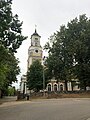 Lutheran church in Alūksne
 -
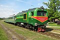 Narrow gauge railway in Alūksne
 -
 Alūksne town centre
 -

-

-
 Alūksne orthodox church
 -
 Alūksne Art School
 -
 Alūksne cemetery
 -
 Alūksne Castle ruins


.JPG)


References
- ^ "Reģionu, novadu, pilsētu un pagastu kopējā un sauszemes platība gada sākumā". Central Statistical Bureau of Latvia. Retrieved 18 January 2023.
- ^ "Iedzīvotāju skaits pēc tautības reģionos, pilsētās, novados, pagastos, apkaimēs un blīvi apdzīvotās teritorijās gada sākumā (pēc administratīvi teritoriālās reformas 2021. gadā) 2021 - 2022". Central Statistical Bureau of Latvia. Retrieved 3 October 2023.
- ^ Rene Levoll: "The last motor race of the empire (ee: Impeeriumi viimane motovõistlus, de: Das letzte Autorennen des Imperiums)", Tallinn 2014, Estonian Old Technics Museum Foundation, page 81 "list of former and present place names of places"
- ^ "Latvijas augstāko pilsētu TOP 20". neogeo.lv. 2010-05-24. Retrieved 2014-12-18.
- ^ "Alūksnes vēsture". VisitAluksne (in Latvian). Retrieved 2022-01-02.
- ^ "Livonian Order Castle Ruins in Alūksne". Latvia.travel. Retrieved 14 July 2022.
- ^ Освобождение городов
- ^ "Klimatisko normu dati". Latvian Environment, Geology and Meteorology Centre. Retrieved January 12, 2023.
- ^ "Gaisa temperatūras rekordi". Latvian Environment, Geology and Meteorology Centre. Retrieved January 12, 2023.
- ^ "World Meteorological Organization Climate Normals for 1981-2010". National Oceanic and Atmospheric Administration. Retrieved January 12, 2023.
- ^ CSD data
- ^ "International Relations". joniskis.lt. Retrieved 29 April 2014.
External links
| International | |
|---|---|
| National | |