
Al-Bahah Province
This article relies largely or entirely on a single source. (September 2014) |
Al-Bahah
Al-Bāḥah ٱلْبَاحَة | ||
|---|---|---|
Capital Al-Bahah | | |
| Manatiq (Districts) | 7 | |
| Government | ||
| • Governor | Hussam bin Saud Al Saud | |
| Area | ||
| • Total | 9,921 km2 (3,831 sq mi) | |
| Population (2017 census) | ||
| • Total | 476,172 | |
| • Density | 48/km2 (120/sq mi) | |
| ISO 3166-2 | 11 | |
| Area code | +966 17 | |
| Website | www | |
Al-Bahah Province (
Etymology
The word al-Baḥah (or Baḥah without al which is equivalent to "the" in English) has many meanings; it means water[4] and the maximum of it, the courtyard of a house, the high and abundant palm tree. In tales it refers to an extremely deep bottomless well in al-Zafir fortress. It means "open space", "water" and "abundant palm tree" and the "midline of a road".
Governors
- Saud bin Abdulrahman bin Turki Al Sudairi (1962–1977)
- Ibrahim bin Abdulaziz Al Ibrahim (1977–1987)
- Muhammed bin Saud Al Saud (1987–2010)
- Mishari bin Saud bin Abdulaziz Al Saud(28 August 2010 – 22 April 2017)
- Hussam bin Saud bin Abdulaziz Al Saud(22 April 2017 – present)
Geography

Al-Baḥah is the name of the province as well its main city, situated in the northwestern part of Ghamed territory. The region is formed of
Major cities
- Al Bahah
- Baljurashi
- Al-Mandaq
- Al-Mikhwah
- Al-Aqeeq
Topography

The region is divided by huge rocky steeps into two main sectors. To the west is a coastal plain, the Tihamah. To the east is the mountain range of al-As-Sarawat or the Sarat, with an elevation of 1,500 to 2,450 m (4,920 to 8,040 ft) above sea level.
Population
A genealogist[
Al-Azad is an Arab tribe which is divided into 24 tribes derived from four stocks: Azad Shenou`a, Azad Al Sarat, Azad Ghassan and Azad Aman. Al-Azad (or al-Assad the
Climate
The variation in topography influences the climate of the region. Al-Sarat area is exposed to the formation of clouds and fog, and this often happens in winter because of air masses coming from the Red Sea, accompanied by thunderstorms. In spring and summer the climate is mild and pleasant. The climate in the area of the Tihamah is different from that in Al-Sarat, although they are separated by no more than 25 km (16 miles). The Tihama is an undulating coastal plain, hot in summer, warm in spring and mild in winter. The climate in general falls in the arid zone. Relative humidity varies between 52% and 67%, with maximum temperatures of 23 °C (73 °F), and minimum temperatures of 12 °C (54 °F).
Gallery
-
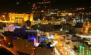 Al-Bahah City
 -
 Thee Ain historic village
 -
 Sarawat Mountains in Al-Bahah
 -
 Mount Shada
 -

-

-
 Awirah Village Fort
 -


.jpg)


Social structure
The social life of the inhabitants of the region is based on
Places adjacent to Al-Bahah Province | ||||||||||||||||
|---|---|---|---|---|---|---|---|---|---|---|---|---|---|---|---|---|
| ||||||||||||||||
See also
References
- ^ "Population Characteristics surveys" (PDF). The General Authority for Statistics. 2017.
- ^ "معلومات عامة عن مناطق المملكة العربية السعودية". General Authority of statistics. 25 February 2016.
- ISBN 978-1-9009-8840-7.
- ^ Team, Almaany. "تعريف و معنى باحة بالعربي في معجم المعاني الجامع، المعجم الوسيط ،اللغة العربية المعاصر - معجم عربي عربي - صفحة 1". www.almaany.com (in Arabic). Retrieved 22 November 2018.