
Al-Jura
al-Jura
الجورة | ||
|---|---|---|
 Part of the former village site, in 2015 | ||
| Etymology: the Hollow[1] | ||
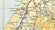
.jpg) 1870s map 1870s map .jpg) 1940s map 1940s map.jpg) modern map modern map .jpg) 1940s with modern overlay map 1940s with modern overlay mapA series of historical maps of the area around Al-Jura (click the buttons) | ||
Geopolitical entity Mandatory Palestine | | |
| Subdistrict | Gaza | |
| Date of depopulation | November 4–5, 1948[4] | |
| Area | ||
| • Total | 12,224 dunams (12.224 km2 or 4.720 sq mi) | |
| Population (1945) | ||
| • Total | 2,420[2][3] | |
| Cause(s) of depopulation | Military assault by Yishuv forces | |
| Current Localities | Ashkelon[5] | |
Al-Jura (
Its residents had their origins in Egypt, Hebron, and Bedouin communities.[6]
The Shrine of Husayn's Head was located outside the town, until it was destroyed by the Israeli army in 1950.
The founder and spiritual leader of the Hamas militant organization Ahmed Yassin was born in al-Jura.
History
Al-Jura (El-Jurah) stood northeast of and immediately adjacent to the mound of ancient and medieval Ascalon.
Byzantine ceramics have been found here, together with coins dating to the seventh century CE.[7]
Ottoman era
In the first Ottoman
Marom and Taxel have shown that during the seventeenth to eighteenth centuries, nomadic economic and security pressures led to settlement abandonment around Majdal ‘Asqalān, and the southern coastal plain in general. The population of abandoned villages moved to surviving settlements, while the lands of abandoned settlements continued to be cultivated by neighboring villages. Thus, al-Jura absorbed the lands of al-Rasm and al-Bira, the last one separated from the village by the lands of al-Majdal.[8]
The Syrian
In 1838, Edward Robinson noted el-Jurah as a Muslim village, located in the Gaza district.[11]
In 1863 the French explorer Victor Guérin visited the village, which he called Djoura, and found it to have three hundred inhabitants. He further noted that he could see numerous antiquities, taken from the ruined city, and that the inhabitants of the village grew handsome fruit trees, as well as flowers and vegetables.[12] An Ottoman village list from about 1870 found that the village had a population of 340, in a total of 109 houses, though the population count included men, only.[13][14]
In the late nineteenth century, the village of Al-Jura was situated on flat ground bordering on the ruins of ancient Ascalon.[15] It was rectangular in shape and the residents were Muslim. They had a mosque and a school which was founded in 1919.[10]
British Mandate era
-
 Al-Jura, 1931 (1:200,000)
 -
 Al-Jura, 1945 (1:250,000)


In the
In the 1945 statistics El Jura had a population of 2,420 Muslims,[2] with a total of 12,224 dunams of land, according to an official land and population survey.[3] Of this, 481 dunams were used for citrus and bananas, 7,192 for plantations and irrigable land, 2,965 for cereals,[18] while 45 dunams were built-up land.[19]
By the 1940s the school had 206 students.[10]
1948 War
At the end of November 1948, Coastal Plain District troops carried out sweeps of the villages around and to the south of
In 1992, the village site was described: "Only one of the village houses has been spared; thorny plants grow on the parts of the site not built over by
Shrine of Husayn's Head

The
It was considered the most
Notable residents
See also
- Depopulated Palestinian locations in Israel
References
- ^ Palmer, 1881, p. 360
- ^ a b Department of Statistics, 1945, p. 31
- ^ a b c Government of Palestine, Department of Statistics. Village Statistics, April, 1945. Quoted in Hadawi, 1970, p. 46
- ^ Morris, 2004, p. xix, village #307, Also gives the cause for depopulation
- ^ a b Khalidi, 1992, p. 117
- ^ Grossman, D. (1986). "Oscillations in the Rural Settlement of Samaria and Judaea in the Ottoman Period". in Shomron studies. Dar, S., Safrai, S., (eds). Tel Aviv: Hakibbutz Hameuchad Publishing House. p. 383
- ^ Dauphin, 1998, p. 872
- ^ ISSN 0305-7488.
- ^ Hütteroth and Abdulfattah, 1977, p. 150. Quoted in Khalidi, 1992, p. 116
- ^ a b c Khalidi, 1992, p. 116.
- ^ Robinson and Smith, vol 3, 2nd appendix, p. 118
- ^ Guérin, 1869, p. 134
- Askalon
- ^ Hartmann, 1883, p. 130, also noted 109 houses
- ^ Conder and Kitchener, 1883, SWP III, p. 236. Quoted in Khalidi, 1992, p. 116
- ^ Barron, 1923, Table V, Sub-district of Gaza, p. 8
- ^ Mills, 1932, p. 4
- ^ Government of Palestine, Department of Statistics. Village Statistics, April, 1945. Quoted in Hadawi, 1970, p. 87
- ^ Government of Palestine, Department of Statistics. Village Statistics, April, 1945. Quoted in Hadawi, 1970, p. 137
- ^ Coastal Plain District HQ to battalions 151 and ´1 Volunteers`, etc., 19:55 hours, 25 Nov. 1948, IDFA (=Israeli Defence Forces and Defence Ministry Archive) 6308\49\\141. Cited in Morris, 2004, p. 517
- ^ Coastal Plain HQ to Southern Front\Operations, 30 Nov. 1948, IDFA 1978\50\\1; and Southern Front\Operations to General Staff Divisions, 2. Dec. 1948, IDFA 922\75\\1025. Cited in Morris, 2004, p. 518
- ^ Press, Michael (March 2014). "Hussein's Head and Importance of Cultural Heritage". The Ancient Near East Today. American School of Oriental Research. Archived from the original on 17 May 2020. Retrieved 17 May 2020.
- ^ Talmon-Heller 2020, p. 101–111.
- ^ a b Talmon-Heller, Kedar & Reiter 2016.
- ^ Petersen 2017, pp. 108–110.
- ^ Petersen 2017, p. 108.
- ^ The life and death of Shaikh Yasin Al Jazeera
Bibliography
- Barron, J.B., ed. (1923). Palestine: Report and General Abstracts of the Census of 1922. Government of Palestine.
- Conder, C.R.; Kitchener, H.H. (1883). The Survey of Western Palestine: Memoirs of the Topography, Orography, Hydrography, and Archaeology. Vol. 3. London: Committee of the Palestine Exploration Fund.
- ISBN 0-860549-05-4.
- Department of Statistics (1945). Village Statistics, April, 1945. Government of Palestine.
- Guérin, V. (1869). Description Géographique Historique et Archéologique de la Palestine (in French). Vol. 1: Judee, pt. 2. Paris: L'Imprimerie Nationale. (p146: refer to Stanhope visit 1815, III, 152-169) 25 May
- Hadawi, S. (1970). Village Statistics of 1945: A Classification of Land and Area ownership in Palestine. Palestine Liberation Organization Research Center. Archived from the original on 2018-12-08. Retrieved 2009-10-04.
- Hartmann, M. (1883). "Die Ortschaftenliste des Liwa Jerusalem in dem türkischen Staatskalender für Syrien auf das Jahr 1288 der Flucht (1871)". Zeitschrift des Deutschen Palästina-Vereins. 6: 102–149.
- Hütteroth, Wolf-Dieter; Abdulfattah, Kamal (1977). Historical Geography of Palestine, Transjordan and Southern Syria in the Late 16th Century. Erlanger Geographische Arbeiten, Sonderband 5. Erlangen, Germany: Vorstand der Fränkischen Geographischen Gesellschaft. ISBN 3-920405-41-2.
- ISBN 0-88728-224-5.
- Kogan-Zehavi, Elena (2006-08-02). "Ashqelon, el-Jura". Hadashot Arkheologiyot – Excavations and Surveys in Israel (118).
- Kogan-Zehavi, Elena (2011-09-26). "Ashqelon, el-Jura". Hadashot Arkheologiyot – Excavations and Surveys in Israel (123).
- Mills, E., ed. (1932). Census of Palestine 1931. Population of Villages, Towns and Administrative Areas. Jerusalem: Government of Palestine.
- ISBN 978-0-521-00967-6.
- Palmer, E.H. (1881). The Survey of Western Palestine: Arabic and English Name Lists Collected During the Survey by Lieutenants Conder and Kitchener, R. E. Transliterated and Explained by E.H. Palmer. Committee of the Palestine Exploration Fund.
- Peretz, Ilan; Eisenberg-Degen, Davida (2017-12-18). "Ashqelon, el-Jura". Hadashot Arkheologiyot – Excavations and Surveys in Israel (129).
- Petersen, A. (2017). "Shrine of Husayn's Head". Bones of Contention: Muslim Shrines in Palestine. Heritage Studies in the Muslim World. Springer Singapore. ISBN 978-981-10-6965-9. Retrieved 2023-01-06.
- Robinson, E.; Smith, E. (1841). Biblical Researches in Palestine, Mount Sinai and Arabia Petraea: A Journal of Travels in the year 1838. Vol. 3. Boston: Crocker & Brewster.
- Socin, A. (1879). "Alphabetisches Verzeichniss von Ortschaften des Paschalik Jerusalem". Zeitschrift des Deutschen Palästina-Vereins. 2: 135–163.
- Talmon-Heller, Daniella; ISSN 1613-0928.
- Talmon-Heller, Daniella (2020). "Part I: A Sacred Place: The Shrine of al-Husayn's Head". Sacred Place and Sacred Time in the Medieval Islamic Middle East: An Historical Perspective. University Press Scholarship Online. S2CID 240874864.
External links
- Al-Jura Town Statistics and Facts
- al-Jura (Gaza), Zochrot
- Survey of Western Palestine, Map 19: IAA, Wikimedia commons
- Jura from the Khalil Sakakini Cultural Center

| International | |
|---|---|
| National | |