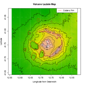
Alban Hills
| Alban Hills | |
|---|---|
| Colli Albani | |
Alban Lake | |
| Highest point | |
| Peak | Maschio delle Faete |
| Elevation | 956 m (3,136 ft) |
| Coordinates | 41°43′48″N 12°42′00″E / 41.73000°N 12.70000°E |
| Geography | |
| Geology | |
| Mountain type | Stratovolcano |
| Last eruption | 5,000 BC |
The Alban Hills (
History
The hills, especially around the shores of the lakes, have been popular since prehistoric times. From the 9th to 7th century BC, there were numerous villages (see the legendary
The ancient
In Roman times, the area was often used by the rich as a way to escape the heat and crowds of Rome, as it is today as shown by the many villas and country houses present.
Towns and cities
The towns and villages in the Alban Hills are known as the
Volcanic activity


Examination of deposits have dated the four most recent eruptions to two temporal peaks, around 36,000 and 39,000 years ago.[2][3] The area exhibits small localised earthquake swarms, bradyseism, and release of carbon dioxide and hydrogen sulfide into the atmosphere. The uplift and earthquake swarms have been interpreted as caused by a slowly growing spherical magma chamber 5-6 kilometres below the surface;[4] some think that it may erupt again; if so, there is risk to Rome, which is only 25 to 30 km away.[5][6]
There is documentary evidence which may describe an eruption in 114 BC, but the absence of
The volcano emits large amounts of
People

Writers and artists who have produced work about this area include:
- Thomas Ashby, archaeologist, wrote The Roman Campagna in Classic Time
- William Brockedon painter and illustrator of guide-books
- George Gordon Byron in Childe Harold's Pilgrimage
- Charles Coleman painter
- Johann Wolfgang von Goethe in Italian Journey
- Louis Gurlitt, German painter
- Jacob Philipp Hackert, German painter
- Gavin Hamilton, artist and antiquarian, painter and archaeologist, in Genzanoand Lanuvio (18th century)
- James Duffield Harding in Tourist in Italy
- John Henry Henshall watercolor painter
- Richard Colt Hoarein A classical tour through Italy and Sicily
- Ellis Cornelia Knight, writer and painter in Description of Latium or La Campagna di Roma
- Edward Lear painter and lithographer
- William Leighton Leitch watercolor painter in Lanuvio
- Charles H. Poingdestre painter
- John Singer Sargent, painter in Villa Torlonia - Frascati
- Stendhal, writer, in Albano Laziale, Chroniques italiennes (1836–1839): L'Abbesse de Castro
- J. M. W. Turner, RA, British painter
- Georgina E. Troutbeck, Rambles in Rome - London - ed. Mills & Boon - 1914
- Richard Voss, German dramatist and novelist
- Clara Louisa Wells in The Alban Hills ed. 1878
Panorama
See also
References
- ^ One or more of the preceding sentences incorporates text from a publication now in the public domain: Chisholm, Hugh, ed. (1911). "Albanus Mons". Encyclopædia Britannica. Vol. 1 (11th ed.). Cambridge University Press. p. 487.
- ^
Freda, Carmela; et al. (2006). "Eruptive history and petrologic evolution of the Albano multiple maar (Alban Hills, Central Italy)". Bulletin of Volcanology. 68 (6): 567–591. S2CID 128473558. Retrieved 2019-05-17.
- S2CID 128956849.
- ^ a b Behncke, Boris (2003). "Italy's Volcanoes: The Cradle of Volcanology". Archived from the original on 13 February 2006.
- .
- ^ Carapezza, M. L.; Barberi, F.; Tarchini, L.; Ranaldi, M.; Ricci, T. (2010). "Volcanic hazards of the Colli Albani". In Funiciello, R.; Giordano, G. (eds.). The Colli Albani Volcano. Special Publications of IAVCEI #3. London: Geological Society. pp. 279–297.
- S2CID 128647166.
- ^ "Occupational Health Guideline for Carbon Dioxide" (PDF). National Institute for Occupational Safety and Health, United States Center for Disease Control. 1975. Archived (PDF) from the original on 7 June 2009.
- .
External links


