Altınözü
Altınözü | |
|---|---|
District and municipality | |
 | |
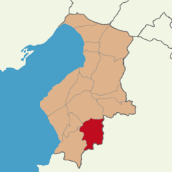
 Map showing Altınözü District in Hatay Province | |
| Coordinates: 36°06′0″N 36°13′48″E / 36.10000°N 36.23000°E | |
| Country | Turkey |
| Province | Hatay |
| Government | |
| • Mayor | Rıfat Sarı (AKP) |
| Area | 392 km2 (151 sq mi) |
| Elevation | 400 m (1,300 ft) |
| Population (2022)[1] | 60,344 |
| • Density | 150/km2 (400/sq mi) |
| Time zone | UTC+3 (TRT) |
| Postal code | 31750 |
| Area code | 0326 |
| Website | www |
Altınözü (
Arabic: الْقُصَيْر, el-Kusayr) is a municipality and district of Hatay Province, Turkey.[2] Its area is 392 km2,[3] and its population is 60,344 (2022).[1] It is in the south-east of Hatay Province, on the border between Turkey and Syria. The mayor is Rıfat Sarı (AKP
).
History
The region which was known as al-Quṣayr,King Baldwin IV sent a delegation to settle the dispute.[6]
Altınözü was heavily damaged by
powerful earthquakes in February 2023 and subsequent aftershocks.[7]
Geography
Altınözü stands on the fertile Kuseyr plateau, and several crops such as
olives (the largest olive growing area is in this part of Turkey), tobacco
, grains and other crops are grown here. The district gets its water from the Yarseli reservoir.
Composition
There are 48
neighbourhoods in Altınözü District:[8]
- Akamber
- Akdarı
- Alakent
- Altınkaya
- Atayurdu
- Avuttepe
- Babatorun
- Boynuyoğun
- Büyükburç
- Çetenli
- Dokuzdal
- Enek
- Erbaşı
- Fatikli
- Gözecik
- Günvuran
- Hacıpaşa
- Hanyolu
- Kamberli
- Kansu
- Karbeyaz
- Karsu
- Kazancık
- Keskincik
- Kılıçtutan
- Kıyıgören
- Kolcular
- Kozkalesi
- Kurtmezraası
- Mayadalı
- Oymaklı
- Sarıbük
- Sarılar
- Seferli
- Sivrikavak
- Sofular
- Tepehan
- Tokaçlı
- Tokdemir
- Toprakhisar
- Türkmenmezraası
- Yanıkpınar
- Yarseli
- Yenihisar
- Yenişehir
- Yolağzı
- Yunushanı
- Ziyaret
Demographics
The district has a population of 60,344 (2022).Rûm Orthodox) Christian community encompassing two churches in the capital of the district and the entirely Christian village of Tokaçlı.
Notes
References
- ^ TÜİK. Retrieved 19 September 2023.
- ^ Büyükşehir İlçe Belediyesi, Turkey Civil Administration Departments Inventory. Retrieved 19 September 2023.
- ^ "İl ve İlçe Yüz ölçümleri". General Directorate of Mapping. Retrieved 19 September 2023.
- ^ a b Hamilton 2000, p. 165.
- ^ Runciman 1989, p. 429.
- ^ Buck 2017, p. 51.
- ^ "Hatay'da ağır yıkımın bilançosu..." [The result of the heavy destruction in Hatay...] (in Turkish). Iskenderun.org. 2023-04-08.
- ^ Mahalle, Turkey Civil Administration Departments Inventory. Retrieved 19 September 2023.
- ^ Syrian refugees in Turkey: Will they ever go home?
Sources
- Buck, Andrew D. (2017). The Principality of Antioch and Its Frontiers in the Twelfth Century. Boydell Press. ISBN 9781783271733.
- Hamilton, Bernard (2000). The Leper King and His Heirs: Baldwin IV and the Crusader Kingdom of Jerusalem. Cambridge University Press. ISBN 978-0-521-64187-6.
- ISBN 0-521-06163-6.
External links
- (in Turkish) local information, follow galeri for photos

