
Altaussee
Altaussee
Oid Aussee | ||
|---|---|---|
 | ||
|
Postal code 8992 | ||
| Area code | 03622 | |
| Vehicle registration | LI | |
| Website | Official website | |

Altaussee (German:
Geography
The municipality is located in the small Ausseerland-Region within the Styrian part of the
Nearby towns are
.Local geology
The characteristic pale grey mountains which surround Altaussee are made of
Tectonics: a major tectonic fault line runs directly beneath the Lake Altaussee, approximately east–west, and terminates in the valley west of the Seewiese. The fault is seismically active, with small earthquakes common. On a hot, clear day in August 1998, a small earthquake on the fault (M=3) caught summer bathers by surprise with a low, rumbling sound and, a few minutes later, unusually high waves.
Evaporites: Large evaporite reserves are present in the Sandling mountain, formed as a result of a major period of marine lowstand, when the sea level was low and the sea dried out. Panning and surface-level drift mining of the deposits dates back to Roman times, thanks to evidence from archaeological excavations in the 1990s, followed by similar local works from 200-400 AD.[4] By 1147 the mines had become a commercial venture, controlled by the Rein Abbey near Graz. In 1211 the mines were nationalised by Leopold VI, Duke of Austria, who transferred control to Unterlupitsch. With operations later transferred to Bad Aussee, investment in 1319 allowed the opening of the Steinberg tunnel. Followed by further periods on investment, by 1334, the mines were operated under license by the private Hallinger Union who employed 120 people, producing about 10,000 tonnes of product per annum. Renationalised by Frederick III in 1445, 120 people produced circa 10,00 tonnes of product per annum until the early 20th century. In 1906, a new brine pipeline through the Rettenbach Valley to Bad Ischl to supply the Solvay Works located in the market town of Ebensee. It is for this reason that Altaussee, and other local towns and villages such as Hallstatt, are now part of the Salzkammergut region. Production volumes in the following years quadruple, and employees double to 238.
By 1938, the salt mine had come to the attention of Adolf Hitler. Located close to his intended museum complex in Linz, inside the mine the conditions were constant: between 40 and 47 degrees; about 65 percent humidity; with the deepest tunnels more than a mile inside the mountain, safe from enemy bombs. The Nazi's built floors, walls, and shelving as well as a workshop deep in the chambers.[5]
Post-war after recovery of the art, brine production resumed. The mines are still operational today, and brine is pumped to the market town of Ebensee. In 2008, 61 employees produced 1,506,000m³ of brine, with a salt content of 450,000 tons. It is for this reason that Altaussee, and other local towns and villages such as Hallstatt, are now part of the Salzkammergut region.
History

The oldest settlement on the ground of the modern village of Altaussee dates back to the Roman rule (200-400 AD).[4] However, there is no historical continuity of a settlement before the Middle Ages. The salt mine on the ground of the modern village was first documented in 1147 AD, the village itself in 1265.[6]
Around 1250
In 1848 manorialism was abolished in the cisleithanian part of the Austrian Empire and Altaussee became an autonomous political municipality.
In the 19th century Altaussee evolved into a popular summer-resort. Especially writers and intellectuals, for example Hugo von Hofmannsthal, Jakob Wassermann, Theodor Herzl and Friedrich Torberg, spent their summer holidays in the small alpine village.[9]
World War II

After the annexation of Austria into the
As of spring 1944, there was a permanent shelter for Wehrmacht deserters, draft dodgers and resisters hidden in the rough terrain of the Totes Gebirge north of the village. This hideout called Igel (hedgehog), was provided with food by trusted third parties in the population.[14] At the end of the war the Igel sheltered 35 people.[15]
The Ausseerland region was part of the so-called
On 8 May 1945 a reconnaissance squadron of the
In the two great wars of the 20th Century, a total of 162 citizens of Altaussee fell as soldiers (44 in World War I and 118 in World War II).[27]
On 1 July 1948 the village became part of the Austrian state Styria again. Until 1955 Altaussee was part of the American occupation zone in Austria.
Nazi repository for stolen art

During World War II (1943–1945) the extensive complex of salt mines in Altaussee served as a huge repository for art stolen by the Nazis. These artworks were accumulated under the alias
Leisure and Sport
| Altaussee (Station Bad Aussee, 4 km distance) | ||||||||||||||||||||||||||||||||||||||||||||||||||||||||||||
|---|---|---|---|---|---|---|---|---|---|---|---|---|---|---|---|---|---|---|---|---|---|---|---|---|---|---|---|---|---|---|---|---|---|---|---|---|---|---|---|---|---|---|---|---|---|---|---|---|---|---|---|---|---|---|---|---|---|---|---|---|
| Climate chart (explanation) | ||||||||||||||||||||||||||||||||||||||||||||||||||||||||||||
| ||||||||||||||||||||||||||||||||||||||||||||||||||||||||||||
| ||||||||||||||||||||||||||||||||||||||||||||||||||||||||||||
A 7.5 km trail goes around the clear Lake Altaussee surrounded by 1838 m high Loser mountain the Trisslwand, the Tressenstein and other mountain ranges. Brown and white alpine-style houses with a beautiful church are in the center of town. The tourist bureau has a few English pamphlets, but most information, including the Literatur museum inside, is in German. A saltmine tour through the Altaussee saltmine and the former Nazi Stolen Art Repository is available every hour in the summer.[29] Hiking trails abound, with various gradings. They are marked with green and white signs. The lower ones are easy to follow while the more difficult routes are sometimes less well-marked. A paradise for outdoor enthusiasts and hikers. Flora and waterfalls make the forests and mountains even more attractive in the summer. The 9 km-long Loser Panorama Road leads to a perfect base (1.600 m) for hikes into the heart of the Tote Gebirge Mountain Range.[30] From where the road ends it is only an hours walk to the Loser Peak (1.838 m). In the wintertime the ski resort of Loser offers 29 km slopes with all levels of difficulty. In addition there are other nearby ski resorts available.
-
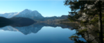
 The Lake Altaussee and the Trisselwand Mountain
 -
 Lake Altaussee
 -
 View of the Lake Altaussee and Altaussee, in the background the Hoher Dachstein
 -
 Loser Panorama Road, in the background the Hoher Dachstein


Notable people
- Karin Brandauer (1945–1992), Austrian film director and screenwriter.
- Klaus Maria Brandauer (born 1943), Austrian actor, film director, and professor at the Max Reinhardt Seminar in Vienna; lives in Altaussee and Vienna.
- Marianne Feldhammer (1909–1996), Austrian resistance fighter against Nazism.
- Barbara Frischmuth (born 1941), Austrian writer of poetry and prose.
- Joseph Fröhlich (1694–1757), court jester of Augustus II the Strong.
- Michael Moser (1853–1912), Austrian photographer.
- Hermann Markus Pressl (1939–1994), Austrian composer and music teacher.
- Paul Preuss (1886–1913), Austrian alpinist.
- Jakob Wassermann (1873-1934), German-Jewish writer.
See also
References
- ^ "Dauersiedlungsraum der Gemeinden Politischen Bezirke und Bundesländer - Gebietsstand 1.1.2018". Statistics Austria. Retrieved 10 March 2019.
- ^ "Einwohnerzahl 1.1.2018 nach Gemeinden mit Status, Gebietsstand 1.1.2018". Statistics Austria. Retrieved 9 March 2019.
- ^ "ZAMG Klimagutachten". Archived from the original on 2011-09-07. Retrieved 2012-07-18.
- ^ ISBN 3-901370-226, p. 103.
- ^ Morrison, Jim. "The True Story of the Monuments Men". Smithsonianmag.com. Retrieved 20 December 2021.
- ^ Cf. Karl Vocelka: Die Haus- und Hofnamen der Katastralgemeinden Altaussee, Grundlsee, Lupitsch, Obertressen, Reitern und Straßen im steirischen Salzkammergut. Band 2 (= Dissertationen der Universität Wien 102). Verband der wissenschaftlichen Gesellschaften Österreichs, Wien 1974, p. 500.
- ISBN 3-222-12613-5
- ^ Karl Vocelka: Die Haus- und Hofnamen der Katastralgemeinden Altaussee, Grundlsee, Lupitsch, Obertressen, Reitern und Strassen im Steirischen Salzkammergut. Band 1 (= Dissertationen der Universität Wien 102). Verband der wissenschaftlichen Gesellschaften Österreichs, Wien 1974, p. 19f.
- ISBN 3-222-12613-5
- ^ Erika Selzer, ed. (1996), 1945. Ende und Anfang im Ausseer Land. Katalog zur Ausstellung im Ausseer Kammerhofmuseum Mai 1995 - Mai 1996 (in German), vol. 17, Bad Aussee, p. 11
{{citation}}: CS1 maint: location missing publisher (link) - ^ Erika Selzer, ed. (1996), 1945. Ende und Anfang im Ausseer Land. Katalog zur Ausstellung im Ausseer Kammerhofmuseum Mai 1995 - Mai 1996 (in German), vol. 17, Bad Aussee, p. 19
{{citation}}: CS1 maint: location missing publisher (link) - ^ "Central Intelligence Agency: The Last Days of Ernst Kaltenbrunner. Approved for release CIA historical review programm, 22. Sept 1993". Archived from the original on January 9, 2008. Retrieved 2012-07-19.
- ISBN 978-1-5555-3273-4
- ^ Erika Selzer, ed. (1996), 1945. Ende und Anfang im Ausseer Land. Katalog zur Ausstellung im Ausseer Kammerhofmuseum Mai 1995 - Mai 1996 (in German), vol. 17, Bad Aussee, pp. 33f
{{citation}}: CS1 maint: location missing publisher (link) - ^ Helmut Kalss, Widerstand im Salzkammergut-Ausseerland (in German), Altaussee: Eigenverlag, p. 96
- ISBN 3-222-12613-5
- ^ a b c Erika Selzer, ed. (1996), 1945. Ende und Anfang im Ausseer Land. Katalog zur Ausstellung im Ausseer Kammerhofmuseum Mai 1995 - Mai 1996 (in German), vol. 17, Bad Aussee, p. 25
{{citation}}: CS1 maint: location missing publisher (link) - ISSN 0042-5702
- ^ Erika Selzer, ed. (1996), 1945. Ende und Anfang im Ausseer Land. Katalog zur Ausstellung im Ausseer Kammerhofmuseum Mai 1995 - Mai 1996 (in German), vol. 17, Bad Aussee, p. 89
{{citation}}: CS1 maint: location missing publisher (link) - ^ "Simon Wiesenthal: Doch die Mörder leben. Auf der Jagd nach flüchtigen NS-Verbrechern. In: Der Spiegel (35/1967)". Der Spiegel. 20 August 1967. Retrieved 2012-08-07.
- ISBN 978-0-7679-2873-1, S. 10.
- ^ "Simon Wiesenthal Archiv: Some significant cases: Adolf Eichmann". Archived from the original on 2011-09-16. Retrieved 2012-07-19.
- ISBN 978-0-7679-2873-1, S. 22.
- ^ "Wider des Vergessens. Index der Täter: Burger, Anton (in German)". Archived from the original on 2015-06-11. Retrieved 2013-03-13.
- ^ Erika Selzer, ed. (1996), 1945. Ende und Anfang im Ausseer Land. Katalog zur Ausstellung im Ausseer Kammerhofmuseum Mai 1995 - Mai 1996 (in German), vol. 17, Bad Aussee, p. 49
{{citation}}: CS1 maint: location missing publisher (link) - ^ "Bundesministerium für Vermögenssicherung und Wirtschaftsplanung. Fahndungsabteilung: Erhebungen über ehem. Goldbestände im Ausseerland. Bericht, Zahl 47115/2/47. Wien, 29. September 1947" (PDF). Archived from the original (PDF; 9,9 MB) on 2012-09-16. Retrieved 2012-07-19.
- ^ Numbers of the fallen citizens according to the death roll of the Altaussee war memorial.
- ^ "Altaussee Salt Mines: During World War II, Austria's oldest salt mine was used to store thousands of pieces of stolen artwork". Atlas Obscura - Places. Atlas Obscura. 4 May 2022. Retrieved 21 June 2022.
- ^ "Altaussee Salt Mine". Saltwelten.at. Retrieved 2014-05-27.
- ^ "Loser Panorama Road". Salzkammergut.at. Retrieved 2014-05-27.
External links
Places adjacent to Altaussee | ||||||||||||||||
|---|---|---|---|---|---|---|---|---|---|---|---|---|---|---|---|---|
| ||||||||||||||||
| International | |
|---|---|
| National | |