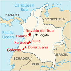
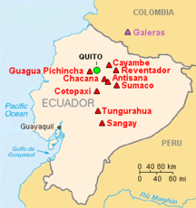
Andean Volcanic Belt

The Andean Volcanic Belt is a major
Romeral in Colombia is the northernmost active member of the Andean Volcanic Belt.[1] South of latitude 49° S within the Austral Volcanic Zone volcanic activity decreases with the southernmost volcano Fueguino in Tierra del Fuego archipelago.
Volcanic zones
The Andean Volcanic Belt is segmented into four main areas of active volcanism; the Northern, Central, Southern, and Austral volcanic zones, each of which is a separate continental volcanic arc.
Northern Volcanic Zone
The Northern Volcanic Zone (NVZ) extends from
The
Central Volcanic Zone
The Central Volcanic Zone (CVZ) is a volcanic arc in western South America. It is one of the four volcanic zones of the Andes. The Central Volcanic Zone extends from Peru to Chile and forms the western boundary of the Altiplano plateau. The volcanic arc has formed due to subduction of the Nazca Plate under western South America along the Peru–Chile Trench. To the south, the CVZ is limited by the Pampean flat-slab segment or Norte Chico flat-slab segment, a region devoid of volcanism due to a lower subduction angle caused by the subduction of Juan Fernández Ridge.
The CVZ is characterized by a
Southern Volcanic Zone
The South Volcanic Zone (SVZ) extends roughly from Central Chile's Andes at the latitude of
From north to south the Southern Volcanic Zone is divided into four segments according to the characteristics of the continental crust, volcanoes and volcanic rocks:[6]
- Northern SVZ (NSVZ; 33°S–34°30′S)
- Transitional SVZ (TSVZ; 34°30′S–37°S)
- Central SVZ (CSVZ; 37°S–41.5°S)
- Southern SVZ (SSVZ: 41.5°S–46°S)
In Central Southern Volcanic Zone and Southern Southern Volcanic Zone, magma ascent occur primarily by the Liquiñe-Ofqui Fault.[7]
The Principal Cordillera of Andes (east Santiago) rose in late Cenozoic and became extensively glaciated about one million years ago. This meant lavas from NSVZ volcanoes begun to be channeled along a network of glacial valleys ever since.[8] The Maipo caldera exploded about 450 thousand years ago, leaving behind copious amounts of ash and ignimbrite rock that can be observed today both in Chile and Argentina.[8]
During the
The magmas of modern (
Several volcanoes of the SVZ are being monitored by the Southern Andean Volcano Observatory (OVDAS) based in Temuco. The volcanoes monitored have varied over time but some like Villarrica and Llaima are monitored constantly. In recent years, there have been major eruptions at Chaitén (2008–2010), Cordón Caulle (2011) and Calbuco (2015).
Austral Volcanic Zone
The Austral Volcanic Zone (AVZ) is a volcanic arc in the Andes of southwestern South America. It is one of the four volcanic zones of the Andes. The AVZ extends south of the Patagonian Volcanic Gap to Tierra del Fuego archipelago, a distance of well over 600 mi (1,000 km). The arc has formed due to subduction of the Antarctic Plate under the South American Plate. Eruption products consist chiefly of alkaline basalt and basanite.[12] Volcanism in the Austral Volcanic Zone is less vigorous than in the Southern Volcanic Zone. Recorded eruptions are rare due to the area being unexplored well into the 19th century; the cloudy weather of its western coast might also have prevented sightings of eruptions. The Austral Volcanic Zone hosts both glaciated stratovolcanoes as well as subglacial volcanoes under the Southern Patagonian Ice Field.
Volcanic gaps
The different volcanic zones are intercalated by volcanic gaps, zones that, despite lying at the right distance from an oceanic trench, lack volcanic activity.[13] The Andes has three major volcanic gaps the Peruvian flat-slab segment (3 °S–15 °S), the Pampean flat-slab segment (27 °S–33 °S) and the Patagonian Volcanic Gap (46 °S–49 °S). The first one separates the Northern from the Central Volcanic Zone, the second the Central from the Southern and the last separates the Southern from the Austral Volcanic Zone. The Peruvian and Pampean gaps coincide with areas of flat slab (low angle) subduction and therefore the lack of volcanism is believed to be caused by the shallow dip of the subducting Nazca Plate in these places. The shallow dip has in turn been explained by the subduction of the Nazca Ridge and the Juan Fernández Ridge for the Peruvian and Pampean gaps respectively. Since the Nazca and Juan Fernández Ridge are created by volcanic activity in Pacific hotspots (Easter and Juan Fernández) it can be said that volcanic activity in the Pacific is responsible for the suppression of volcanism in parts of the Andes.
The Patagonian gap is different in nature as it is caused not by the subduction of an aseismic ridge but by the subduction of the
Peruvian gap
Between the latitudes of 3 °S–15 °S in Peru the last volcanic activity occurred 2.7 million years ago in Cordillera Blanca.[15] The lack of volcanism in central and northern Peru is widely attributed to a side effect of the flat-slab (low angle) subduction of the Nazca Plate occurring there. While the subduction of the Nazca Ridge has often been credited for causing this flat-slab and hence the lack of volcanism, many researchers find the gap too wide to be explained by this alone.
One hypothesis claims that the flat-slab is caused by the ongoing subduction of an oceanic plateau. This hypothetical plateau named Inca Plateau would be a mirror image of the Marquesas Plateau in the South Pacific.[15]
Pampean gap
The Pampean gap or Norte Chico separates the Andes Central and Southern volcanic zones. A low subduction angle caused by the subduction of Juan Fernández Ridge has been pointed out as causing or contributing to the suppression of volcanism.
Magma Path Distribution
The distribution of magma paths in a volcanic system are typically controlled by the regional tectonic activity. In a typical setting, the magma path is thought to be parallel to the maximum stress (either in compressional or extensional stress regimes). In the case of the Andes, the maximum stress is oriented in the East-West direction as the Nazca Plate is subducted underneath the South American Plate in the eastern direction. Recent studies conducted by Tibaldi et al. have discovered that the magma paths and dyke distribution in the Andean Volcanic Belt are not parallel to the maximum stress (E-W direction). Instead, the magma path generally follows a North-South/Northwest-Southeast trend in the Andes. [16] Tibaldi et al. concluded that the magma path distribution is actually controlled by pre-existing structures and crustal weaknesses in the crust rather than the regional stresses.
Back-arc volcanism
This section needs expansion. You can help by adding to it. (May 2010) |
Other significant back-arc volcanism regions include the
Geothermal activity
The Andean Volcanic Belt represents a large
See also
- List of volcanoes in Argentina
- List of volcanoes in Bolivia
- List of volcanoes in Chile
- List of volcanoes in Peru
References
- ^ "Romeral". Volcano.si.edu. 29 March 2012. Global Volcanism Program
- ^ ISSN 0716-0208.
- ^ "Home – Instituto Geofísico – EPN". igepn.edu.ec. Retrieved 11 September 2015.
- .
- ^ de Silva, S.L.; Francis, P.W. (1991). Volcanoes of the Central Andes. Berlin Heildelberg New York: Springer. p. 216.
- ^ López-Escobar, Leopoldo; Kilian, Rolf; Kempton, Pamela D.; Tagiri, Michio (1993). "Petrography and geochemistry of Quaternary rocks from the Southern Volcanic Zone of the Andes between 41 30'and 46 00'S, Chile". Revista Geológica de Chile. 20 (1): 33–55.
- .
- ^ . Retrieved 9 June 2019.
- ^ .
- ^ )
- .
- .
- .
- S2CID 129658687.
- ^ .
- ^ Tibaldi, A. "Structural control on volcanoes and magma paths from local- to orogen-scale: The central Andes case".
- hdl:11336/98912.
- ^ "Andean Volcanic Belt". 5 November 1997. Retrieved 19 July 2009.


