
Andes
| Andes Mountains | |
|---|---|
Quechua) | |
| Geography | |
 Map of South America showing the Andes running along the entire western part (roughly parallel to the Pacific coast) of the continent
| |
| Countries | |
| Range coordinates | 32°S 70°W / 32°S 70°W |
.jpg)

The Andes (
Along their length, the Andes are split into several ranges, separated by intermediate depressions. The Andes are the location of several high plateaus—some of which host major cities such as Quito, Bogotá, Cali, Arequipa, Medellín, Bucaramanga, Sucre, Mérida, El Alto and La Paz. The Altiplano Plateau is the world's second-highest after the Tibetan Plateau. These ranges are in turn grouped into three major divisions based on climate: the Tropical Andes, the Dry Andes, and the Wet Andes.
The Andes Mountains are the highest mountain range outside
The Andes are also part of the American Cordillera, a chain of mountain ranges (cordillera) that consists of an almost continuous sequence of mountain ranges that form the western "backbone" of the Americas and Antarctica.
Etymology
The etymology of the word Andes has been debated. The majority consensus is that it derives from the
The term cordillera comes from the Spanish word cordel 'rope'[2] and is used as a descriptive name for several contiguous sections of the Andes, as well as the entire Andean range, and the combined mountain chain along the western part of the North and South American continents.
Geography
%E2%80%93Valle_Carbajal_01.jpg)
The Andes can be divided into three sections:
- The Southern Andes
- in Argentina and Chile, south of Llullaillaco.
- The Central Andes
- in Peru and Bolivia.
- The Northern Andes
- in Venezuela, Colombia, and Ecuador. In the northern part of the Andes, the separate Sierra Nevada de Santa Marta range is often treated as part of the Northern Andes.[3]
The Leeward Antilles islands Aruba, Bonaire, and Curaçao, which lie in the Caribbean Sea off the coast of Venezuela, were formerly thought to represent the submerged peaks of the extreme northern edge of the Andes range, but ongoing geological studies indicate that such a simplification does not do justice to the complex tectonic boundary between the South American and Caribbean plates.[4]
Geology
| Geology of the Andes |
|---|
| Orogenies |
| Fold-thrust belts |
| Batholiths |
| Subducted structures |
|
| Faults |
| Andean Volcanic Belt |
| Pampean flat-slab |
| Terranes |
The Andes are a
The Andean orogen has a series of bends or
Orogeny
The western rim of the
The formation of the modern Andes began with the events of the Triassic when Pangaea began the break up that resulted in developing several rifts. The development continued through the Jurassic Period. It was during the Cretaceous Period that the Andes began to take their present form, by the uplifting, faulting and folding of sedimentary and metamorphic rocks of the ancient cratons to the east. The rise of the Andes has not been constant, as different regions have had different degrees of tectonic stress, uplift, and erosion.
Across the 1,000 km (620 mi) wide Drake Passage lie the mountains of the Antarctic Peninsula south of the Scotia Plate which appear to be a continuation of the Andes chain.
The far east regions of the Andes experience a series of changes resulting from the Andean orogeny. Parts of the
Seismic Activity
Tectonic forces above the
The amount, magnitude, and type of seismic activity varies greatly along the subduction zone. These differences are due to a wide range of factors, including friction between the plates, angle of subduction, buoyancy of the subducting plate, rate of subduction, and hydration value of the mantle material. The highest rate of seismic activity is observed in the central portion of the boundary, between 33°S and 35°S. In this area, the angle of subduction is very low, meaning the subducting plate is nearly horizontal. Studies of mantle hydration across the subduction zone have shown a correlation between increased material hydration and lower magnitude, more frequent seismic activity. Zones exhibiting dehydration instead are thought to have a higher potential for larger, high magnitude earthquakes in the future. [15]
In the extreme south, a major transform fault separates Tierra del Fuego from the small Scotia Plate.
Volcanism

The Andes range has many active volcanoes distributed in four volcanic zones separated by areas of inactivity. The Andean volcanism is a result of the
Ore deposits and evaporates
The Andes Mountains host large
History
The Andes Mountains, initially inhabited by
In the tide of
Climate and hydrology


The climate in the Andes varies greatly depending on latitude, altitude, and proximity to the sea. Temperature, atmospheric pressure and humidity decrease in higher elevations. The southern section is rainy and cool, the central section is dry. The northern Andes are typically rainy and warm, with an average temperature of 18 °C (64 °F) in Colombia. The climate is known to change drastically in rather short distances. Rainforests exist just kilometres away from the snow-covered peak of Cotopaxi. The mountains have a large effect on the temperatures of nearby areas. The snow line depends on the location. It is at between 4,500 and 4,800 m (14,764 and 15,748 ft) in the tropical Ecuadorian, Colombian, Venezuelan, and northern Peruvian Andes, rising to 4,800–5,200 m (15,748–17,060 ft) in the drier mountains of southern Peru south to northern Chile south to about 30°S before descending to 4,500 m (14,760 ft) on Aconcagua at 32°S, 2,000 m (6,600 ft) at 40°S, 500 m (1,640 ft) at 50°S, and only 300 m (980 ft) in Tierra del Fuego at 55°S; from 50°S, several of the larger glaciers descend to sea level.[17]
The Andes of Chile and Argentina can be divided into two climatic and glaciological zones: the Dry Andes and the Wet Andes. Since the Dry Andes extend from the latitudes of the Atacama Desert to the area of the Maule River, precipitation is more sporadic and there are strong temperature oscillations. The line of equilibrium may shift drastically over short periods of time, leaving a whole glacier in the ablation area or in the accumulation area.
In the high Andes of
Though precipitation increases with height, there are semiarid conditions in the nearly 7,000-metre (22,966 ft) highest mountains of the Andes. This dry steppe climate is considered to be typical of the subtropical position at 32–34° S. The valley bottoms have no woods, just dwarf scrub. The largest glaciers, for example, the Plomo Glacier and the Horcones Glaciers, do not even reach 10 km (6.2 mi) in length and have only insignificant ice thickness. At glacial times, however, c. 20,000 years ago, the glaciers were over ten times longer. On the east side of this section of the Mendozina Andes, they flowed down to 2,060 m (6,759 ft) and on the west side to about 1,220 m (4,003 ft) above sea level.[20][21] The massifs of Cerro Aconcagua (6,961 m (22,838 ft)), Cerro Tupungato (6,550 m (21,490 ft)) and Nevado Juncal (6,110 m (20,046 ft)) are tens of kilometres away from each other and were connected by a joint ice stream network. The Andes' dendritic glacier arms, i.e. components of valley glaciers, were up to 112.5 km (69.9 mi) long, over 1,250 m (4,101 ft) thick and overspanned a vertical distance of 5,150 m (16,896 ft). The climatic glacier snowline (ELA) was lowered from 4,600 m (15,092 ft) to 3,200 m (10,499 ft) at glacial times.[20][22][23][24][25][26][27][28][29]
Flora

The Andean region cuts across several
About 30,000 species of
Fauna

The Andes are rich in fauna: With almost 1,000 species, of which roughly 2/3 are endemic to the region, the Andes are the most important region in the world for amphibians.[31] The diversity of animals in the Andes is high, with almost 600 species of mammals (13% endemic), more than 1,700 species of birds (about 1/3 endemic), more than 600 species of reptile (about 45% endemic), and almost 400 species of fish (about 1/3 endemic).[31]
The
Birds of humid Andean forests include
A number of species such as the
Human activity
This section needs additional citations for verification. (January 2011) |
The Andes Mountains form a north–south axis of cultural influences. A long series of cultural development culminated in the expansion of the

Devastated by European diseases and by
surveyed a large part of the Bolivian Andes from 1826 to 1827.Cities
In modern times, the largest cities in the Andes are
La Paz, Bolivia's seat of government, is the highest capital city in the world, at an elevation of approximately 3,650 m (11,975 ft). Parts of the La Paz conurbation, including the city of El Alto, extend up to 4,200 m (13,780 ft).
Other cities in or near the Andes include
-
-
 Santiago de Chile
 -

-

-
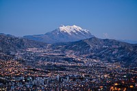
 View of Mérida, Venezuela

.JPG)


Transportation
Cities and large towns are connected with
The rough terrain has historically put the costs of building
However, there is one railroad that connects Chile with Peru via the Andes, and there are others that make the same connection via southern Bolivia. See railroad maps of that region.
There are multiple highways in Bolivia that cross the Andes. Some of these were built during a period of war between Bolivia and Paraguay, in order to transport Bolivian troops and their supplies to the war front in the lowlands of southeastern Bolivia and western Paraguay.
For decades, Chile claimed ownership of land on the eastern side of the Andes. However, these claims were given up in about 1870 during the
Because of the tortuous terrain in places, villages and towns in the mountains—to which travel via
Agriculture

The ancient peoples of the Andes such as the Incas have practiced irrigation techniques for over 6,000 years. Because of the mountain slopes, terracing has been a common practice. Terracing, however, was only extensively employed after Incan imperial expansions to fuel their expanding realm. The potato holds a very important role as an internally consumed staple crop. Maize was also an important crop for these people, and was used for the production of chicha, important to Andean native people. Currently, tobacco, cotton and coffee are the main export crops. Coca, despite eradication programmes in some countries, remains an important crop for legal local use in a mildly stimulating herbal tea, and, both controversially and illegally, for the production of cocaine.
Irrigation

In unirrigated land, pasture is the most common type of land use. In the rainy season (summer), part of the rangeland is used for cropping (mainly potatoes, barley, broad beans and wheat).
Irrigation is helpful in advancing the sowing data of the summer crops which guarantees an early yield in the period of food shortage. Also, by early sowing, maize can be cultivated higher up in the mountains (up to 3,800 m (12,500 ft)). In addition, it makes cropping in the dry season (winter) possible and allows the cultivation of frost-resistant vegetable crops like onion and carrot.[40]
Mining

The Andes rose to fame for their mineral wealth during the Spanish conquest of South America. Although Andean Amerindian peoples crafted ceremonial jewelry of gold and other metals, the mineralizations of the Andes were first mined on a large scale after the Spanish arrival. Potosí in present-day Bolivia and Cerro de Pasco in Peru were among the principal mines of the Spanish Empire in the New World. Río de la Plata and Argentina[41] derive their names from the silver of Potosí.
Currently, mining in the Andes of Chile and Peru places these countries as the first and second major producers of copper in the world. Peru also contains the 4th largest goldmine in the world: the Yanacocha. The Bolivian Andes produce principally tin although historically silver mining had a huge impact on the economy of 17th-century Europe.
There is a long history of mining in the Andes, from the Spanish silver mines in Potosí in the 16th century to the vast current porphyry copper deposits of Chuquicamata and Escondida in Chile and Toquepala in Peru. Other metals including iron, gold, and tin in addition to non-metallic resources are important. The Andes have a vast supply of lithium; Argentina, Bolivia, and Chile have the three largest reserves in the world respectively.[42]
Accion andina´s reforestation plan
Depending on the country, this species goes by different names. In Peru, it's known as queñual, queuña, or queñoa. In Bolivia, as kewiña. In Ecuador, as yagual; and in Argentina, tabaquillo. Regardless of the name, Polylepis is a high Andean genus encompassing up to 45 species of trees and shrubs distributed across the South American Andes, from Venezuela to Patagonia, found even up to 5,000 meters above sea level.[43]
Despite its limited recognition and only 5% of its native population remaining, the queñual, with its twisted trunks, has become the protagonist of an inspiring story to protect water in the region.[43]
In 2000, inspired by ancestral customs in communities of his native Cusco, Peruvian Andes, biologist Constantino Aucca founded Ecoan, an NGO promoting conservation of threatened species and endangered Andean ecosystems. Since then, the organization has reforested 4.5 million plants across 16 protected areas, involving 37 Andean communities in the process.[43]
Aucca's tireless efforts caught the attention of Florent Kaiser, a Franco-German forest engineer with experience in large-scale conservation projects worldwide.[43]
During a visit to Peru in 2018, Aucca invited Kaiser to the Queuña Raymi festival, where Cusco communities engage in queñual reforestation. Witnessing 700 people of all ages participating in this ancestral tradition, Kaiser recognized it as the kind of initiative he had long sought to support.[43]
Their collaboration birthed Global Forest Generation (GFG), a US-based NGO created by Kaiser in 2018 to fund Aucca's reforestation ambitions. Together, they co-founded a new organization: Acción Andina.[43]
Currently operating in Peru, Argentina, Ecuador, Bolivia, and Chile, Acción Andina has planted nearly 10 million trees since 2018, restoring over 4,000 hectares of Andean forests and protecting more than 11,000 hectares of native forests.[43]
Peaks
This list contains some of the major peaks in the Andes mountain range. The highest peak is Aconcagua of Argentina (see below).
Argentina
- Aconcagua, 6,961 m (22,838 ft)
- Cerro Bonete, 6,759 m (22,175 ft)
- Galán, 5,912 m (19,396 ft)
- Mercedario, 6,720 m (22,047 ft)
- Pissis, 6,795 m (22,293 ft)
The border between Argentina and Chile
- Cerro Bayo, 5,401 m (17,720 ft)
- Cerro Fitz Roy, 3,375 m (11,073 ft) or 3,405 m, Patagonia, also known as Cerro Chaltén
- Cerro Escorial, 5,447 m (17,871 ft)
- Cordón del Azufre, 5,463 m (17,923 ft)
- Falso Azufre, 5,890 m (19,324 ft)
- Incahuasi, 6,620 m (21,719 ft)
- Lastarria, 5,697 m (18,691 ft)
- Llullaillaco, 6,739 m (22,110 ft)
- Maipo, 5,264 m (17,270 ft)
- Marmolejo, 6,110 m (20,046 ft)
- Ojos del Salado, 6,893 m (22,615 ft)
- Olca, 5,407 m (17,740 ft)
- Sierra Nevada de Lagunas Bravas, 6,127 m (20,102 ft)
- Socompa, 6,051 m (19,852 ft)
- Nevado Tres Cruces, 6,749 m (22,142 ft) (south summit) (III Region)
- Tronador, 3,491 m (11,453 ft)
- Tupungato, 6,570 m (21,555 ft)
- Nacimiento, 6,492 m (21,299 ft)
Bolivia

- Janq'u Uma, 6,427 m (21,086 ft)
- Cabaraya, 5,860 m (19,226 ft)
- Chacaltaya, 5,422 m (17,789 ft)
- Wayna Potosí, 6,088 m (19,974 ft)
- Illampu, 6,368 m (20,892 ft)
- Illimani, 6,438 m (21,122 ft)
- Laram Q'awa, 5,182 m (17,001 ft)
- Macizo de Pacuni, 5,400 m (17,720 ft)
- Nevado Anallajsi, 5,750 m (18,865 ft)
- Nevado Sajama, 6,542 m (21,463 ft)
- Patilla Pata, 5,300 m (17,390 ft)
- Tata Sabaya, 5,430 m (17,815 ft)
Border between Bolivia and Chile
- Acotango, 6,052 m (19,856 ft)
- Michincha, 5,305 m (17,405 ft)
- Iru Phutunqu, 5,163 m (16,939 ft)
- Licancabur, 5,920 m (19,423 ft)
- Olca, 5,407 m (17,740 ft)
- Parinacota, 6,348 m (20,827 ft)
- Paruma, 5,420 m (17,782 ft)
- Pomerape, 6,282 m (20,610 ft)
Chile

- Monte San Valentin, 4,058 m (13,314 ft)
- Cerro Paine Grande, 2,884 m (9,462 ft)
- Cerro Macá, c.2,300 m (7,546 ft)
- Monte Darwin, c.2,500 m (8,202 ft)
- Volcan Hudson, c.1,900 m (6,234 ft)
- Cerro Castillo Dynevor, c.1,100 m (3,609 ft)
- Mount Tarn, c.825 m (2,707 ft)
- Polleras, c.5,993 m (19,662 ft)
- Acamarachi, c.6,046 m (19,836 ft)
Colombia
.jpg)
- Nevado del Huila, 5,365 m (17,602 ft)
- Nevado del Ruiz, 5,321 m (17,457 ft)
- Nevado del Tolima, 5,205 m (17,077 ft)
- Pico Pan de Azúcar, 5,200 m (17,060 ft)
- Ritacuba Negro, 5,320 m (17,454 ft)
- Nevado del Cumbal, 4,764 m (15,630 ft)
- Cerro Negro de Mayasquer, 4,445 m (14,583 ft)
- Ritacuba Blanco, 5,410 m (17,749 ft)
- Nevado del Quindío, 5,215 m (17,110 ft)
- Puracé, 4,655 m (15,272 ft)
- Santa Isabel, 4,955 m (16,257 ft)
- Doña Juana, 4,150 m (13,615 ft)
- Galeras, 4,276 m (14,029 ft)
- Azufral, 4,070 m (13,353 ft)
Ecuador
- Antisana, 5,752 m (18,871 ft)
- Cayambe, 5,790 m (18,996 ft)
- Chiles, 4,723 m (15,495 ft)
- Chimborazo, 6,268 m (20,564 ft)
- Corazón, 4,790 m (15,715 ft)
- Cotopaxi, 5,897 m (19,347 ft)
- El Altar, 5,320 m (17,454 ft)
- Illiniza, 5,248 m (17,218 ft)
- Pichincha, 4,784 m (15,696 ft)
- Quilotoa, 3,914 m (12,841 ft)
- Reventador, 3,562 m (11,686 ft)
- Sangay, 5,230 m (17,159 ft)
- Tungurahua, 5,023 m (16,480 ft)
Peru


- Alpamayo, 5,947 m (19,511 ft)
- Artesonraju, 6,025 m (19,767 ft)
- Carnicero, 5,960 m (19,554 ft)
- Chumpe, 6,106 m (20,033 ft)
- Coropuna, 6,377 m (20,922 ft)
- El Misti, 5,822 m (19,101 ft)
- El Toro, 5,830 m (19,127 ft)
- Huandoy, 6,395 m (20,981 ft)
- Huascarán, 6,768 m (22,205 ft)
- Jirishanca, 6,094 m (19,993 ft)
- Pumasillo, 5,991 m (19,656 ft)
- Rasac, 6,040 m (19,816 ft)
- Rondoy, 5,870 m (19,259 ft)
- Sarapo, 6,127 m (20,102 ft)
- Salcantay, 6,271 m (20,574 ft)
- Seria Norte, 5,860 m (19,226 ft)
- Siula Grande, 6,344 m (20,814 ft)
- Huaytapallana, 5,557 m (18,232 ft)
- Yerupaja, 6,635 m (21,768 ft)
- Yerupaja Chico, 6,089 m (19,977 ft)
Venezuela

- Pico Bolívar, 4,978 m (16,332 ft)
- Pico Humboldt, 4,940 m (16,207 ft)
- Pico Bonpland, 4,880 m (16,010 ft)
- Pico La Concha, 4,920 m (16,142 ft)
- Pico Piedras Blancas, 4,740 m (15,551 ft)
- Pico El Águila, 4,180 m (13,714 ft)
- Pico El Toro 4,729 m (15,515 ft)
- Pico El León 4,740 m (15,551 ft)
- Pico Mucuñuque 4,609 m (15,121 ft)
See also
- Andean Geology—a scientific journal
- Andesite line
- Apu (god)
- Mountain passes of the Andes
- List of mountain ranges
Notes
- ^ a b Teofilo Laime Ajacopa, Diccionario Bilingüe Iskay simipi yuyayk'ancha, La Paz, 2007 (Quechua–Spanish dictionary)
- ^ "Cordillera". etimologias.dechile.net. Retrieved 27 December 2015.
- ^ "Mountains, biodiversity and conservation". Food and Agriculture Organization. Retrieved 28 January 2019.
- doi:10.1029/2007JB005507. Archived from the original(PDF) on 5 June 2010. Retrieved 21 November 2010.
- S2CID 4354886.
- ^
- ^
- .
- ^ Arriagada, César; Ferrando, Rodolfo; Córdova, Loreto; Morata, Diego; Roperch, Pierrick (2013), "The Maipo Orocline: A first scale structural feature in the Miocene to Recent geodynamic evolution in the central Chilean Andes" (PDF), Andean Geology, 40 (3): 419–437
- ISBN 978-1-86239-219-9.
- .
- )
- .
- ISSN 2662-4435.
- S2CID 201291787.
- ^ "Climate of the Andes". Archived from the original on 14 December 2007. Retrieved 9 December 2007.
- ^ Jan-Christoph Otto, Joachim Götz, Markus Keuschnig, Ingo Hartmeyer, Dario Trombotto, and Lothar Schrott (2010). Geomorphological and geophysical investigation of a complex rock glacier system—Morenas Coloradas valley (Cordon del Plata, Mendoza, Argentina)
- ^ a b Corte, Arturo E. (1976). "Rock glaciers". Biuletyn Peryglacjalny. 26: 175–197.
- ^ a b Kuhle, M. (2011): The High-Glacial (Last Glacial Maximum) Glacier Cover of the Aconcagua Group and Adjacent Massifs in the Mendoza Andes (South America) with a Closer Look at Further Empirical Evidence. Development in Quaternary Science, Vol. 15 (Quaternary Glaciation – Extent and Chronology, A Closer Look, Eds: Ehlers, J.; Gibbard, P.L.; Hughes, P.D.), 735–738. (Elsevier B.V., Amsterdam).
- ^ Brüggen, J. (1929): Zur Glazialgeologie der chilenischen Anden. Geol. Rundsch. 20, 1–35, Berlin.
- ^ Kuhle, M. (1984): Spuren hocheiszeitlicher Gletscherbedeckung in der Aconcagua-Gruppe (32–33° S). In: Zentralblatt für Geologie und Paläontologie Teil 1 11/12, Verhandlungsblatt des Südamerika-Symposiums 1984 in Bamberg: 1635–1646.
- ^ Kuhle, M. (1986): Die Vergletscherung Tibets und die Entstehung von Eiszeiten. In: Spektrum der Wissenschaft 9/86: 42–54.
- ^ Kuhle, M. (1987): Subtropical Mountain- and Highland-Glaciation as Ice Age Triggers and the Waning of the Glacial Periods in the Pleistocene. In: GeoJournal 14 (4); Kluwer, Dordrecht/ Boston/ London: 393–421.
- ^ Kuhle, M. (1988): Subtropical Mountain- and Highland-Glaciation as Ice Age Triggers and the Waning of the Glacial Periods in the Pleistocene. In: Chinese Translation Bulletin of Glaciology and Geocryology 5 (4): 1–17 (in Chinese language).
- ^ Kuhle, M. (1989): Ice-Marginal Ramps: An Indicator of Semiarid Piedmont Glaciations. In: GeoJournal 18; Kluwer, Dordrecht/ Boston/ London: 223–238.
- ^ Kuhle, M. (1990): Ice Marginal Ramps and Alluvial Fans in Semi-Arid Mountains: Convergence and Difference. In: Rachocki, A.H., Church, M. (eds.): Alluvial fans: A field approach. John Wiley & Sons Ltd, Chester-New York-Brisbane-Toronto-Singapore: 55–68.
- ^ Kuhle, M. (1990): The Probability of Proof in Geomorphology—an Example of the Application of Information Theory to a New Kind of Glacigenic Morphological Type, the Ice-marginal Ramp (Bortensander). In: GeoJournal 21 (3); Kluwer, Dordrecht/ Boston/ London: 195–222.
- ^ Kuhle, M. (2004): The Last Glacial Maximum (LGM) glacier cover of the Aconcagua group and adjacent massifs in the Mendoza Andes (South America). In: Ehlers, J., Gibbard, P.L. (Eds.), Quaternary Glaciation— Extent and Chronology. Part III: South America, Asia, Africa, Australia, Antarctica. Development in Quaternary Science, vol. 2c. Elsevier B.V., Amsterdam, pp. 75–81.
- ^ "Tropical and Subtropical Dry Broadleaf Forest Ecoregions". wwf.panda.org. Archived from the original on 25 April 2012. Retrieved 27 December 2015.
- ^ a b c Tropical Andes Archived 21 August 2010 at the Wayback Machine – biodiversityhotspots.org
- ^ "Pants of the Andies". Archived from the original on 15 December 2007. Retrieved 9 December 2007.
- ^ ISBN 978-0-226-19542-1
- ^ ISBN 978-0-226-70682-5
- ^ ISBN 978-87-88757-16-3
- ISBN 978-84-96553-41-5
- ^ D'Altroy, Terence N. The Incas. Blackwell Publishing, 2003
- ^ "Andes travel map". Archived from the original on 24 September 2010. Retrieved 20 June 2010.
- ^ "Jujuy apuesta a captar las cargas de Brasil en tránsito hacia Chile by Emiliano Galli". La Nación. La Nación newspaper. 7 August 2009. Retrieved 22 July 2011.
- ^ W. van Immerzeel, 1989. Irrigation and erosion/flood control at high altitudes in the Andes. Published in Annual Report 1989, pp. 8–24, International Institute for Land Reclamation and Improvement, Wageningen, The Netherlands. On line: [1]
- ^ "Information on Argentina". Argentine Embassy London.
- ^ "Lithium: What Role Does Tesla Play In The Demand For This Precious Metal? - Commodity.com". commodity.com. Retrieved 9 March 2023.
- ^ a b c d e f g Ruiz, Iván Antezana Q. , Flor (11 January 2024). "Más de 10 millones de árboles nuevos: el premiado plan que reforesta los Andes". El País América (in Spanish). Retrieved 12 February 2024.
{{cite web}}: CS1 maint: multiple names: authors list (link)
References
- Oncken, Onno; et al. (2006). The Andes. Frontiers in Earth Sciences. ISBN 978-3-540-24329-8.
- Biggar, J. (2005). The Andes: A Guide For Climbers. 3rd. edition. Andes: Kirkcudbrightshire. ISBN 0-9536087-2-7
- de Roy, T. (2005). The Andes: As the Condor Flies. Firefly books: Richmond Hill. ISBN 1-55407-070-8
- Fjeldså, J. & N. Krabbe (1990). The Birds of the High Andes. Zoological Museum, University of Copenhagen: ISBN 87-88757-16-1
- Fjeldså, J. & M. Kessler (1996). Conserving the biological diversity of Polylepis woodlands of the highlands on Peru and Bolivia, a contribution to sustainable natural resource management in the Andes. NORDECO: Copenhagen. ISBN 978-87-986168-0-1
Bibliography
- Biggar, John (2005). The Andes: A Guide for Climbers (3 ed.). Scotland: Andes Publishing. ISBN 978-0-9536087-2-0.
- Darack, Ed (2001). Wild Winds: Adventures in the Highest Andes. Cordee / DPP. ISBN 978-1-884980-81-7.
External links
- . Encyclopædia Britannica. Vol. II (9th ed.). 1878. p. 15-18.
- University of Arizona: Andes geology
- Blueplanetbiomes.org: Climate and animal life of the Andes Archived 14 December 2007 at the Wayback Machine
- Discover-peru.org: Regions and Microclimates in the Andes
- Peaklist.org: Complete list of mountains in South America with an elevation at/above 1,500 m (4,920 ft)