
Angers
Angers | |
|---|---|
Prefecture and commune | |
 Top to bottom, left to right: Château d'Angers, Maison d'Adam; Angers tram, Verdun Bridge at night; view of the river Maine , Verdun Bridge and downtown area from Angers Castle | |
 Flag  Coat of arms | |
 | |
Location of Angers  | |
CU Angers Loire Métropole | |
| Government | |
| • Mayor (2022–2026) | Jean-Marc Verchère[1] |
| Area 1 | 42.70 km2 (16.49 sq mi) |
| • Urban | 243.3 km2 (93.9 sq mi) |
| • Metro | 2,418.7 km2 (933.9 sq mi) |
| Population (2021)[2] | 157,175 |
| • Rank | 18th in France |
| • Density | 3,700/km2 (9,500/sq mi) |
| • Urban (2018[3]) | 242,613 |
| • Urban density | 1,000/km2 (2,600/sq mi) |
| • Metro (2018[3]) | 432,939 |
| • Metro density | 180/km2 (460/sq mi) |
| Demonym(s) | Angevin (masculine) Angevine (feminine) |
| Time zone | UTC+01:00 (CET) |
| • Summer (DST) | UTC+02:00 (CEST) |
| INSEE/Postal code | /49000, 49100 |
| Elevation | 12–64 m (39–210 ft) |
| 1 French Land Register data, which excludes lakes, ponds, glaciers > 1 km2 (0.386 sq mi or 247 acres) and river estuaries. | |

Angers (
Angers proper covers 42.70 square kilometers (16.5 sq mi)
For centuries, Angers was an important stronghold in northwestern France. It was the cradle of the
Today, Angers stands out for its specialization in the
Toponymy
Etymology
The city is first mentioned by
When the location needed to be distinguished from other Juliomagi, it was known as Juliomagus Andecavorum ("Juliomagus of the Andecavi"), in reference to the principal Gallic tribe in and around the city.[13]
Around AD 400, the city came to be referred to as the civitas Andecavorum ("tribal capital of the Andecavi"). This was a common change in Gaul, also seen in the names of Paris, Tours and Évreux around this time.[14] During the Middle Ages, the late Latin name gradually developed into the modern one. It is successively mentioned as Andecava civitas (6th century), Andecavis (AD 769),[10] Andegavis (861 - 882), Angieus (in 1127) and Angeus (in 1205). The form Angiers appeared during the 12th century[15] and was later corrupted to "Angers".
The Latin Andecavum also gave
Nicknames
Angers was traditionally known as the "Black City" (la Ville Noire) because many roofs were built of slate, due to the quarry in neighbouring Trélazé. These have become less common since the development of the city in the 19th century.[16] The city has also been known as:
- "The Athens of the West" (Athènes de l'Ouest), a name borne since the 19th century from the development of its university[17]
- "The City of Flowers" (Ville des fleurs), a name from the Second Empire[18]
- "Green City" (Ville verte), in reference to its numerous parks and important horticultural industry
- "Angers the White" (Angers la Blanche), from its modern tufa façades and with ironic reference to its former name[19]
Heraldry


The coat of arms of Angers bears the French royal
- Antique clef de France, (antique key to France)
- Neteté de souffrance, (sharpness of displeasure)
- Garant contre ennemis, (protection against enemies)
- Etappe d'assurance, (step of assurance)
- Recours de secourance, (help of relief)
- Securité d'amis. (security for friends)
Under
In 1949, Angers received the
Angers also had several mottos through its history:[21]
- During Antiquity: Assiuis conciliis (or consiliis);
- From 1434 to 1480 (reign of René of Anjou): D'ardent désir;
- In 1499: Antique clef de France;
- Until June 1987: Angers, la qualité.
Geography
Location

Angers in located at the geographical center of the
Angers is located 91 km (57 mi) from
Elevation varies 12 to 64 meters (39 to 210 ft)
Angers is a hilly town, particularly marked by a rocky promontory dominating the lower valley of Anjou. This was the site of the ancient city and still houses the town's castle, cathedral, and medieval quarters.[citation needed]
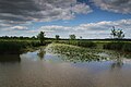
At the north and south, where the river Maine arrives in and leaves Angers, the landscape is formed by islands, ponds and floodplains which are a haven for birds and a typical flora of the
Metropolitan area
The commune of Angers is bordered by ten other
Climate
Angers has an oceanic climate, with moderate rain year-round. Winters have scarce frosts and snowfalls, and summers are warm and sunny.
| Climate data for Angers (located in Beaucouzé, 1991–2020 normals) | |||||||||||||
|---|---|---|---|---|---|---|---|---|---|---|---|---|---|
| Month | Jan | Feb | Mar | Apr | May | Jun | Jul | Aug | Sep | Oct | Nov | Dec | Year |
| Record high °C (°F) | 17.1 (62.8) |
21.2 (70.2) |
24.8 (76.6) |
29.7 (85.5) |
32.8 (91.0) |
40.1 (104.2) |
40.7 (105.3) |
38.7 (101.7) |
35.7 (96.3) |
30.5 (86.9) |
22.2 (72.0) |
19.0 (66.2) |
40.7 (105.3) |
| Mean daily maximum °C (°F) | 8.8 (47.8) |
9.9 (49.8) |
13.3 (55.9) |
16.4 (61.5) |
19.9 (67.8) |
23.5 (74.3) |
25.8 (78.4) |
25.9 (78.6) |
22.4 (72.3) |
17.4 (63.3) |
12.3 (54.1) |
9.2 (48.6) |
17.1 (62.8) |
| Daily mean °C (°F) | 6.0 (42.8) |
6.4 (43.5) |
9.0 (48.2) |
11.3 (52.3) |
14.7 (58.5) |
18.1 (64.6) |
20.0 (68.0) |
20.1 (68.2) |
16.9 (62.4) |
13.4 (56.1) |
9.1 (48.4) |
6.3 (43.3) |
12.6 (54.7) |
| Mean daily minimum °C (°F) | 3.3 (37.9) |
2.9 (37.2) |
4.6 (40.3) |
6.3 (43.3) |
9.6 (49.3) |
12.6 (54.7) |
14.3 (57.7) |
14.3 (57.7) |
11.4 (52.5) |
9.3 (48.7) |
5.9 (42.6) |
3.5 (38.3) |
8.2 (46.8) |
| Record low °C (°F) | −15.4 (4.3) |
−12.8 (9.0) |
−10.6 (12.9) |
−3.4 (25.9) |
−1.6 (29.1) |
2.3 (36.1) |
4.5 (40.1) |
5.1 (41.2) |
2.5 (36.5) |
−3.2 (26.2) |
−8.0 (17.6) |
−13.4 (7.9) |
−15.4 (4.3) |
| Average precipitation mm (inches) | 69.9 (2.75) |
54.4 (2.14) |
52.8 (2.08) |
54.7 (2.15) |
59.4 (2.34) |
48.7 (1.92) |
45.0 (1.77) |
48.2 (1.90) |
56.5 (2.22) |
71.9 (2.83) |
72.9 (2.87) |
74.9 (2.95) |
709.3 (27.93) |
| Average precipitation days | 11.4 | 9.5 | 9.4 | 9.7 | 9.2 | 6.8 | 6.1 | 7.1 | 7.6 | 10.6 | 11.9 | 11.7 | 110.9 |
| Average snowy days | 1.7 | 1.9 | 1.4 | 0.2 | 0.1 | 0.0 | 0.0 | 0.0 | 0.0 | 0.0 | 0.4 | 1.3 | 7.0 |
| Average relative humidity (%)
|
88 | 84 | 80 | 77 | 77 | 75 | 74 | 76 | 80 | 86 | 89 | 89 | 81.3 |
| Mean monthly sunshine hours | 68.4 | 97.7 | 142.3 | 179.6 | 205.0 | 224.2 | 235.3 | 225.3 | 191.7 | 120.9 | 84.1 | 70.8 | 1,845.1 |
| Source 1: | |||||||||||||
| Source 2: Infoclimat.fr (humidity, snowy days 1961–1990)[25] | |||||||||||||
Urban morphology

The oldest streets and buildings in Angers are located on the promontory where the Angers castle stands. The urban structure there dates back from the 13th, 14th and 15th centuries.[26]
A military presence there was attested from the 3rd century[27] and some remains of an antique city wall are still visible on the castle grounds.[28] This wall was built to protect the city from the Germanic invasions of AD 275 and 276.
During the Middle Ages, the castle was the core of the city's defence system, composed of tall city walls and river chains which prevented enemy ships from going up the Maine. The walls were last reconstructed between 1230 and 1240, by order of King Louis IX.[29] Today, portions of the wall are still visible in Rue Toussaint and on Boulevard Carnot, as are some towers, like the Tour Villebon and the Tour des Anglais.[citation needed]
Before the first cadastre (1810), the city had not extended much beyond its medieval limits: on and around the castle promontory, with some dwellings on the other bank of the Maine in a neighbourhood called La Doutre. That part of the city developed quickly during the industrial revolution and became a big river port. Industry was encouraged by firms like Bessonneau (textile factories) and Cointreau (distillery).[citation needed]
After 1850, many suburbs appeared around the train stations and the slate quarries to the south in Trélazé. Despite the port in La Doutre, demographic growth and urban extension were more significant on the eastern bank of the Maine, where the former Juliomagus had been founded.[citation needed]
The medieval city center was redeveloped and expanded from 1791. The Place du Ralliement, the main square, was then built in place of three churches destroyed during the French Revolution and, later, ring boulevards planted with trees replaced the city walls.[citation needed]
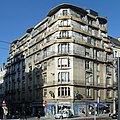
The architectural style used is mainly Haussmanian, but there are also some Palladian, Art Nouveau or Art Deco buildings.[citation needed]
After 1945 and the
As the metropolitan area continued to grow, commuting became more common. New shopping areas were constructed close to the villages which had been subsumed into the city. Because of the floodplains that surround the city north and south, Angers can only grow significantly on an east–west axis.[citation needed]
-
 The Tour des Anglais, a remaining part of the medieval city walls
 -
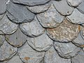 Traditional slated roof
 -
 Half-timbered houses in rue de l'Oisellerie
 -
 View of La Doutre; the industrial port has become a marina
 -
 The Place du Ralliement
 -
 A department store on a 19th-century street
 -
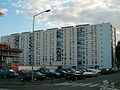 A council estate in La Roseraie
.jpg)


.jpg)

Green areas

Being both at the edge of the
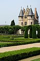
The oldest green areas date back from the Renaissance, when the moats of the castle were transformed into pleasure and kitchen gardens. Similar gardens were built by the aristocracy around their hôtels particuliers and physic garden were planted in hospices cloisters. The Jardin des plantes, the first botanical garden, dates back from the beginning of the 18th century. During the 19th century, others were built, for example the Faculty of Pharmacy garden and the Roseraie. The first recreational parks, for their part, were built during the Second French Empire. The étang Saint-Nicolas, made by a sluice on a small river, the Brionneau, was protected as early as 1936.
The Jardin du Mail (Mall Garden), an esplanade situated outside the ring boulevards, was built between 1820 and 1880 on the former Champs de Mars (Fields of Mars, a place where the garrisons used to train and parade). Another esplanade, the Mail François Mitterrand, was built in 1999 together with a garden inside the new Saint-Serge business district. During the 1960s the old gravel pits around the Maine were filled with water to form the Lac de Maine, which now hosts a marina. In 2010, a large amusement park, Terra Botanica, was inaugurated close to Saint-Aubin island.
-
 The Saint-Aubin island protected area
 -
 Planted quays around the river Maine
 -
 Jardin du Mail
 -
 Sunset on the Lac de Maine
 -


History
Prehistory and antiquity

The first sign of human presence in Angers dates back to around 400,000 BC.[31] Vestiges from the Neolithic are more abundant and include numerous polished stone axes. Burials from 4500 x 3500 BC were also discovered on the castle grounds.
During the 5th century BC, the Andecavi, a Celtic people, settled north of the Loire. By the end of the Iron Age, Angers was a relatively densely populated hillfort. While the settlement's Roman name—Juliomagus—may be older, it is only attested from the 3rd century. The Roman town consisted of many villas and baths and had an amphitheater as well as a Mithraeum, a temple dedicated to Mithra.
Successive Germanic invasions in AD 275 and 276 forced the inhabitants to move to the highest point of their city and to build a wall around a small area of around 9 hectares (22 acres).
Middle Ages
Angers received its first
From the 850s, Angers suffered from its situation on the border with Brittany and Normandy. In September 851, Charles the Bald and Erispoe, a Breton chief, met in the town to sign the Treaty of Angers, which secured Breton independence and fixed the borders of Brittany. However, the situation remained dangerous for Angers, and Charles the Bald created in 853 a wide buffer zone around Brittany comprising parts of Anjou, Touraine, Maine and Sées, which was ruled by Robert the Strong, a great-grandfather of Hugh Capet.
In 870, the

During the 12th century, after internal divisions in Brittany, the county of Nantes was annexed by Anjou. Henry II Plantagenêt kept it for more than 30 years. The grandson of Henry I of England, he also succeeded to the English crown and ruled the vast Angevin Empire, which stretched from the Pyrenees to Ireland.[34] The castle of Angers was then the seat of the Court and the dynasty. The Empire disappeared in 1204–1205 when the King of France, Philip II, seized Normandy and Anjou. Henceforth, there were no more counts of Anjou, as the French king had made Anjou a dukedom.
Now a part of the
Renaissance

King
In 1474,
.jpg)
In 1551, Angers became the seat of a bailiwick and the presidial court of a jurisdiction, a position the city kept until 1790. At the same time, with the growth of Protestantism in France, a Catholic was placed at the head of the city and its castle while the bourgeoisie formed a Catholic militia to protect Angers from the Huguenots. The bishop, Gabriel Bouvery, organized on his side an "Angevin League".
When the news of the
In 1598, the
Classical period

In 1619,
At the premature death of Louis XIII in 1643, his son
In 1652,
French Revolution

The first months of the
The
The city was defended by 4,000 Republican soldiers, whereas the Royalists were at least 20,000, but weakened by successive fights and deceases. The Siege of Angers occurred on 3 and 4 December 1793. The Royalists' bad tactics, as well as the strength of Angers city wall and castle, caused their loss. They consequently went back north for a while, around Le Mans, before crossing the Loire at Ancenis on 16 December.
In 1794, fierce repression was conducted in the whole region against the Royalists. In Angers, 290 prisoners were shot and 1020 died of illness in jail.[37] The city also welcomed many refugees, mostly Republicans living in Royalist rural areas. Between 19 and 31 May 1793, between 650 and 1000 Republican families sought asylum in Angers.[38]
Since 1800
.jpg)
During the 19th century, the city was deeply influenced by the urban transformations in Paris. The city traditionally had a somewhat sombre appearance from the quantity of local slate used in construction but many quarters were gradually destroyed, redeveloped, or rebuilt on the Parisian model.[16] The city wall, which formed a square around the old city core, was demolished around 1850 and replaced by wide boulevards. New districts of the city were also opened up on the opposite bank of the river.[16]
In 1849, the Angers-Saumur railway was built; it was extended to Nantes two years later. When completed, the line connected Paris to the Atlantic coast.
In 1850, a catastrophic failure of the Angers Bridge suspension bridge caused the deaths of over 200 soldiers. The disaster inhibited the construction of suspension bridges in France for two decades. The accident was mainly caused by soldiers' lilting march which created resonance in the bridge structure.[39]
In 1875, a "free faculty" was created. It was soon assimilated to the medieval Angevin University (Universitas Andegavensis), which had been dissolved during the French Revolution. The new faculty was canonically erected as the Catholic University of Angers (Université catholique d'Angers) by Pope Pius IX in 1879. However, in 1890, a law prohibited private institutions of higher education from calling themselves "universities". The institution was then renamed the "Free Faculty of Angers" (Faculté libre d'Angers), although it kept its original name on an informal basis. At the beginning of the 20th century, two higher education establishments, specializing in agriculture and commercial sciences, were opened.

During the first half of the 20th century, several Art Nouveau and Art Deco buildings were constructed, such as the Nouvelles Galeries, the Hotel des Postes, Hotel Continental, the Alcazar and the Maison bleue.
In September 1939, when
On the night of 28 May 1944, the first Allied bombing occurred over the Saint-Laud quarter. 243 people died and many others were wounded. Successive attacks on 29 and 30 May destroyed the train station and its surroundings[41] which were reconstructed in the 1950s.
After liberating
After the end of the war, the city experienced quick development and demographic growth. In 1971, a decision was made to reestablish a public university, and the Université catholique d'Angers was split between the Université catholique de l'Ouest (private) and the Université d'Angers (public). Angers continues to have two different universities.
Until the 1980s, Angers experienced several massive urban development plans, such as the construction of the Lac de Maine, and several vast council estates and shopping malls, as well as the construction of a highway which crossed the city through its center, a project that forced the destruction of many old buildings and destroyed the original quays on the Maine. Later, other urban plans were drawn up, with a new emphasis on nature and heritage protection, as well as on social mixing. During the 1990s, the redevelopment of the Saint-Serge quarter, located just north of the historical center, produced a new business center, gardens and university buildings.

Administration
.jpg)
Angers received its communal charter from
Until the
Angers is divided into eight
Being the
Demographics
In 2017, Angers had 152,960 inhabitants, 1.2% more than ten years before.
The population of Angers is relatively young, with 46% of the population being younger than 30 and 22% of residents over 60 years old.[44] This is partially explained by the presence of two universities, 21.0% of the population between 15 and 64 being pupils and students in 2017.[47]
|
|
| |||||||||||||||||||||||||||||||||||||||||||||||||||||||||||||||||||||||||||||||||||||||||||||||||||||||||||||||||||||
| |||||||||||||||||||||||||||||||||||||||||||||||||||||||||||||||||||||||||||||||||||||||||||||||||||||||||||||||||||||||
| Source: Base Cassini from EHESS (1793-1999)[48] and INSEE (1968-2017)[44] | |||||||||||||||||||||||||||||||||||||||||||||||||||||||||||||||||||||||||||||||||||||||||||||||||||||||||||||||||||||||
Economy

The early prosperity of the town was largely due to the nearby
Present-day Angers provides 45.7% of the Maine-et-Loire job positions. It is the 22nd-largest national job provider and the 3rd-largest one in northwestern France after Nantes and Rennes. Its unemployment rate (13.5% in 2017) is above the national rate. 20.7% of the people working in Angers have graduate or post-graduate qualifications.[47]
Cointreau continues to produce its orange triple-sec liqueur in nearby
Angers is an important convention center, with a present convention trade of around €8,000,000. The new convention center slated for 2016 has been cancelled in 2013.[52] The renovation of the previous convention center and the addition of a 400 conference room at the back by the garden should be finished in 2018.[53] The Parc des Expositions, where fairs are currently held, welcomes 600,000 visitors and more than 300 events each year. With its 27,000 m2 (290,626 sq ft), it is the biggest structure of its type in northwestern France.[54]
Health and education

The Hôtel-Dieu, founded in the 12th century, is one of the oldest hospitals in France. First located in the Hospice Saint-Jean, it moved into new buildings in 1870; it became
A center of learning, Angers boasts two renowned universities and several specialized institutions, altogether enrolling more than 26,000 students.

Angers is also home to engineering graduate schools, such as the Arts et Métiers ParisTech, top school in mechanical and industrial engineering and the ESEO, an engineering school in electronics and computer science and ESAIP, an engineering school in risk management and environment. Its education and research institutes are the driving force behind the city's science and technology industries. Angers's other educational institutions include lycées, training colleges, and a school of fine art.
Another Angers's Business School is
In addition to French schools and universities, an American university, St. Edward's University, has a new expanding campus in Angers. St. Edward's University is a diverse, Catholic liberal arts institution from Austin, Texas. The university has a partnership with UCO, and offers a variety of courses of undergraduate level and professional training.
Transport

Angers Tramway | ||||||||||||||||||||||||||||||||||||||||||||||||||||||||||||||||||||||||||||||||||||||||||||||||||||||||||||||||||||||||||||||||||||||||||||||||||||||||||||||||||||||||||||||||||||||||||||||||||||
|---|---|---|---|---|---|---|---|---|---|---|---|---|---|---|---|---|---|---|---|---|---|---|---|---|---|---|---|---|---|---|---|---|---|---|---|---|---|---|---|---|---|---|---|---|---|---|---|---|---|---|---|---|---|---|---|---|---|---|---|---|---|---|---|---|---|---|---|---|---|---|---|---|---|---|---|---|---|---|---|---|---|---|---|---|---|---|---|---|---|---|---|---|---|---|---|---|---|---|---|---|---|---|---|---|---|---|---|---|---|---|---|---|---|---|---|---|---|---|---|---|---|---|---|---|---|---|---|---|---|---|---|---|---|---|---|---|---|---|---|---|---|---|---|---|---|---|---|---|---|---|---|---|---|---|---|---|---|---|---|---|---|---|---|---|---|---|---|---|---|---|---|---|---|---|---|---|---|---|---|---|---|---|---|---|---|---|---|---|---|---|---|---|---|---|---|---|
| ||||||||||||||||||||||||||||||||||||||||||||||||||||||||||||||||||||||||||||||||||||||||||||||||||||||||||||||||||||||||||||||||||||||||||||||||||||||||||||||||||||||||||||||||||||||||||||||||||||
Angers is situated on the crossroads of three highways, the A11, to Paris and Nantes, the A87 to La Roche-sur-Yon and the A85 to Tours and Lyon. National roads connect the city with Rennes, Caen and Laval.
Before the construction of bypasses during the 2000s, the A11 crossed the city center, following the river Maine, and passed just below the castle. Causing air pollution and noise and disfiguring the Maine quays, the portions of the former highway which are still in place should be redeveloped in the coming years.
Angers inaugurated the new Irigo[59] tram system on 25 June 2011. The tramway consists of one 12 km (7.46 mi) line with 25 stops. The line runs from Avrillé-Ardenne in the north to Angers-Roseraie in the south, passing by the center and the train station. Service is provided by Keolis using 17 Alstom Citadis trams.[60] The system uses partial ground-level power supply, which avoids aerial wires and preserves the historical character of the city center. A second line is scheduled for 2018–2022. Besides the tram, Irigo also organizes the bus network in Angers consisting of 13 urban lines and 12 suburban lines.
The bus station, situated outside the
Angers is on both the
.The nearest airport is
Culture
Main sights

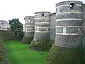
The Château d'Angers, built on a schist promontory, dominates the river Maine and the old town. Its site has been occupied since antiquity; the castle itself was built between 1230 and 1240 by Louis IX of France. The massive walls are about one kilometer long and punctuated by 17 towers; they were built with horizontal slices of tuff and schist, giving it strength and an original striped look. During the 15th century, a chapel and the Châtelet were added in the courtyard.
The
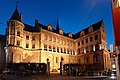
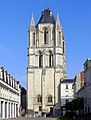
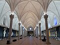
The Angers Cathedral is a major landmark in the cityscape, with its two spires culminating at 75 meters (246 ft). The construction of the current building started during the 12th century on the remains of an older sanctuary. The original structure, romanesque, received gothic columns and vaults in the middle of the 12th century, giving birth to the Angevin gothic, a style that quickly spread in Western France and the Angevin possessions in Italy. Sculptures and architectural details were added to the façade during the 16th century. The twin spires were built in 1518 and 1523. The neighbouring Palais du Tau, the former episcopal palace, dates from the 12th century.
The skyline is also marked by the Tour Saint-Aubin. Completed in 1170, it was the bell-tower of an abbey closed during the French Revolution and destroyed in 1810. Elaborately sculptured 11th and 12th century arcades also survive in the courtyard of the Prefecture.[61] Another abbey, the Abbaye Toussaint, founded during the 13th century, was also partially pulled down and only the church and parts of the cloister are still visible. On the southern limits of the commune, close to the Maine, stands the Couvent de la Baumette, founded during the 15th century by René of Anjou.
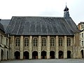
La Doutre, an old quarter located on the western bank of the Maine and facing the castle, contains two major medieval sites, the former Abbaye du Ronceray, built during the 11th and 12th century, and the Hôpital Saint-Jean, founded by Henry II of England and used as the city hospital until 1870.
-
 The distinctive striped towers of the castle
 -
 The Châtelet in the castle
 -
 House Poisson
 -
 Façade of House of Croissant
 -
 Logis Pincé
 -
 The "Blue House"
 -
 The cathedral
 -
 Inside the cathedral
 -
 Palace of Tau
 -
 Tower of Saint-Aubin
 -
 Abbey of Ronceray
 -
 Abbey of Saint Nicholas (Mother-House ofGood Shepherd Sisters)
 -
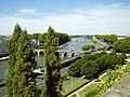
 The bridges over Maine (view from the Angers Castle)


.JPG)
Museums

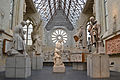
The Musée des Beaux-Arts d'Angers, located in the Renaissance Logis Barrault, displays a collection of paintings and sculptures dating from the 14th century to today. It is particularly renowned for its 18th-century paintings, including works by Jean-Baptiste Greuze, Van Loo, Antoine Watteau, Jean-Honoré Fragonard, and Jean Siméon Chardin. The museum also contains a graphic design studio, a gallery devoted to the history of Angers and a temporary exhibition gallery. The institution has an annexe at the château in Villevêque, a village located several kilometers north of the city.
Inside the castle, a special gallery displays the Apocalypse Tapestry, ordered by Louis I of Naples at the end of the 14th century. It is more than 140 meters (460 ft) long, the largest medieval tapestry in the world. Inspired by manuscript miniatures, the successive scenes, designed by Jean Bondol, illustrate the Apocalypse of St John.
Located inside the old Hôpital Saint-Jean, the Musée Jean-Lurçat et de la tapisserie contemporaine displays tapestries dating from the 19th and 20th centuries. The museum is dedicated to Jean Lurçat, an artist noted for his role in the revival of contemporary tapestry, and notably exhibits his "Chant du Monde", a modern echo to the Apocalypse Tapestry made after the bombing of Hiroshima.
The Muséum d'histoire naturelle d'Angers has been located in the 1521 Hôtel Demarie-Valentin since 1885. It exhibits a large collection of mounted animals and fossils, divided in three departments, one for zoology, one for botany and the last one for paleontology and geology.
The Logis Pincé, constructed during the Renaissance, is the home of the museum of the same name. It displays Egyptian, Greek, Roman, and Etruscan antiquities as well as Chinese and Japanese artifacts.
Located in the Abbaye Toussaint, the Galerie David d'Angers gathers sculptures, reliefs, and medallions by
Angers also enjoys a Maison de l'Architecture, which organizes various exhibitions and workshops, as well as several temporary exhibition galleries distributed in the city center. Outside the commune limits are also an aviation museum and a museum of communications.
-
 The Musée des Beaux-Arts
 -
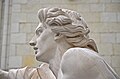
 Les Génies des Arts by François Boucher, at the Musée des Beaux-Arts
 -
 Italian drawing, 17th century, at the Musée des Beaux-Arts
 -
 Musée Jean-Lurçat
 -
 Galerie David d'Angers
 -
 Galerie David d'Angers


.JPG)
.jpg)

Entertainment and performing arts

The Grand Théâtre, dominating the Place du Ralliement, was first built in 1791, but destroyed by a fire in 1853. The existing building was completed in 1871 and its auditorium contains six stalls and four balconies, totalling 730 seats. The Théâtre du Quai, inaugurated in 2007, has two auditoriums: one contains 980 seats and several balconies, and the other, more flexible, can welcome 400 seated or 960 standing spectators. The Grand Théâtre and the Théâtre du Quai are the venues of three institutions, Angers-Nantes Opéra, an opera company also based in Nantes, the Contemporary Dance National Center (CNDC), inaugurated by Alwin Nikolais in 1978, and the Nouveau théâtre d'Angers (NTA).
The
The Chabada, a popular concert hall, is the cradle of the Angevin contemporary scene and several groups and performers were discovered there, Les Thugs, a punk band formed in 1983, being the first ones. The local scene also includes the alternative rock group La Ruda, the power pop band Pony Pony Run Run, the world music band Lo'Jo and Titi Robin, a performer influenced by Gypsy and Arabic music.
The Premiers Plans festival, dedicated to European first films and meant to help new directors meet their audience, is conducted every year and lasts one week. The films are screened in three small cinemas, while two big generalist multiplexes also exist in Angers.
Media
Angers had a local TV channel Angers 7 which went bankrupt in 2010 and was replaced 3 years later by Angers Télé. The national French channel
Sport

Angers has many sport teams playing at top levels.
Notable people
- Joan of England, Queen of Sicily (1165–1199), Queen of Sicily.[62]
- René of Anjou (1409–1480), Duke of Anjou and Count of Provence.[63]
- Guillaume Poyet (ca.1473–1548), a French magistrate.[64]
- Jean Bodin (1529–1596), philosopher and jurist.[65]
- François Guyet (1575–1655), philologist
- Gilles Ménage (1613–1692), a French scholar.[66]
- Joseph Proust (1754–1826), chemist responsible for Proust's law
- Michel Eugène Chevreul (1786–1889), chemist
- David d'Angers (1788–1856), sculptor.[67]
- Charles Négrier (1792-1862), physician, military doctor, medical researcher and academic
- François-Joseph Grille (1792–1853), librarian
- Germanicus Mirault (1796–1879), surgeon
- Prosper Ménière(1799–1862), physician
- Frédéric Alfred Pierre, comte de Falloux (1811–1886), a French politician and author.[68]
- Zacharie Astruc (1835–1907), artist
- René Bazin (1853–1932), writer and educator.[69]
- Fernand Charron (1866–1921), pioneer of motor racing and automobile manufacturing
- Jean Bosler (1878–1973), astronomer
- Yves de la Casinière (1897–1971), composer
- Jean-Adrien Mercier (1899–1995), illustrator, poster artist, and advertising designer
- Jean Durtal (1905–1999), poet and novelist
- Hervé Bazin (1911–1996), writer
- Henri Dutilleux (1916–2013), composer
- Joseph Wresinski (1917–1988), humanitarian activist
- André Bazin (1918–1958), critic of the French New Wave
- Fernande Grudet(1923–2015), brothel-keeper
- Jacques Bompaire (1924–2009), Hellenist
- Jacques Loussier (1934–2019), composer and jazz pianist
- Valerie Trierweiler(born 1965), political journalist and author
- Eriq Ebouaney (born 1967), actor
- Vincent Boussard (born 1969), opera and theatre director
- Caroline Giron-Panel (born 1979), historian and musicologist
- Nicolas Mahut (born 1982), tennis player
- Juliana Mialoundama (born 1993), basketball player
- Sofiane Boufal (born 1993), football player
- Adèle Castillon (born 2001), a musician
Twin towns – sister cities
See also
Notes
- ^ "Répertoire national des élus: les maires" (in French). data.gouv.fr, Plateforme ouverte des données publiques françaises. 13 September 2022.
- ^ "Populations légales 2021". The National Institute of Statistics and Economic Studies. 28 December 2023.
- ^ INSEE
- ^ "Angers". The American Heritage Dictionary of the English Language (5th ed.). HarperCollins. Retrieved 11 May 2019.
- ^ "Angers". Collins English Dictionary. HarperCollins. Retrieved 11 May 2019.
- ^ "Angers" (US) and "Angers". Lexico UK English Dictionary. Oxford University Press. Archived from the original on 26 July 2020.
- ^ "Angers (49000), Maine-et-Loire". www.linternaute.com.
- ^ Téléchargement du fichier d'ensemble des populations légales en 2017, INSEE
- ^ "Étude comparative des villes européennes" (PDF).
- ^ ISBN 2-85023-076-6.
- ^ Ptolemy, Geography, II, 8, 8.
- ISBN 2-13-038660-1.)
{{cite book}}: CS1 maint: location missing publisher (link - ^ Charles Rostaing, Op. cit., p. 47
- ^ Charles Rostaing, Op. cit., p. 46–47.
- ISBN 9782600028837– via Google Books.
- ^ a b c d e f EB (1878).
- ^ "City official website". Archived from the original on 25 November 2008.
- ISBN 2-85575-070-9.)
{{cite book}}: CS1 maint: location missing publisher (link - ^ "Laissez-vous conter Angers". vpah.culture. Archived from the original on 16 May 2011. Retrieved 1 August 2012.
- ^ "Distinctions : Angers.fr". Archived from the original on 13 February 2013. Retrieved 23 August 2017.
- ^ "City website". Archived from the original on 1 August 2013.
- ^ Elevations Archived 2 May 2011 at the Wayback Machine, Institut geographique national
- ^ "Données climatiques de la station de Beaucouzé" (in French). Meteo France. Retrieved 9 January 2016.
- ^ "Climat Pays de la Loire" (in French). Meteo France. Archived from the original on 28 May 2019. Retrieved 9 January 2016.
- ^ "Normes et records 1961–1990: Angers-Beaucouzé (49) - altitude 50m" (in French). Infoclimat. Retrieved 9 January 2016.
- ^ "Fasti Ecclesiae Gallicanae - Extrait du volume d'Angers". fasti.univ-paris1.fr.
- ^ Archives 49 : il était une fois l'Anjou Archived 12 July 2014 at the Wayback Machine.
- ^ Angers, le château, Inventaire général des monuments et richesses artistiques de la France, 1991
- ^ Historique du château d'Angers, Inventaire général du patrimoine culturel
- ^ "Rives Nouvelles". angers.fr. Archived from the original on 22 June 2012.
- ISBN 978-1456043087.
- ^ "City website".[permanent dead link]
- ^ Michel Dillange. Op. cit, p 59–60
- ^ Le duché de Bretagne et la politique Plantagenêt aux XII et XIII siecles, Judith Everard. ", in Marin Aurell and Noël-Yves Tonnerre éditeurs. Plantagenêts et Capétiens, confrontations et héritages, Poitiers. Brepols, 2006, Turnhout. Collection Histoires de famille. La parenté au Moyen Âge, p. 202
- ^ Histoire de René d'Anjou, Louis François Villeneuve-Bargemont tome II (1446–1476) Editions J. J. Blaise, Paris : 1825
- ^ Pierre Miquel, Op. cit., p. 286
- ^ Jacques Hussenet (dir.), " Détruisez la Vendée ! ", p. 452–453.
- ^ Guy-Marie Lenne, Les Réfugiés de la guerre de Vendée, p. 20–25
- ^ Base de connaissance Art et Histoire
- ^ "Lesplantagenets.fr". Archived from the original on 7 July 2012. Retrieved 2 August 2012.
- ^ a b Conseil general de Maine-et-Loire (ed.). "L'Anjou dans la seconde guerre mondiale".
- ^ City website (ed.). "Août 1944. Angers est libérée". Archived from the original on 13 February 2013. Retrieved 2 August 2012.
- ^ Mairie d'Angers, Trobinoscope, accessed 16 May 2023
- ^ a b c "Évolution et structure de la population en 2017". Insee. Retrieved 13 August 2020.
- ^ "Angers Loire Métropole data". Archived from the original on 17 July 2011.
- ^ CU Angers Loire Métropole (N° SIREN : 244900015), BANATIC. Accessed 4 April 2022.
- ^ a b Dossier complet, Commune d'Angers (49007), INSEE
- ^ Des villages de Cassini aux communes d'aujourd'hui: Commune data sheet Angers, EHESS (in French).
- ^ EB (1911).
- ^ "Website of the école Supérieure d'Agriculture d'Angers". Archived from the original on 2 September 2011. Retrieved 2 August 2012.
- ^ "Vidéos : Angers.fr". Archived from the original on 23 September 2015. Retrieved 1 December 2018.
- ^ Angers. Abandon du nouveau Centre des congrès : "Un reniement de plus !"
- ^ "Le projet de rénovation du centre de congrès est lancé : Angers.fr". Archived from the original on 23 September 2015. Retrieved 9 August 2015.
- ^ "Map of the Parc des Expositions" (PDF).[permanent dead link]
- ^ "CHU info". chu-angers.fr.
- ^ Les chiffres clés 2008 on the hospital website
- ^ "Teaching, research and industry". Angers.fr. 18 November 2009. Retrieved 15 September 2011.
- ^ "Meilleure université de France : l'université d'Angers sur la première marche du podium". www.linternaute.com. 22 July 2015.
- ^ "Irigo.fr : site officiel des transports en commun de l'agglomération d'Angers". bustram.irigo.fr (in French). Retrieved 9 May 2017.
- ^ "Angers tram opens". Railway Gazette. 29 June 2011. Archived from the original on 13 October 2011. Retrieved 1 July 2011.
- ^ "Eglise Saint Aubin". Archived from the original on 11 January 2005. Retrieved 2 July 2006.
- ^ Norgate, Kate (1892). . Dictionary of National Biography. Vol. 29. pp. 386–388.
- ^ . Encyclopædia Britannica. Vol. II (9th ed.). 1878. p. 58-59.
- ^ . Encyclopædia Britannica. Vol. 22 (11th ed.). 1911. p. 238.
- ^ Goyau, Pierre-Louis-Théophile-Georges (1907). . Catholic Encyclopedia. Vol. 2.
- The American Cyclopædia. Vol. XI. 1879.
- ^ . Encyclopædia Britannica. Vol. 7 (11th ed.). 1911. p. 862.
- ^ . Encyclopædia Britannica. Vol. 10 (11th ed.). 1911. p. 155.
- ^ . Encyclopædia Britannica. Vol. 3 (11th ed.). 1911. p. 561.
- ^ "Les villes jumelles". angers.fr (in French). Angers. Retrieved 21 April 2021.
References
- Baynes, T. S., ed. (1878), , Encyclopædia Britannica, vol. 2 (9th ed.), New York: Charles Scribner's Sons, p. 29
- Chisholm, Hugh, ed. (1911), , Encyclopædia Britannica, vol. 2 (11th ed.), Cambridge University Press, pp. 8–9
Further reading
- ISBN 978-2-85672-008-0.
- Tancrède Abraham (1876). Angers et ses environs. Album de gravures à l'eau-forte (in French). Château-Gontier: J.-B. Bezier.
- Daniel Schweitz (2006). Châteaux et forteresses du Moyen Âge en Val de Loire, Touraine, Anjou, Berry, Orléanais, Vendômois, Marche bretonne (in French). Tours: CLD. ISBN 978-2-85443-490-3.
- Jean-François Bodin (1823). Recherches historiques sur l'Anjou et ses monumens: Angers et le Bas-Anjou, Volume 2 (in French). Degouy. ISBN 978-2-85443-490-3.
External links
- Official website
- Angers Tourist Office Archived 24 January 2013 at the Wayback Machine
- "A Visit to the Slate Quarries of Angers", France, article from the Scientific American – Supplement No. 974, Munn & Co., New York, 1894, on Stone Quarries and Beyond.
| |
|
| International | |
|---|---|
| National | |
| Geographic | |
| Other | |