
Antalya Province
Antalya Province
Antalya ili | |
|---|---|
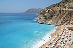
 Konyaaltı Beach in Antalya | |
 Location of the province within Turkey | |
| Country | Turkey |
| Seat | Antalya |
| Government | |
| • Mayor | Muhittin Böcek (CHP) |
| • Vali | Hulusi Şahin |
| Area | 20,177 km2 (7,790 sq mi) |
| Highest elevation | 3,086 m (10,125 ft) |
| Lowest elevation | 0 m (0 ft) |
| Population (2022)[1] | 2,688,004 |
| • Density | 130/km2 (350/sq mi) |
| Time zone | UTC+3 (TRT) |
| Postal code | 07010 to 07995 |
| Area code | (+90) 242 |
| Vehicle registration | 07 |
| Website | www www |
.JPG)
Antalya Province (Turkish: Antalya ili) is a province and metropolitan municipality of Turkey. It is located on the Mediterranean coast of south-west Turkey, between the Taurus Mountains and the Mediterranean Sea. Its area is 20,177 km2,[2] and its population is 2,688,004 (2022).[1]
Antalya Province is the centre of Turkey's tourism industry, attracting 30% of foreign tourists visiting Turkey. Its capital city of the same name was the world's third most visited city by number of international arrivals in 2011, displacing New York. Antalya is Turkey's biggest international sea resort. The province of Antalya corresponds to the lands of ancient Lycia to the west, Pamphylia to the east, and part of Pisidia to the north. It features a shoreline of 657 km (408 mi) with beaches, ports, and ancient cities scattered throughout, including the World Heritage Site Xanthos. The provincial capital is Antalya city with a population of 1,344,000.
Antalya is the fastest-growing province in Turkey; with a 4.17% yearly population growth rate between years 1990–2000, compared with the national rate of 1.83%. This growth is due to a fast rate of urbanization, particularly driven by tourism and other service sectors on the coast.
Etymology
The city and thus the province are named after
History

Antiquity
Antalya has been settled since pre-historic times. Evidence of human habitation dating back to the early Paleolithic age (150,000-200,000) years has been discovered in the
According to
According to Greek legend, there was immigration by a Greek tribe called the Akhaioi (from the northern Peloponnese) to the area, after the Trojan War, and eventually many Greek settlements built up along the coast and inland. In the Hellenistic period, the western parts of the later Antalya were regarded as Lycia, whereas the east was Pamphylia, and the extremes east Cilicia, while Pisidia was to the north. These communities grew into independent cities, and eventually a federation was set up, under the name of Pamphylia.

Before the Ancient Roman conquest Lycia was a polity with the first democratic constitution in the world, which later partly inspired the U.S. Constitution.[4]
Antalya was part of the Lydian kingdom from the 7th century BC until Lydia was defeated by the Achaemenid Empire during the Battle of Sardis in 546 BC. The Macedonian commander Alexander the Great ended Persian rule and in around 334 BC conquered the cities of the area one by one—except for Termessos and Sillyon which managed to repulse his armies in 333 BC. After the death of Alexander in 323 BC, a long battle erupted between his generals that lasted until 188 BC.
The reign of the kingdom of Pergamon began with the defeat of the Seleucid army at Apamea. Shortly after this the city of Antalya was founded. When Attalos III, the last king of Pergamom, died in 133 BC he left his kingdom to the Roman Republic. At this time the area is dominated by pirates based in small cities along the coast.
The Byzantines
During the mid-Byzantine era (the 5th and 6th centuries) the city of Antalya grew beyond the city walls.
From the

The Seljuk Turks
The area was conquered by the
The Ottoman Empire onwards

The area passed through many hands before its final occupation by the
There are many archaeological sites in the province including three National Parks and three Specially Protected Areas.
Geography

Antalya province is situated in south-west
The Antalya basin consists of three sub-basins: the
: 135The western part of the Antalya plain is crossed by two rivers: the Karaman Çay, west of the city, and the Düden Çay, east of the city.[8]: 142 A wide undersea canyon extends to the south of the area where these rivers flow into the Antalya Gulf.[8]: 142 Offshore from the Aksu's mouth, there is no canyon; there is instead a shallow marine shelf where the river deposits sediments in a broad area.[8]: 142
West of the Aksu basin is a 30x40 km-wide area of tufa and travertine deposits that mark the SW boundary of the basin; the city of Antalya is built on top of this area.[9]: 9–10 These deposits were formed from prehistoric cold springs in the early Pleistocene.[9]: 17 They are deepest at the west end, where they are 250 m deep; they get shallower towards the east and are 30 m deep at the easternmost part.[9]: 9
A narrow band of limestone deposits stretch from
- Geography of Antalya Province
-
 1200 BC
 -
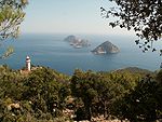
 Korsan Koyu Peninsula, an example of typical geography of western Antalya
 -
 Olymposbeach
 -
 Oymapinar Dam on the Manavgat River
 -
-


.JPG)
.jpg)
Districts

Antalya province is divided into 19 districts:[10]
Demographics
| Year | Pop. | ±% p.a. |
|---|---|---|
| 1927 | 204,372 | — |
| 1935 | 242,609 | +2.17% |
| 1940 | 256,366 | +1.11% |
| 1950 | 311,442 | +1.97% |
| 1960 | 416,130 | +2.94% |
| 1970 | 577,334 | +3.33% |
| 1980 | 748,706 | +2.63% |
| 1990 | 1,132,211 | +4.22% |
| 2000 | 1,719,751 | +4.27% |
| 2011 | 2,035,563 | +1.54% |
| 2020 | 2,548,308 | +2.53% |
| Source:Turkstat[11][12] | ||
The population of Antalya province is estimated 2,426,356 in 2018. Antalya is the fifth province of Turkey with high foreigner resident population which is 6,343.[13]
Education
The province of Antalya has two public (Akdeniz University, Alanya Alaaddin Keykubat University), and three private universities (Alanya University, Antalya Belek University, Antalya Science University). Antalya's compulsory education system is run by the Turkish Ministry of National Education
Media and broadcasting
Antalya has a number of local media such as radio channels (such as
Places of interest


The highest point of the
Ancient cities and ruins

There are sites of historical and archaeological interest all over Antalya including
- The Ariassos 22 km (14 mi). along the Antalya-Burdurhighway.
- In the district of Olympos and Rhodiapolis
- In the district of Phellos, Sure
- In the district of
- In the district of Finike: Arycanda, Limyra, Melanippe, Trebema, and Lycian rock graves
- In the district of Kemer, (southwest of Antalya): Idyros, and the Lycian city of Phaselis, and the castle of Gedelme.
- In Side; the town itself, Seleucia (Pamphylia), a temple of Athena and another of Apollo
- The church of Saint Nicholas in Demre
- The caves of Beldibi, Damlataş and Karain
- , high in the mountains 35 km (22 mi) northwest of Antalya.
- Karaburun and Seyamük in Elmalı
- Kyneai in Kaş
- Poğla in Korkuteli
- Silliyon (the town of Serik), dates back to the 4th century BC
- Simena in Kekova
- Tlos
- The ancient Lycian city of Xanthos (Kınık)
- The ancient city of Lyrborton nearKepez.
- The Carvanserai's of Kirkgöz and Evdirhan in Doşemealti.
National parks


- Koprulu National Park
- Termessos National Park
- Olympos National Park
Sites of natural beauty
- Manavgat Waterfall
- Kursunlu Waterfall
- Duden Waterfall
- Oymapinar Dam
- Köprülü Canyon
- Saklıkent Canyon
- Düzler pine forest
- Saklikent Ski Resort
- Chimaera
Caves

There are more than twenty caves in Antalya Province, among them some are show caves and registered natural monuments.[14]
- İbradi
- Aslanlı Cave
- Beldibi Cave
- Büyükdipsiz Cave
- Çimeniçi Cave, Alanya
- Damlataş Cave
- Derya Cave
- Dim Cave
- Geyiklibayırı Cave, Geyiklibayırı village
- Akseki, Antalya
- Karain Cave, Yağca, Döşemealtı
- Kocadüden Cave, Akseki
- Kocain Cave,
- Konakaltı Cave
- Küçükdipsiz Cave
- Mahrumçalı Cave, Manavgat
- Oruç Düdeni Cave
- Papazkayası Cave
- Peynirdeliği Cave, Kemer
- Tilkiler Cave
- Yerköprü Cave (Antalya), Ürünlü village, Akseki
Notable people
- Mevlüt Çavuşoğlu, Turkish diplomat and politician; former Minister of Foreign Affairs of Turkey
See also
References
- ^ TÜİK. Retrieved 19 September 2023.
- ^ "İl ve İlçe Yüz ölçümleri". General Directorate of Mapping. Retrieved 19 September 2023.
- ^ See "Antalya / Turkey". Archived from the original on 2007-01-04. Retrieved 2007-02-26. and [1] Archived 2007-02-06 at the Wayback Machine
- ^ U.S. Politics Online Archives: American Literature
- S2CID 130751791.
- OCLC 86068902.
- ^ "Present and future Köppen-Geiger climate classification maps at 1-km resolution". Nature Scientific Data. DOI:10.1038/sdata.2018.214.
- ^ . Retrieved 10 February 2023.
- ^ a b c d Kaya, Ersin (2014). Structure and Tectonics of the Late Cenozoic Transtensional Aksu Sedimentary Basin, SW Anatolia. Retrieved 12 February 2023.
- ^ Büyükşehir İlçe Belediyesi, Turkey Civil Administration Departments Inventory. Retrieved 8 June 2023.
- ^ "Census Results". Turkstat. Archived from the original on 2016-08-02. Retrieved 22 January 2021.
- ^ "Onlinelibrary of Turkstat". Turkstat. Archived from the original on 2014-06-02. Retrieved 22 January 2021.
- ^ Turkish Statistical Institute (2008). "2007 Census, population living in cities". Turkish Statistical Institute. Archived from the original on 4 March 2008. Retrieved 2008-01-21.
- ^ "Antalya Mağaraları" (in Turkish). Kültür ve Turizm Bakanlığı - Yatırım ve İşletmeler Genel Müdürlüğü. Retrieved 2017-01-25.
External links
 Media related to Antalya Province at Wikimedia Commons