
Appenzell Alps
| Appenzell Alps | |
|---|---|
 Churfirsten group, with the Schibestoll, Zuestoll, Brisi, Frümsel, and Selun (left to right) | |
| Highest point | |
| Peak | Säntis |
| Elevation | 2,502 m (8,209 ft) |
| Coordinates | 46°38′28″N 8°25′6″E / 46.64111°N 8.41833°E |
| Naming | |
| Native name | Appenzeller Alpen (German) |
| Geography | |

| |
| Country | Zurich |
| Parent range | Western Alps |
| Borders on | Glarus Alps, Rätikon and Schwyz Alps |
| Topo map | Swiss Federal Office of Topography swisstopo |
The Appenzell Alps (
St. Gallen and are bordered by the Glarus Alps to the west and the Rätikon
to the south-east.
Sub-ranges
The range is split up into six sub-ranges:
- Alpstein, central group, highest summit: Altmann, 2,435 m
- Alpstein, northern group, highest summit: Säntis, 2,502 m
- Alpstein, southern group, highest summit: Roslen- or Saxerfirst, 2,151 m
- Alviergruppe, highest summit: Gamsberg, 2,385 m
- Churfirsten, highest summit: Hinterrugg, 2,306 m
- Speer - Mattstock, highest summit: Speer, 1,950 m
Geography
Principal summits
The principal summits of the Appenzell Alps are:
- Säntis, 2,502 m
- Girenspitz, 2,448 m
- Altmann, 2,436 m
- Gamsberg, 2,385 m
- Fulfirst, 2,384 m
- Wildhuser Schafberg, 2,373 m
- Wisswand, 2,346 m
- Alvier, 2,343 m
- Gauschla, 2,310 m
- Hinterrugg, 2,306 m
- Brisi, 2,279 m
- Frümsel, 2,267 m
- Zuestoll, 2,235 m
- Margelchopf, 2,163 m
- Silberplatten, 2,158 m
- Hundstein, 2,157 m
- Schibestoll, 2,136 m
- Leistchamm, 2,101 m
- Gamser Rugg, 2,076 m
- Kreuzberge, 2,065 m
- Marwees, 2,056 m
- Lütispitz, 1,987 m
- Speer, 1,950 m
- Mattstock, 1,936 m
- Schäfler, 1,924 m
- Federispitz, 1,865 m
- Gonzen, 1,830 m
- Hoher Kasten, 1,795 m
- Gulmen, 1,789 m
- Stockberg, 1,781 m
- Kronberg, 1,663 m
- Ebenalp, 1,640 m
- Hochalp, 1,521 m
Other interesting summits
Gallery
-
 Säntis from Schwägalp
 -

-
 Summit of Churfirsten
 -
 Falensee
 -
 Restaurant Aescher-Wildkirchli near Ebenalp
 -
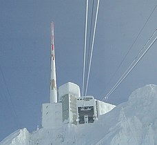 Summit of Säntis


