
Aragvi
(Redirected from
Aragvi River
)| Aragvi | |
|---|---|
 View upstream Aragvi River and along Tbilisi–Senaki–Leselidze highway (taken from around Jvari Monastery) | |
| Native name | არაგვი (Georgian) |
| Location | |
| Country | Georgia |
| Region | Caucasus |
| Physical characteristics | |
| Source | Caucasus |
| • location | Gudauri, Mtiuleti, Georgia |
| • coordinates | 42°20′41″N 44°41′42″E / 42.34459°N 44.69502°E |
| • elevation | 1,045 m (3,428 ft)[1] |
| Mouth | flows into the Mtkvari (Kura) |
• location | Mtskheta, Georgia |
• coordinates | 41°50′24″N 44°43′34″E / 41.84003°N 44.72611°E |
• elevation | 445 m (1,460 ft)[2] |
| Length | 112 km (70 mi) |
| Basin size | 2,740 km2 (1,060 sq mi) |
| Basin features | |
| Progression | Kura→ Caspian Sea |
The Aragvi (
hydro-electric power station generate much of Georgia's power, and its construction in 1986 formed the Zhinvali Reservoir, upon whose north-western shores rises Ananuri
castle with its 17th-century Church of the Assumption.
Confusion over name and course
Given its etymology (see below; the word simply means "river"), the exact course of the Aragvi River is the source of some confusion. The river has several important tributaries, all called "aragvi":
The Tetri Aragvi ("White Aragvi").
Etymology
See არაგვი for the origin of the name.
Use and infrastructure
The 102-metre (335 ft) high dam by Zhinvali is one of the largest in Georgia. Besides generating up to 130 MW of electricity, the waters of the Aragvi travel down a 36.7-kilometre (22.8 mi) pipe to provide drinking water in Tbilisi and to irrigate fields.
Gallery
-
 Zhinvali reservoir
 -
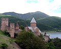 Ananuri castle
 -
 Hydro-electric dam on the Aragvi
 -
 The Source of The Aragvi River to the North of Gudauri


Notes
- ^ Soviet General Staff Maps, 1:50,000 series, sheet K-38-54-W
- ^ Soviet General Staff Maps, 1:50,000 series, sheet M-38-78-A
- ^ Statistical Yearbook of Georgia: 2020, National Statistics Office of Georgia, Tbilisi, 2020, p. 12.
- ^ Georgian: თეთრი არაგვი, tetri aragvi. Source: approx. 42°31'27.13"N, 44°24'2.40"E
- ^ Georgian: შავი არაგვი, shavi aragvi. Source: approx. 42°27'25.18"N, 44°42'40.80"E
- ^ Georgian: ფშავის არაგვი, pshavis aragvi. Source: approx. 42°23'57.01"N, 45°8'42.74"E
- ^ Georgian: ხევსურეთის არაგვი, khevsuretis aragvi. Source: approx. 42°33'45.75"N, 44°57'12.78"E
Wikimedia Commons has media related to Aragvi River.
| International | |
|---|---|
| National | |