
Arakan
Arakan | |
|---|---|
Third Burmese Empire (18th century) Division of British Burma (19th century) Province of Myanmar (1948–present) | |
| Capital | Dhanyawadi Waithali Pyinsa Parein Nareinzara Toungoo |
| Religion | Buddhism, Islam, Hinduism |
Arakan (/ˈærəkæn/ or /ˈɑːrəkɑːn/[1]) is the historical geographical name of Rakhine State, Myanmar (formerly Burma). The region was called Arakan for centuries until the Burmese military junta changed its name in 1989. The people of the region were known as Arakanese.[2][3][4]
Arakan's first states can be traced to the 4th century. Arakan was one of the first
Etymology
According to
Geography

Arakan is a coastal geographic region in
The region's principal rivers are the Nāf estuary and the
The main towns are coastal and include
History
Antiquity


.jpg)
Arakan has been recognized “as one among other Burmese kingdoms competing for the control of power in Lower Burma”.[11] The cities of Bago, Bagan and Inwa were the centres of political power in Burma proper. In contrast, independent Arakanese states were based in the capital cities of Dhanyawadi, Vesali, Laungyet and Mrauk-U. The ruins of these cities are located in northern Arakan in proximity to the borderland of Bengal.
It is unclear who the earliest inhabitants were; some historians believe the earliest settlers included the Burmese
Arakan came under strong Indic influence from the
According to Pamela Gutman, "Arakan was ruled by kings who adopted Indian titles and traditions to suit their own environment. Indian Brahmins conducted royal ceremonies, Buddhist monks spread their teachings, traders came and went and artists and architects used Indian models for inspiration. In the later period, there was also influence from the Islamic courts of Bengal and Delhi".[18] Gutman writes that “the maintenance of a state appropriate to kingship required the ministrations of increasing numbers of craftsmen and artisans, the most skilled of whom were often accommodated within the royal compound. It required the labour of a peasantry who contributed the surplus produce of their fields as a kind of tax in kind for the support of the court, and a band of armed retainers who acted as household guards, organised the peasantry as militia and enforced the authority of the ruler. Material defences – walls and moats protecting the palace and the city – were constructed and the city-state, the nagara, evolved. These transformations saw the tribal chieftain replaced by a divine king, shaman by brahmin priest, tribesman as cultivators by peasants, tribesmen as warriors by an army, and favoured the development of occupational specialisation. They were reflected in the conversion of the chief’s hut into a palace, the spirit house into a temple, the object of the spirit cult into the palladium of the state, and the boundary spirits which previously had protected the village into Indianized Lokapalas presiding over cardinal directions. This process can clearly be traced in Arakan, which received Indian culture by land from Bengal and by sea from other parts of India”.[18]
First states and cities

Due to the evidence of
Since in the 8th century, Arab merchants began conducting missionary activities in southeast Asia.: 18–20
Kingdom of Mrauk U
_no_primeiro_plano_o_bairro_portugu%C3%AAs.jpg)

Arakan was a kingdom under siege in the 14th and 15th centuries. Mon invaders from Lower Burma conquered southern Arakan, including
Bengali literary texts and coinage are among the chief primary sources to detail the history of Arakan during the Mrauk-U period. Min Saw Mun regained control of the throne with military assistance from the Bengal Sultanate. Arakan emerged as a vassal state of Bengal.[27] Burhanuddin became the first Muslim defense minister of Arakan.
Evidence points to an alliance between Bengal and Arakan to restore Min Saw Mun to the throne. The most significant evidence is that all post-restoration Arakanese rulers adopted Muslim titles in addition to native titles. This indicates a relationship with the Islamic court of Bengal. Restoring the throne of a neighbouring kingdom was not unprecedented for Bengal. The throne of Tripura was also restored by the Bengal Sultanate. Arakanese traditional history states that Arakan was a tributary state of the Bengal Sultanate for a certain period.[27]
The kings of Arakan adopted both Buddhist and Muslim titles after the restoration. In the accounts of foreign travelers like Fray Sebastian Manrique and Bengali members of the Arakanese court, the kings are referred with their Muslim titles. But the kings did not convert to Islam and remained Buddhists. It appears that Arakan’s kings were following ancient footsteps by imitating royal customs from the subcontinent. Arakan not only integrated Hindu-Buddhist rituals from the subcontinent; but it also integrated the influence of Islamic India, particularly the Bengal Sultanate. Between 1430 and 1638, a total of 16 kings are recorded to have used Muslim titles.[28]


| Native name | Muslim title | Reign | |
|---|---|---|---|
| 1. | Min Saw Mon | Suleiman Shah | 1430–1434 |
| 2. | Min Khari | Ali Shah I | 1434–1459 |
| 3. | Basawpyu | Kalima Shah | 1459–1482 |
| 4. | Min Dawlya | Maw Ku Shah | 1482–1492 |
| 5. | Basawnyo | Muhammad Shah | 1492–1494 |
| 6. | Ranaung | Nuri Shah | 1494 |
| 7. | Salingatha | Sheikh Abdullah Shah | 1494–1501 |
| 8. | Min Raza | Ilyas Shah | 1501–1513 |
| 9. | Min Saw O | Zala Shah | 1515 |
| 10. | Thazata | Ali Shah II | 1515–1521 |
| 11. | Kasabadi | Jali Shah | 1523–1525 |
| 12. | Min Bin | Zabauk Shah | 1531–1553 |
| 13. | Min Palaung | Sikandar Shah I | 1571–1593 |
| 14. | Min Raza Gyi | Salim Shah | 1593–1612 |
| 15. | Min Khamaung | Hussain Shah | 1612–1622 |
| 16. | Thiri Thudamma Raja | Sikandar Shah II | 1622–1638 |

Arakan became home to a growing Muslim community. They included Muslim traders from the
The kings imported labour, bureaucrats and artisans by raiding Lower Burma and southeast Bengal. They provided the craftsmen, guards, and artists at the palace; the rowers for the fleet, or the farmers on the royal lands. Some became ministers in the royal court. The heavy presence of
In 1660,
- Ruins of Mrauk U
-
 Skyline of Mrauk U
 -
 Koe-Thaung Gateway
 -
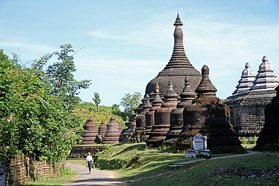 Ratanabon
 -
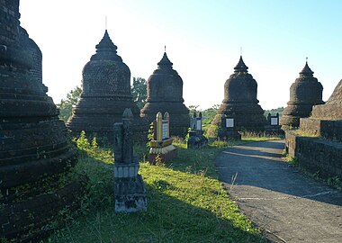 Pagodas in Mrauk U


Burmese conquest


The
Rakhine rebellions were suppressed. Many Rakhine Buddhists fled by sea to the Barisal region of Bengal, where their descendants continue to live today.[39] It is also likely that Arakanese Muslims became dispersed across Burma and Bengal as either deportees or refugees due to the conflict. Arakan experienced a demographic vacuum as a result of the Burmese conquest. There were several uprisings against Burmese rule, including a rebellion by Chin Bya in 1811.[40] The uprisings caused recurrent Burmese raids into British India, which led to the First Anglo-Burmese War.
British Empire


The Burmese Empire ceded Arakan to the

During British rule, Arakan Division was one of the largest rice exporters in the world.[41] Arakan was the pioneer of the rice industry in British Burma. The emergence of Burma as a global rice exporter in the 20th century can be traced to Arakan. As one of the earliest regions to be conquered by the British, Arakan saw the removal of export restrictions imposed by the Burmese Empire. Rice was exproted to Bengal and beyond.[42] Akyab (now Sittwe), the divisional capital of Arakan, was located in proximity to the Chittagong Division of British Bengal. In 1840, Akyab exported 74,500 tons of rice valued at an estimated 1.2 million rupees. In 1855, Akyab exported 162,000 tons of rice valued at an estimated 3 million rupees. The growth in rice exports was driven by the expansion of farmland – by clearing out jungles and cultivating paddy fields.
| Period | In Thousands of Tons |
|---|---|
| 1865 to 1870 | 308 |
| 1871 to 1875 | 484 |
| 1876 to 1880 | 557 |
| 1881 to 1885 | 707 |
| 1886 to 1890 | 657 |
Agriculturalists from
In 1869, Muslims constituted 12.24% of the population in Arakan. In 1931, they constituted 25.56%. In the divisional capital Akyab, the share of the Muslim population increased from 20.67% in 1869 to 38.41% in 1931. The British administration considered Chittagonian migration from Bengal as a key factor in the growth of the Muslim population. The colonial government encouraged Chittagonian migration as part of its policy to expand the rice economy in Arakan. The northern part of Arakan received the largest influx of settlers. The township of Naaf (now Maungdaw), which bordered Chittagong Division, became an extension of farmlands in
World War II

During
The division's seaport and capital Akyab were dominated by
Burmese independence
Arakan became one of the
In 1982, the Burmese
Rakhine-led groups like the
Demographics
The people of Arakan have historically been called the Arakanese.
The
Arakan Division had the largest percentage of Indians in
See also
References
- ^ Columbia Encyclopedia, s.v. "Rakhine State".
- ^ a b c "The long history of the Rohingyas that Myanmar refuses to acknowledge". 29 September 2021.
- ^ a b "Arakanese | Definition, Location, & Ancient Kingdom | Britannica".
- ^ Sheikh, Nur-Mohammad (19 March 2023). "The return of the Arakanese Muslims: Could this be the beginning of a resolution to the Rohingya crisis?". Dhaka Tribune. Archived from the original on 13 Feb 2024. Retrieved 13 Feb 2024.
- ^ Lieut.-General Sir Arthur P. Phayre G.C.M.G, K.C.S.I., AND C.B., ‘Chapter V: Arakan’, History of Burma including Burma Proper, Pegu, Taungu, Tenasserim, and Arakan: From the Earliest Time to the End of the First War with British India (2nd edn, 1967). 42
- ISBN 978-81-206-0391-2.
- ^ Thomas Bankes; Edward Warren Blake; Alexander Cook; Thomas Lloyd (1800). A New, Royal, and Authentic System of Universal Geography, Ancient and Modern: Including All the Late Important Discoveries ... and a Genuine History and Description of the Whole World ... Together with a Complete History of Every Empire, Kingdom, and State ... to which is Added a Complete Guide to Geography, Astronomy, the Use of the Globes, Maps ... p. 247.
- ISBN 978-981-230-439-1.
- ^ Jacques Leider, Territorial Dispossession and Persecution in North Arakan (Rakhine), 1942–43 (2020) <https://www.toaep.org/pbs-pdf/101-leider/> accessed 5 August 2021.
- ^ a b The Editors (1959-08-21). "Arakan | state, Myanmar". Britannica.com. Retrieved 2017-09-18.
{{cite web}}:|author=has generic name (help) - ^ Jacques Leider, 'Arakan's Ascent During The Mrauk U Period', Recalling Local Pasts: Autonomous History in Southeast Asia (Silkworm Books 2002). 58
- ^ Beniison, J.J (1933). Census of India, 1931: Burma Part I – Report. Rangoon: Office of Superintendent, Government Printing and Stationery, Burma. p. 149.
- ^ ISBN 978-0-313-35725-1.
- ^ D. G. E Hall, A History of South East Asia, New York, 1968, P. 389.
- ISBN 978-0-19-726303-7.
- ISBN 9788131304051. Retrieved 2017-09-17.
- ^ Pamela Gutman and Zaw Min Yu, Burma's Lost Kingdoms: Splendours of Arakan (Orchid Press 2001). 3
- ^ a b Pamela Gutman and Zaw Min Yu, Burma's Lost Kingdoms: Splendours of Arakan (Orchid Press 2001). p. 8
- ^ "Harikela – Banglapedia". En.banglapedia.org. 2014-05-05. Retrieved 2017-09-17.
- ^ “Three medallions above the head contain sacred syllables in proto-Bengali script”. Pamela Gutman and Zaw Min Yu, ‘Vesali’, Burma's Lost Kingdoms: Splendours of Arakan (Orchid Press 2001). p. 57
- ^ Pamela Gutman and Zaw Min Yu, Burma's Lost Kingdoms: Splendours of Arakan (Orchid Press 2001). p. 3
- ISBN 978-0-674-72846-2.
- ^ "The thoroughfare of Islam – Dhaka Tribune". www.dhakatribune.com.
- ISBN 978-0-7864-8189-7.
- ISBN 978-981-283-357-0.
- ^ Jacques Leider, 'Arakan's Ascent During The Mrauk U Period', Recalling Local Pasts: Autonomous History in Southeast Asia (Silkworm Books 2002). 63
- ^ a b In the Arakanese tradition, we find that “The restored king agreed to be tributary to the king of Bengal”.” Mohammad Ali Chowdhury, ‘Bengal-Arakan Relations at the turn of the 15th century’, Bengal-Arakan Relations (1430–1666 A.D.) (1st edn, 2004). 32
- ^ a b Bengal-Arakan Relations (1430–1666 A.D.) by Mohammed Ali Chowdhury
- ^ Jacques Leider, 'Arakan's Ascent During The Mrauk U Period', Recalling Local Pasts: Autonomous History in Southeast Asia (Silkworm Books 2002). 55
- ^ Jacques Leider, 'Arakan's Ascent During The Mrauk U Period', Recalling Local Pasts: Autonomous History in Southeast Asia (Silkworm Books 2002). 79
- ^ Jacques Leider, 'Arakan's Ascent During The Mrauk U Period', Recalling Local Pasts: Autonomous History in Southeast Asia (Silkworm Books 2002). 81
- ^ Yegar 2002, pp. 23–24.
- ^ a b Yegar 2002, p. 24.
- ^ Aye Chan 2005, p. 398.
- ISBN 978-1-78374-102-1.
- ^ "The Hidden City of Myanmar".
- ISBN 978-981-4749-83-1.
- ^ Aye Chan 2005, p. 399.
- ^ "Rakhain, the – Banglapedia".
- ^ "Burma/Bangladesh: Burmese Refugees in Bangladesh – Historical Background".
- ^ Georg Hartwig (1863). The Tropical World: a Popular Scientific Account of the Natural History of the Animal and Vegetable Kingdoms in the Equatorial Regions. Longman, Green, Longman, Roberts, and Green. p. 159.
- ^ Cheng Siok Hwa, 'The Development of the Burmese Rice Industry in the Late Nineteenth Century' (1965) 6 Journal of Southeast Asian History. 69
- Journal of Southeast Asian History.
- ^ Cheng Siok Hwa, 'The Development of the Burmese Rice Industry in the Late Nineteenth Century' (1965) 6 Journal of Southeast Asian History. 74–75
- ^ Jacques Leider, 'The Chittagonians In Colonial Arakan: Seasonal And Settlement Migrations', Colonial Wrongs and Access to International Law (Torkel Opsahl Academic EPublisher 2020).
- ISBN 978-0-674-01748-1.
- ^ Yegar 1972, p. 10.
- ^ Eberhard, David M.; Simons, Gary F.; Fennig, Charles D., eds. (2019). "Myanmar – Languages". Ethnologue. SIL International.
- ^
Robert H. Taylor (1987). The State in Burma. C. Hurst & Co. Publishers. pp. 126–127. ISBN 978-1-85065-028-7.
Sources
- Aye Chan (Autumn 2005). "The Development of a Muslim Enclave in Arakan (Rakhine) State of Burma (Myanmar)" (PDF). SOAS Bulletin of Burma Research. 3 (2). Archived from the original (PDF) on 12 July 2013. Retrieved 11 September 2017.
- Yegar, Moshe (1972). Muslims of Burma (PDF). Wiesbaden: Verlag Otto Harrassowitz.
- ISBN 978-0-7391-0356-2.
External links
 Media related to Arakan at Wikimedia Commons