
Argentine Declaration of Independence
This article includes a list of general references, but it lacks sufficient corresponding inline citations. (July 2011) |
| History of Argentina |
|---|
 |
|
|
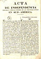
What today is commonly referred as the Independence of
Causes
The 1810
When the Spanish monarchy resumed its functions in 1814, Spain was determined to recover control over its
, and seriously threatened the United Provinces from the north.On April 15, 1815, a revolution ended the mandate of
Development
The Congress was inaugurated in the city of Tucumán, with 33 deputies. The presidency of the Congress would be rotated monthly. Because the Congress had the freedom to choose topics to debate, endless discussions ensued.
The voting finally ended on July 9 with a declaration of independence. The Declaration pointed to the circumstances in Europe of the past six years—
The congress continued its work in
The house where the declaration was adopted has been rebuilt and is now a museum and monument: the
Signatories of the declaration
- San Juan, President
- Mariano Boedo, Deputy for Salta, Vice-president
- José Mariano Serrano, Deputy for Charcas (present-day Bolivia), Secretary
- Juan José Paso, Deputy for Buenos Aires, Secretary
- Dr. Antonio Sáenz, Deputy for Buenos Aires
- Dr. José Darragueira, Deputy for Buenos Aires
- Friar Cayetano José Rodríguez, Deputy for Buenos Aires
- Dr. Pedro Medrano, Deputy for Buenos Aires
- Dr. Manuel Antonio Acevedo, Deputy for Catamarca
- Dr. José Ignacio de Gorriti, Deputy for Salta
- Dr. José Andrés Pacheco de Melo, Deputy for Chibchas (present-day Bolivia)
- Dr. Teodoro Sánchez de Bustamante, Deputy for Jujuy
- Córdoba
- Tomás Godoy Cruz, Deputy for Mendoza
- Dr. Pedro Miguel Aráoz, Deputy for Tucumán
- Dr. Esteban Agustín Gazcón, Deputy for Buenos Aires
- Pedro Francisco de Uriarte, Deputy for Santiago del Estero
- Pedro León Gallo, Deputy for Santiago del Estero
- Pedro Ignacio Rivera, Deputy for Mizque (present-day Bolivia)
- Dr. Mariano Sánchez de Loria, Deputy for Charcas (present-day Bolivia)
- Dr. José Severo Malabia, Deputy for Charcas (present-day Bolivia)
- Dr. La Rioja
- Lic. Córdoba
- Dr. José Colombres, Deputy for Catamarca
- Dr. José Ignacio Thames, Deputy for Tucumán
- Friar San Juan
- Córdoba
- Dr. Juan Agustín Maza, Deputy for Mendoza
- Tomás Manuel de Anchorena, Deputy for Buenos Aires
Recognition of independence
- Kingdom of Hawaiʻi: 1818
- Portugal: 1821
- United States of America: 1822
- United Kingdom: December 15, 1823
- France: 1830
- Denmark: 1841
- United Kingdoms of Sweden and Norway: 1847
- Spain: April 29, 1857
Translations
The Declaration of Independence of the
-
 Quechua version
 -
 Aymara version


See also
- Argentine War of Independence
- Congress of Tucumán
- United Provinces of South America
References
- 9 de Julio de 1816: Declaración de la Independencia (in Spanish)
- Act of Independence – Spanish Wikisource
- ^ The Argentine Littoral provinces Santa Fé, Entre Ríos and Corrientes, along with the Eastern Province (present-dayUruguay)
- ^ Una Declaración de Independencia en aymara (in Spanish)


