
Arnhem
Arnhem | |
|---|---|
municipality | |
|
UTC+2 (CEST) | |
| Postcode | 6800–6846 |
| Area code | 026 |
| Website | www |
 | |
| Click on the map for a fullscreen view | |


Arnhem (Dutch:
Arnhem is home to the
Early history

The oldest archeological findings of human activity around Arnhem are two firestones of about 70,000 years ago. These come from the
The earliest settlement in Arnhem dates from 1500 BC, of which traces have been found on the Hoogkamp, where the Van Goyenstraat is currently located. In the inner city, around the Sint-Jansbeek, traces of settlement have been found from around 700 BC, while the first traces south of the Rhine have been found dating to around 500 BC, in the Schuytgraaf.
Though the early tracks of settlements did show that the early residents of Arnhem descended from the forests on the hills, Arnhem was not built on the banks of the river Rhine, but a little higher along the Sint-Jansbeek. Arnhem arose on the location where the road between Nijmegen and Utrecht and Zutphen split. Seven streams provided the city with water, and only when the flow of the Rhine was changed in 1530, was the city located on the river.
Middle Ages
Arnhem was first mentioned as such in 893 as Arneym or Arentheym. In 1233, Count
16th and 17th century
In 1514,
18th and 19th century

From 1795 to 1813, it was reoccupied by the French, by both revolutionary and imperial forces.
In the early 19th century, the former fortifications were almost completely dismantled, to give space for town expansion. The Sabelspoort (Sabresgate) is the only remaining part of the medieval walls.
In the 19th century, Arnhem was a genteel resort town famous for its picturesque beauty. It was known as "het Haagje van het oosten" (The Little Hague of the East), mainly because a number of rich former sugar barons or planters from the Indies settled there, as they did in The Hague. Even now the city is famous for its parks and greenery. The urbanization in the north on hilly terrain is also quite unusual for the Netherlands.
World War II
During the German occupation (World War II), the occupiers operated a subcamp of the Herzogenbusch concentration camp in the city.[8]

During
Glider infantry and paratrooper units were landed into the area on 17 September and later. The bulk of the force was dropped rather far from the bridge and never met their objective. A small element of the British 1st Airborne, the 2nd Parachute Battalion under Lieutenant Colonel John D. Frost, managed to make its way as far as the bridge but was unable to secure both sides. The British troops encountered stiff resistance from the German 9th and 10th SS Panzer Divisions, which had been stationed in and around the city.

The British force at the bridge eventually ran out of ammunition and was captured on 21 September, and a full withdrawal of the remaining forces was made on 26 September. These events were dramatized in the 1977 movie
The current bridge is the third almost-identical bridge built at the same spot. The
Liberation
A second battle of Arnhem took place in April 1945 when the city was liberated by the British 49th (West Riding) Infantry Division fighting as part of the First Canadian Army. The inhabitants of the city, who had been forcibly evacuated by the Germans during and after the battle, returned in the summer of 1945. The reconstruction of Arnhem took until 1969 to finally be completed.
Just outside Arnhem, in the town of Oosterbeek the Commonwealth War Graves Commission built the Arnhem Oosterbeek War Cemetery which contains the graves of most of those killed during the September landings, and many of those killed in later fighting in the area.
The city also hosted the 1980 Summer Paralympics.[9]
Geography

Neighbourhoods
The municipality of Arnhem consists of the city of Arnhem and the following surrounding suburbs and former villages:
- Elden, Netherlands (former village, now totally surrounded by other Arnhem neighbourhoods)
- Schaarsbergen
Arnhem consists of three districts (stadsdelen) and 24 neighbourhoods (wijken). Each neighbourhood has a number which corresponds to its postal code.
- Arnhem Centrum (Binnenstad)
- Arnhem-North (Spijkerkwartier, Arnhemse Broek, Presikhaaf-West, Presikhaaf-East, St. Marten/Sonsbeek-Zuid, Klarendal, Velperweg, Alteveer en Cranevelt, Geitenkamp, Monnikenhuizen, Burgemeesterswijk/Hoogkamp, Heijenoord/Lombok, Klingelbeek)
- Arnhem-South (Malburgen-West, Malburgen-East (North), Malburgen-East (South), De Laar East/West, Vredenburg/Kronenburg, Elderveld, Rijkerswoerd, Schuytgraaf)
Neighbouring villages
The outlying areas of the following villages are bordering the municipality of Arnhem directly, which means among others that in many a case a considerable number of their inhabitants originate from Arnhem.
Proximity of border with Germany
The city lies approximately 15 kilometers from the border with Germany, and to some extent the westernmost villages in the municipality of Elten, Germany, function as dormitories for people who work in the Dutch city of Arnhem in part due to the immigration of Dutch people from the region that were attracted by the lower house pricing just across the border.
Climate
Arnhem features the same climate (Cfb, oceanic climate) as all of the Netherlands; however, its location on the foothills of the Veluwe, the largest forest in the Netherlands, contributes to some higher precipitation values.
| Climate data for Deelen, Arnhem (1991−2020 normals, extremes 1953−present) | |||||||||||||
|---|---|---|---|---|---|---|---|---|---|---|---|---|---|
| Month | Jan | Feb | Mar | Apr | May | Jun | Jul | Aug | Sep | Oct | Nov | Dec | Year |
| Record high °C (°F) | 14.5 (58.1) |
19.5 (67.1) |
24.6 (76.3) |
29.4 (84.9) |
31.9 (89.4) |
34.2 (93.6) |
39.2 (102.6) |
37.2 (99.0) |
32.7 (90.9) |
26.4 (79.5) |
19.5 (67.1) |
15.2 (59.4) |
39.2 (102.6) |
| Mean daily maximum °C (°F) | 5.4 (41.7) |
6.5 (43.7) |
10.3 (50.5) |
14.9 (58.8) |
18.6 (65.5) |
21.3 (70.3) |
23.4 (74.1) |
23.0 (73.4) |
19.4 (66.9) |
14.5 (58.1) |
9.3 (48.7) |
6.0 (42.8) |
14.4 (57.9) |
| Daily mean °C (°F) | 2.9 (37.2) |
3.2 (37.8) |
5.9 (42.6) |
9.6 (49.3) |
13.3 (55.9) |
16.1 (61.0) |
18.1 (64.6) |
17.7 (63.9) |
14.5 (58.1) |
10.5 (50.9) |
6.4 (43.5) |
3.5 (38.3) |
10.1 (50.2) |
| Mean daily minimum °C (°F) | 0.0 (32.0) |
-0.0 (32.0) |
1.6 (34.9) |
3.8 (38.8) |
7.5 (45.5) |
10.4 (50.7) |
12.6 (54.7) |
12.3 (54.1) |
9.8 (49.6) |
6.6 (43.9) |
3.3 (37.9) |
0.9 (33.6) |
5.7 (42.3) |
| Record low °C (°F) | −24.2 (−11.6) |
−23.2 (−9.8) |
−17.0 (1.4) |
−9.4 (15.1) |
−4.5 (23.9) |
−0.9 (30.4) |
2.0 (35.6) |
2.4 (36.3) |
−0.9 (30.4) |
−6.5 (20.3) |
−9.9 (14.2) |
−18.4 (−1.1) |
−24.2 (−11.6) |
| Average precipitation mm (inches) | 79.5 (3.13) |
63.7 (2.51) |
60.7 (2.39) |
43.8 (1.72) |
62.9 (2.48) |
69.1 (2.72) |
86.5 (3.41) |
83.9 (3.30) |
73.8 (2.91) |
73.3 (2.89) |
79.5 (3.13) |
91.3 (3.59) |
868.0 (34.17) |
| Average relative humidity (%)
|
88.8 | 85.5 | 80.0 | 72.8 | 72.5 | 74.5 | 75.7 | 77.5 | 82.5 | 86.6 | 90.9 | 90.8 | 81.5 |
| Mean monthly sunshine hours | 62.7 | 86.7 | 135.8 | 181.6 | 205.1 | 196.2 | 203.2 | 188.3 | 148.7 | 115.9 | 66.7 | 53.5 | 1,644.4 |
| Percent possible sunshine | 24.2 | 30.8 | 36.8 | 43.6 | 42.2 | 39.3 | 40.4 | 41.4 | 39.0 | 35.0 | 25.0 | 22.0 | 35.0 |
| Source: Royal Netherlands Meteorological Institute[10][11] | |||||||||||||
Demographics
Inhabitants by nationality
| Arnhem residents by ethnic background (1 January 2023)[12] | |||
|---|---|---|---|
| Country | 2023 | ||
| 64.2% | |||
| 8.9% | |||
| 5.2% | |||
| 3.4% | |||
| 2.4% | |||
| 2.1% | |||
| 2.1% | |||
| Other non-western | 11.7% | ||
Places of interest

The Grote Kerk (St. Eusebius' Church), built 1452–1560, lost most of its tower during World War II, of which a part has been reconstructed to a modern design and opened in 1964. Officially the tower is not part of the church and is owned by the municipality.
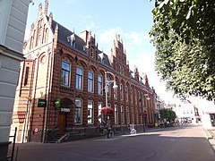
The house of Maarten van Rossum, a general serving Duke Charles van Gelre, has been the town hall since 1830: The satyrs in its Renaissance ornamentation earned it the name Duivelshuis (devil's house). The Netherlands Open Air Museum is located outside the city. It includes antique houses, farms, factories, and windmills from different parts of the Netherlands. Two other windmills stand in Arnhem itself, De Hoop and De Kroon.
The
The KEMA Toren (formerly known as SEP Control Tower) is the highest structure of the town. It is a 140-m-high TV tower.
Parks
-
 Sonsbeek Park (Urban park)
 -
 Zypendaal Park
 -
 Veluwezoom National Park
 -
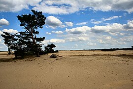 Hoge Veluwe National Park


Museums in and around Arnhem
-
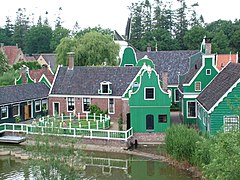 Netherlands Open Air Museum
 -
 Airborne Museum 'Hartenstein'
 -
 Gemeentemuseum
 -
 Museum Bronbeek


Buildings and locations
-
 Musis Sacrum
 -
 Arnhem Centrum
 -
 Central Station
 -
 Burgers Zoo


Events

- Airborne Commemoration (17–26 September)
- World Statues Festival (The World Championship of Living Statues)
- Sonsbeek Theater Avenue
- Free Your Mind Festival
- Dancetour
- 8Bahn
- De Rabo Bridge to Bridge (Marathon)
- UITboulevard (Cultural Festival)
- Sprookjesfestival (Fairy tale Festival)
- King's Day
- Sinterklaas
- hoogte 80
Sport


The National Sports Centre Papendal is the national sports development centre of the Netherlands, located in Arnhem. The first event held at Papendal was the 1980 Summer Paralympics, from 21 June to 5 July. However the site was formally adopted and developed from 1993, after the merger of the Dutch National Olympic Committee (NOC) and the Nederlandse Sport Federatie (NSF).
In preparation for the
Since January 2013 Sports Centre Papendal officially split from NOC * NSF and thus as organization demerges. This split offers Sports Centre Papendal many commercial benefits. There are facilities for various sports, including athletics, cycling and more.
Sport in the city is principally focussed on its association football club
Transport

Arnhem has had a main central railway station since 1845 –
Until 2016, there were also NS International trains to other destinations abroad, with some coaches going as far as Moscow.
The intercity lines provide direct connections to Utrecht, Nijmegen and Zutphen. It is also the terminus for several local railway services. Arnhem has three other stations, namely Arnhem Velperpoort (since 1953), Arnhem Presikhaaf (since 1969) and Arnhem Zuid (since 2005).
Notable people
- Karel Aalbers (1949), Business man and club president
- Truus van Aalten (1910–1999), actress
- Afro Brothers(2016), electronic/urban DJ duo
- Blaudzun (1974), singer-songwriter
- Marion Bloem (1952), writer and film maker
- Hetty Blok (1920–2012), cabaret artist, singer, and actress
- Edmond Classen (1938–2014), actor
- Ien Dales (1931–1994), politician of the Labour Party (PvdA)
- Esmée Denters (1988), singer and YouTube celebrity
- Eva Duldig (born 1938), Austrian-born Australian and Dutch tennis player, author
- Henk Guth (1921-2002), artist
- Jan van Hooff (1936), biologist
- Aarnoud van Heemstra (1871–1957), politician and maternal grandfather of Audrey Hepburn
- Kenny van Hummel (1982), bicycle racer
- Rudolf Jansen (1940–2024), pianist
- Tania de Jong, Dutch-born Australian soprano and entrepreneur; daughter of Eva Duldig
- Ferdi Kadıoğlu, (1999), Dutch-born Turkish player
- Antonie Kamerling (1966–2010), actor and musician
- Herman Koch (1953), writer and actor
- Hendrik Lorentz (1853–1928), physicist and Nobel Prize laureate
- Goos Meeuwsen (1982), circus artist
- Leo Peelen (1968–2017), track cyclist
- Estavana Polman (1992), handballer
- Joran van der Sloot (1987), convicted murderer
- Mart Smeets (1947), radio and television host, and writer
- Saar de Swart (1861–1951), sculptor
- Rik Toonen (1954), water polo player, bronze medalist at the 1976 Summer Olympics
- Linda Wagenmakers (1975), singer and voice actress
Facts and figures
- Arnhem is the name of a march composed by A.E. Kelly.
- Arnhem Land in Australia is named after the VOC-ship Arnhem.
- Theirs is the Glory (a.k.a. Men of Arnhem), is a 1946 British war film about the British 1st Airborne Division's involvement in the Battle of Arnhem (17 to 25 September 1944) during Operation Market Garden in the Second World War. Another film, A Bridge Too Far, tells the story of the failure of Operation Market Garden in Arnhem.
Twin towns – sister cities
 Coventry, England, United Kingdom
- Croydon, England, United Kingdom
 Gera, Germany
 Hradec Králové, Czech Republic
 Kimberley, South Africa
 Villa El Salvador, Peru
 Airdrie, Scotland, United Kingdom
See also
References
- ^ "Ahmed Marcouch (burgemeester)" [Ahmed Marcouch (mayor)] (in Dutch). Gemeente Arnhem. Archived from the original on 22 April 2016. Retrieved 10 June 2014.
- ^ "Kerncijfers wijken en buurten 2020" [Key figures for neighbourhoods 2020]. StatLine (in Dutch). CBS. 24 July 2020. Retrieved 19 September 2020.
- ^ "Postcodetool for 6811DG". Actueel Hoogtebestand Nederland (in Dutch). Het Waterschapshuis. Retrieved 10 June 2014.
- ^ "Bevolkingsontwikkeling; regio per maand" [Population growth; regions per month]. CBS Statline (in Dutch). CBS. 1 January 2021. Retrieved 2 January 2022.
- ^ "Bevolkingsontwikkeling; Regionale kerncijfers Nederland" [Regional core figures Netherlands]. CBS Statline (in Dutch). CBS. 1 January 2020. Retrieved 8 March 2021.
- ^ "Arnhem | Netherlands | Britannica". May 2023.
- ^ "Arnhem | Netherlands | Britannica". May 2023.
- ISBN 978-0-253-35328-3.
- ^ "Arnhem 1980".
- ^ "Weerstatistieken Deelen". Royal Netherlands Meteorological Institute. Retrieved 25 June 2022.
- ^ "Klimaatviewer 1991-2020". Royal Netherlands Meteorological Institute. Retrieved 25 June 2022.
- ^ "Mosaic3". arnhem.incijfers.nl. Retrieved 25 April 2023.
- ^ "Over ons (About us)" (in Dutch). NOC*NSF. Retrieved 4 December 2010.
- ^ Ollie Williams (25 March 2011). "Building a London 2012 venue - in a Dutch forest". BBC Sport. Retrieved 25 March 2011.
- ^ "Travel by bus or rail with a KLM ticket Archived 29 October 2016 at the Wayback Machine." KLM. Retrieved 29 October 2016.
- ^ "Arnhem" (PDF). amazing-holland.nl (in Dutch). Amazing Holland. p. 11. Retrieved 21 July 2021.
External links
- Municipality Official website (English version)
- VVV Arnhem Archived 12 April 2018 at the Wayback Machine Tourist Office (English version)
- Commonwealth War Graves Commission The CWGC Page for the cemetery.
Places adjacent to Arnhem | |
|---|---|

| International | |
|---|---|
| National | |
| Geographic | |
| Other | |