
Assateague Island
 Aerial view of Assateague Island with Ocean City, Maryland in the background | |
 Assateague Island  Assateague Island  Assateague Island | |
| Geography | |
|---|---|
| Location | Atlantic Ocean |
| Coordinates | 37°58′35.07″N 75°18′17.12″W / 37.9764083°N 75.3047556°W |
| Area | 63 km2 (24 sq mi) |
| Administration | |
United States | |
| Additional information | |
| Official website | |


Assateague Island is a 37-mile (60 km) long barrier island located off the eastern coast of the Delmarva Peninsula facing the Atlantic Ocean.[1] The northern two-thirds of the island is in Maryland, and the southern third is in Virginia.
The Maryland section contains the majority of
History
Like all
The island was once connected to the southern end of
Between 1933 and the early 1960s,
Parks and refuge
The entirety of Assateague Island is owned and operated by three different agencies: the NPS, Maryland State Parks, and United States Fish and Wildlife Service. All of the land on the island north of the Maryland-Virginia state line is the Assateague Island National Seashore, with the exception of the smaller Assateague State Park. The national seashore was established in 1965 to preserve the barrier island and surrounding waters, and provide recreational opportunities.
All of the island south of the state border in Virginia is the Chincoteague National Wildlife Refuge, with the exception of a one-mile stretch of land including the recreational beach and interpretive facilities managed by the NPS.[11] The Refuge was established in 1943 to provide habitat for migratory birds, primarily snow geese.[12] The U.S. Geological Survey has initiated studies aimed at mitigating the potential sea-level rise on this barrier island complex.[13]
Human use of the island
The National Park Service allows off-road vehicles with permits in certain areas.[14] Car camping sites are available in both the National Seashore and Assateague State Park by reservation.[15][16] Backcountry sites are also available from the National Seashore.[17] There is no camping available from the Chincoteague National Wildlife Refuge. Pets are prohibited in all areas except certain parts of the National Seashore and parts of the state park. Kayak touring is a popular way to see the wildlife, especially on the calmer bay side. Summer months are known for heavy mosquito populations, particularly on the bay side.[18]
Assateague State Park comprises almost 800 acres (3.2 km2) and lies in Maryland within the National Seashore. The state park is the most developed area on the island with 350 campsites. Most of the water around the island is within the boundaries of the national seashore. The island has a land area of 24.4 square miles (63 km2) and has no resident population in either Maryland or Virginia, though a few retained property rights until 2006. These were mainly hunting camps.
Fauna
Large populations of birds inhabit the island, including American oystercatcher, great blue heron, and snowy egret. There are over 320 species that are known to inhabit the island during some portion of the year. These include gulls, terns, and other shorebirds along with raptors, waterbirds, and waterfowl. The piping plover is a threatened species that nests on Assateague.[19][20]
The
The Maryland and Virginia horses are kept apart by fencing at the border between the two states. Though commonly called "wild," these horses had domesticated ancestors. Legend states their ancestors were survivors of a Spanish galleon that shipwrecked along the coast, and DNA evidence indicates the modern population includes the closest living descendants of Spanish horses brought to the Americas in the early 1500s.
The Maryland horses are owned and managed by the NPS, who have carefully followed the population over generations. In Virginia, the Chincoteague ponies are owned by the Chincoteague Volunteer Fire Company. Once a year in July, the local "salt water cowboys" round them up and sort a number of animals to be removed from the island, which are put up for auction on Pony Penning Day.[21][12]
To keep their numbers under control on the Maryland side, a federal contraceptive program has been in place since 1994. In Virginia, the Pony Penning Days auction keeps the horse population at levels required by agreement with the Chincoteague National Wildlife Refuge.
Climate
Assateague Island has a humid subtropical climate and is the only part of Maryland with the southern tip of the Delmarva peninsula in hardiness Zone 8a.[citation needed]
| Climate data for Assateague, Maryland, 1991–2020 normals | |||||||||||||
|---|---|---|---|---|---|---|---|---|---|---|---|---|---|
| Month | Jan | Feb | Mar | Apr | May | Jun | Jul | Aug | Sep | Oct | Nov | Dec | Year |
| Mean daily maximum °F (°C) | 46.7 (8.2) |
48.4 (9.1) |
53.7 (12.1) |
62.9 (17.2) |
71.7 (22.1) |
80.9 (27.2) |
86.1 (30.1) |
85.4 (29.7) |
80.3 (26.8) |
71.7 (22.1) |
60.4 (15.8) |
51.7 (10.9) |
66.7 (19.3) |
| Daily mean °F (°C) | 38.6 (3.7) |
40.5 (4.7) |
45.6 (7.6) |
54.0 (12.2) |
62.8 (17.1) |
72.0 (22.2) |
77.2 (25.1) |
76.6 (24.8) |
72.3 (22.4) |
62.5 (16.9) |
51.3 (10.7) |
43.4 (6.3) |
58.1 (14.5) |
| Mean daily minimum °F (°C) | 30.5 (−0.8) |
32.6 (0.3) |
37.4 (3.0) |
45.0 (7.2) |
53.9 (12.2) |
63.1 (17.3) |
68.2 (20.1) |
67.7 (19.8) |
64.4 (18.0) |
53.4 (11.9) |
42.3 (5.7) |
35.0 (1.7) |
49.5 (9.7) |
| Average precipitation inches (mm) | 3.39 (86) |
3.29 (84) |
4.24 (108) |
3.39 (86) |
3.20 (81) |
3.50 (89) |
4.21 (107) |
4.20 (107) |
4.50 (114) |
3.94 (100) |
3.02 (77) |
4.00 (102) |
44.88 (1,140) |
| Average snowfall inches (cm) | 1.8 (4.6) |
1.0 (2.5) |
0.4 (1.0) |
0.0 (0.0) |
0.0 (0.0) |
0.0 (0.0) |
0.0 (0.0) |
0.0 (0.0) |
0.0 (0.0) |
0.0 (0.0) |
0.0 (0.0) |
0.2 (0.51) |
3.4 (8.6) |
| Average precipitation days (≥ 0.01 in) | 10.1 | 9.1 | 11.0 | 10.3 | 10.4 | 9.4 | 9.4 | 8.2 | 7.9 | 8.4 | 7.7 | 10.7 | 112.6 |
| Average snowy days (≥ 0.1 in) | 0.6 | 0.7 | 0.4 | 0.0 | 0.0 | 0.0 | 0.0 | 0.0 | 0.0 | 0.0 | 0.0 | 0.3 | 2.0 |
| Source: NOAA[23] | |||||||||||||
Gallery
-
 Chincoteague National Wildlife Refuge with lighthouse in distance
 -
 Assateague Island waterways
 -
 Humans and horses are often brought into proximity on the island.
 -
 Egrets in Assateague's marshes
 -
 Feral horses on Assateague Island
 -
 Deer on Assateague
 -
 Saltwater cowboys round up ponies on Assateague and herd them down the beach at sunrise.
 -
 Swimming from Assateague for Pony Penning Day on Chincoteague
 -
 Winter 2022 on Assateague Island
 -
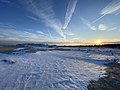 Snow blankets Assateague Island in January 2022
 -
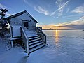 A winter scene on Assateague Island in January 2022


References
- National Geographic, Index (January–June 1980), vol 157 (June 1980): 812.
- ^ Turner, John and Jay Kirkpatrick. Field Guide to the Assateague Ponies. Toledo, Ohio 1988.
- ^ GMCO Maps & Charts. GMCO's Fishing & Recreation Map of Chincoteague-Assateague, Virginia, 2003.
- ^ a b c Mackintosh, Barry. "Assateague Island administrative history" History Division, National Park Service. 1982. Accessed December 3, 2010 Archived November 7, 2012, at the Wayback Machine
- ^ "Park Quest: Assateague State Park". Maryland Department of Natural Resources. 2009. Archived from the original on 16 June 2011.
- NOAA (4 January 2021). "What is a barrier island?". NOAA National Ocean Service. Retrieved 27 July 2022.
- ^ a b c Williams, Jeff. "USGS Research Contributes to Assateague Island Restoration—Mitigating 70 Years of Coastal Erosion Due to Ocean City Inlet Jetties". Sound Waves November, 2002. Accessed online December 3, 2010.
- ^ National Parks Conservation Association. State of the Parks: Assateague Island National Seashore, p. 19. August 2007. Accessed online December 3, 2010. Archived February 15, 2010, at the Wayback Machine
- Baltimore Sun. Archived from the originalon July 28, 2012. Retrieved December 3, 2010.
- ^ Kobell, Rona (December 3, 2014). "Last Cedar Island house slips into sea". Bay Journal. Archived from the original on December 17, 2014.
- ^ "Basic Information". Assateague Island National Seashore. National Park Service. Retrieved 13 May 2023.
- ^ a b "About Us". Chincoteague National Wildlife Refuge. U.S. Fish and Wildlife Service. Retrieved 13 May 2023.
- ^ Masterson, John P. Development of a Numerical Model to Simulate Groundwater Flow in the Shallow Aquifer System of Assateague Island, Maryland and Virginia. Reston, Va.: United States Geological Survey, 2013.
- ^ "Over Sand Vehicle (OSV) Use". Assateague Island National Seashore. National Park Service. Retrieved 13 May 2023.
- ^ "Camping At Assateague". Assateague Island National Seashore. National Park Service. Retrieved 13 May 2023.
- ^ "Camping". Assateague State Park. Maryland Department of Natural Resources. Retrieved 13 May 2023.
- ^ "Backcountry camping". Assateague Island National Seashore. National Park Service. Retrieved 13 May 2023.
- ^ "Safety". Assateague Island National Seachore. National Park Service. Retrieved 13 May 2023.
- ^ United States Fish and Wildlife Service. "Species Profile, Piping Plover (Charadrius melodus)". USFWS. Retrieved 2014-01-16.
- ^ "Birds". Assateague Island National Seashore. National PArk Service. Retrieved 13 May 2023.
- ^ a b c "Assateague's Wild Horses". Assateague Island National Seashore. National Park Service. Retrieved 13 May 2023.
- ^ "U.S. Climate Normals Quick Access – Station: Assateague, MD". National Oceanic and Atmospheric Administration. Retrieved February 9, 2023.
External links
 Media related to Assateague Island at Wikimedia Commons
 Assateague Island travel guide from Wikivoyage
- Assateague Island National Seashore
- Assateague State Park
- Assateague photos
- Philip E. Hartman papers at the University of Maryland library contain letters, reports, and publications, which document environmental activities relating to Assateague Island.
Places adjacent to Assateague Island | |
|---|---|
| International | |
|---|---|
| National | |
| Other | |