
Astoria–Ditmars Boulevard station
Astoria–Ditmars Blvd Q100 (at 20th Avenue) | ||||||||||||||||||||||||||||||||||||||||||||||||||||||||||||||||||||||||||||||||||
|---|---|---|---|---|---|---|---|---|---|---|---|---|---|---|---|---|---|---|---|---|---|---|---|---|---|---|---|---|---|---|---|---|---|---|---|---|---|---|---|---|---|---|---|---|---|---|---|---|---|---|---|---|---|---|---|---|---|---|---|---|---|---|---|---|---|---|---|---|---|---|---|---|---|---|---|---|---|---|---|---|---|---|
| Structure | Elevated | |||||||||||||||||||||||||||||||||||||||||||||||||||||||||||||||||||||||||||||||||
| Platforms | 1 island platform | |||||||||||||||||||||||||||||||||||||||||||||||||||||||||||||||||||||||||||||||||
| Tracks | 2 | |||||||||||||||||||||||||||||||||||||||||||||||||||||||||||||||||||||||||||||||||
| Other information | ||||||||||||||||||||||||||||||||||||||||||||||||||||||||||||||||||||||||||||||||||
| Opened | February 1, 1917 | |||||||||||||||||||||||||||||||||||||||||||||||||||||||||||||||||||||||||||||||||
| Opposite- direction transfer | N/A | |||||||||||||||||||||||||||||||||||||||||||||||||||||||||||||||||||||||||||||||||
| Former/other names | Ditmars Avenue | |||||||||||||||||||||||||||||||||||||||||||||||||||||||||||||||||||||||||||||||||
| Traffic | ||||||||||||||||||||||||||||||||||||||||||||||||||||||||||||||||||||||||||||||||||
| 2022 | 2,999,579[2] | |||||||||||||||||||||||||||||||||||||||||||||||||||||||||||||||||||||||||||||||||
| Rank | 93 out of 423[2] | |||||||||||||||||||||||||||||||||||||||||||||||||||||||||||||||||||||||||||||||||
| ||||||||||||||||||||||||||||||||||||||||||||||||||||||||||||||||||||||||||||||||||
| ||||||||||||||||||||||||||||||||||||||||||||||||||||||||||||||||||||||||||||||||||
| ||||||||||||||||||||||||||||||||||||||||||||||||||||||||||||||||||||||||||||||||||
| ||||||||||||||||||||||||||||||||||||||||||||||||||||||||||||||||||||||||||||||||||
| ||||||||||||||||||||||||||||||||||||||||||||||||||||||||||||||||||||||||||||||||||


The Astoria–Ditmars Boulevard station (originally the Ditmars Avenue station; also Ditmars Boulevard station), is the northern
The Astoria–Ditmars Boulevard station opened on February 1, 1917, as part of the initial segment of the BMT Astoria Line. In 2018 and 2019, this station was renovated along with six others on the Astoria Line.
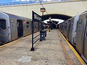
This station has two tracks and an island platform. It is partially under the New York Connecting Railroad (NYCR) viaduct, which also carries the tracks of Amtrak's Northeast Corridor. Most of the platform is north of the viaduct.
History
Opening

This station opened on February 1, 1917, along with the rest of the Astoria Line, which was originally part of the
On July 23, 1917, the Queensboro Bridge spur of the elevated IRT Second Avenue Line opened. At that time, all elevated trains to Queensboro Plaza used the Astoria Line while all subway trains used the Corona Line, though this was later changed with trains alternating between branches.[4][7] This station started to be served by BMT shuttles using elevated cars on April 8, 1923.[8]
The city government took over the BMT's operations on June 1, 1940,
Renovations
In 1981, the MTA listed the station among the 69 most deteriorated stations in the subway system.
In February 2018, the MTA announced that the station would be renovated for 14 months beginning in April of that year, as part of a $22 million project. The station house, mezzanine, and stairs would be repaired. Some residents protested, arguing that the renovated station would lack elevators, and that then-ongoing full closures of the
Station layout
| Platform level | Southbound | ← ← |
| Island platform | ||
| Southbound | ← ← | |
| Mezzanine | Fare control, station agent, MetroCard machines | |
| Ground | Street level | Exit/entrance |

The Astoria–Ditmars Boulevard station has two tracks and an
The 2018 artwork at this station is Urban Idyll by painter
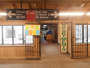
Exits
The station's only mezzanine is a station house beneath the tracks and platforms. Two double-wide staircases from the platform go down to their own bank of turnstiles with a token booth in the middle. Outside
Provisions for proposed extensions

There was a proposed, but never-built, extension of the line toward Bayside and possibly LaGuardia Airport.[21] In 1998, an extension of the BMT Astoria Line to LaGuardia Airport was planned as part of a $1.2 billion package to provide access to the New York City airports with funding from the MTA, the Port Authority and the city. The preferred route would have extended the Astoria Line along 31st Street north onto Con Edison’s property at the edge of Astoria and then east along 19th Avenue to the Marine Air Terminal. The MTA also considered an eastward extension along Ditmars Boulevard, and a plan to reroute LaGuardia-bound trains from Queensboro Plaza through the Sunnyside rail yard and along the eastern edge of St. Michael’s Cemetery to elevated tracks parallel to the Grand Central Parkway. A fourth route was to have trains turn east via Astoria Boulevard.[22] All of the options would have new elevated sections built. $645 million for the LaGuardia extension was included in the MTA’s 2000-2004 Five-Year Capital Plan, and in late 2002, Mayor Bloomberg supported the extension. These options were studied in the LaGuardia Airport Subway Access Study.[23] Community opposition was strong and therefore the plan was canceled in July 2003.[24][25] After the AirTrain LaGuardia people mover, which would have run to Mets–Willets Point, was canceled in 2023, a panel of three transportation experts recommended that the Port Authority of New York and New Jersey operate a shuttle bus route from the airport to the Astoria–Ditmars Boulevard station.[26][27]
The Regional Plan Association, in its Fourth Plan in 2017, anticipated that the population of Astoria would quickly grow over the next three decades, and so called for the Astoria Line to be extended to a new storage yard at Ditmars Boulevard and 20th Street, which would provide added capacity. In addition, a new station at 21st Avenue and 20th Street would improve access for the currently underserved but dense northwest parts of Astoria.[28]
Ridership
In 2019, the station had 5,277,341 boardings, making it the 120th most used station in the 423-station system. This amounted to an average of 17,912 passengers per weekday.[2]
Image gallery
-
 Platform before 2019 renovation
 -
 Elisabeth Condon's Urban Idyll piece in the station's mezzanine.
 -
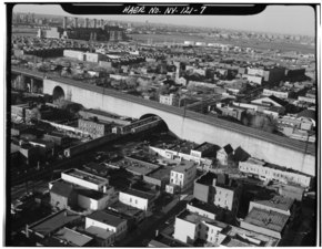 Station seen in 1970's
 -
 Gerry Building Entrance


References
- ^ "Glossary". Second Avenue Subway Supplemental Draft Environmental Impact Statement (SDEIS) (PDF). Vol. 1. Metropolitan Transportation Authority. March 4, 2003. pp. 1–2. Archived from the original (PDF) on February 26, 2021. Retrieved January 1, 2021.
- ^ a b "Annual Subway Ridership (2017–2022)". Metropolitan Transportation Authority. 2022. Retrieved November 8, 2023.
- Newspapers.com.
- ^ a b Annual report. 1916-1917. New York: Interborough Rapid Transit Company. 1917. Archived from the original on September 29, 2018. Retrieved August 7, 2018.
- ^ Brooklyn Daily Eagle. February 1, 1917. Archived from the original on April 7, 2018. Retrieved June 29, 2015 – via Newspapers.com.

- ^ "Street Name Changes in Queens, New York". One-Step Webpages by Stephen P. Morse. Archived from the original on August 29, 2015. Retrieved June 29, 2015.
- ^ "Subway Link Over Queensboro Bridge". The New York Times. July 22, 1917. p. 31. Archived from the original on August 21, 2019. Retrieved December 18, 2011.
- ^ "Additional Subway Service to Borough of Queens". The New York Times. April 8, 1923. p. RE1. Archived from the original on August 21, 2019. Retrieved December 18, 2011.
- from the original on July 19, 2021. Retrieved May 14, 2022.
- ProQuest 1243059209.
- from the original on January 7, 2022. Retrieved May 14, 2022.
- ProQuest 1248134780.
- ^ "Direct Subway Runs to Flushing, Astoria". The New York Times. October 15, 1949. p. 17. Archived from the original on August 21, 2019. Retrieved December 18, 2011.
- ^ Gargan, Edward A. (June 11, 1981). "Agency Lists its 69 Most Deteriorated Subway Stations". The New York Times. Archived from the original on March 31, 2019. Retrieved August 13, 2016.
- ^ from the original on September 7, 2023. Retrieved May 5, 2023.
- from the original on April 28, 2022. Retrieved May 5, 2023.
- ^ Barone, Vincent (February 8, 2018). "Queens residents, politicians are fed up with MTA construction". am New York. Archived from the original on February 11, 2018. Retrieved February 10, 2018.
- OCLC 49777633 – via Google Books.
- ^ "Astoria Ditmars Blvd". MTA Arts & Design. MTA. 2018. Archived from the original on August 30, 2019. Retrieved November 15, 2019.
- ^ "MTA Neighborhood Maps: Astoria" (PDF). Metropolitan Transportation Authority. 2015. Archived (PDF) from the original on November 23, 2018. Retrieved September 27, 2015.
- ^ Martin, Douglas (November 17, 1996). "Subway Planners' Lofty Ambitions Are Buried as Dead-End Curiosities". The New York Times. Archived from the original on August 7, 2017. Retrieved June 27, 2015.
- ^ Kabak, Benjamin (January 19, 2010). "Dreams of taking the N to LaGuardia". Second Ave. Sagas. Archived from the original on April 29, 2016. Retrieved May 1, 2016.
- ^ "Second Avenue Subway Supplemental Draft Environmental Impact Statement (SDEIS), April 2003 Appendix A Planning Context" (PDF). mta.info. Metropolitan Transportation Authority. April 2003. Archived (PDF) from the original on August 18, 2016. Retrieved August 9, 2016.
- ^ Toscano, John (July 16, 2003). "N Train Extension To LaG Scrapped". Queens Gazette. Archived from the original on May 25, 2009. Retrieved July 26, 2009.
- ^ "Flashback To 1999". www.qgazette.com. June 27, 2007. Archived from the original on March 22, 2016. Retrieved March 25, 2014.
- from the original on March 14, 2023. Retrieved March 13, 2023.
- ^ "LaGuardia AirTrain NYC: Hochul scraps plan and MTA, Port Authority improve bus service". ABC7 New York. March 13, 2023. Archived from the original on March 13, 2023. Retrieved March 14, 2023.
- ^ "Fourth Regional Plan - Regional Plan Association". Regional Plan Association. November 2017. Archived from the original on February 13, 2023. Retrieved January 22, 2022.
External links
- nycsubway.org – BMT Astoria Line: Ditmars Boulevard
- Station Reporter — N Train
- TheSubwayNut - Astoria-Ditmars Boulevard
- Ditmars Boulevard entrance from Google Maps Street View
- Platform from Google Maps Street View
| Astoria Line | |
|---|---|
| |