
Atatürk Dam
| Atatürk Dam | ||
|---|---|---|
Annual generation | 8,900 gigawatt-hours (32,000 TJ) | |
The Atatürk Dam (
The dam is situated 23 km (14 mi) northwest of Bozova, Şanlıurfa Province, on state road D-875 from Bozova to Adıyaman. Centerpiece of the 22 dams on the Euphrates and the Tigris, which comprise the integrated, multi-sector, Southeastern Anatolia Project (Turkish: Güney Doğu Anadolu Projesi, known as GAP), it is one of the world's largest dams. The Atatürk Dam, one of the five operational dams on the Euphrates as of 2008, was preceded by Keban and Karakaya dams upstream and followed by Birecik and the Karkamış dams downstream. Two more dams on the river have been under construction.
The dam embankment is 169 m high (554 ft) and 1,820 m long (5,970 ft). The hydroelectric power plant (HEPP) has a total installed power capacity of 2,400
The dam was depicted on the reverse of the Turkish one-million-lira banknotes of 1995–2005[4] and of the 1 new lira banknote of 2005–2009.[5]
Dam
The initial development project for the southeastern region of Turkey was presented in 1970. As the objectives for regional development have changed significantly and the ambitions have grown in the 1970s, the original plan underwent major modifications. The most important change in the project was abandoning the Middle Karababa Dam design, and adopting the design of the Atatürk Dam to increase the storage and power generation capacities of the dam.[6]

Dolsar Engineering and ATA Construction, two prominent Turkish companies, signed for the building of the dam.[7] The construction of the cofferdam began in 1985 and was completed in 1987. The fill work for the main dam lasted from 1987 to 1990.[1] The Atatürk Dam, listed in international construction publications as the world's largest construction site, was completed in a world record time of around 50 months.[3]
The rock-fill dam undergoes deformations that are regularly and systematically monitored since 1990 with different types of sensors. It is estimated that the central portion of the dam crest has settled by around 7 m (23 ft) since the end of the construction. Settlement of the dam crest up to 4.3 m (14 ft) has been measured since the start of the detailed geodetic monitoring in 1992. The maximum horizontal (radial) deformation measured is about 2.9 m (9.5 ft).[1]
The
Hydroelectric power plant
The HEPP of the Atatürk Dam is the biggest of a series of 19 power plants of the GAP project. It consists of eight
During the periods of low demand for electricity, only one of the eight units of the HEPP is in operation while in times of high demand, all the eight units are in operation. Hence, depending upon the energy demand and the state of the interconnected system, the amount of water to be released from the HEPP might vary between 200 and 2,000 m3/s in one day.[12]
Irrigation

Originating in the mountains of eastern Anatolia and flowing southwards to Syria and Iraq, the Euphrates and the Tigris are very irregular rivers, used to cause great problems each year with droughts in summer and flooding in winter. The water of the Euphrates River is regulated by means of large reservoirs of the Keban and Atatürk Dams. However, the waters released from the HEPPs of those dams also need to be regulated. The Birecik and the Karkamış Dams downstream the Atatürk Dam are constructed for the purpose of harnessing the waters released from large-scale dams and HEPPs.
Nearly 4,760 km2 (1,840 sq mi) of arable land in the
The Atatürk Dam and the Şanlıurfa Tunnel system are two major components of the GAP project. Irrigation started in the Harran Plain in the spring of 1995. The impact of the irrigation on the economy of the region is significant. In ninety percent of the irrigated area, cotton is planted. Irrigation expansion within the Harran plains also increased Southeastern Anatolia's cotton production from 164,000 to 400,000 metric tons in 2001, or nearly sixty percent. With almost 50% share of the country's cotton production, the region developed to the leader in Turkey.[13]
Reservoir lake

The
Some 10 towns and 156 villages of three provinces are located around the Lake Atatürk Dam. The lake provides a fisheries and recreation site. For transportation purposes, several ferries have been operated in the reservoir.[16] The reservoir lake is called "sea" by local people.[17]
Geostrategic importance
About 90% of Euphrates' total annual flow originates in Turkey, while the remaining part is added in Syria, but nothing is contributed further downstream in Iraq. In general, the stream varies greatly in its flow from season to season and year to year. As an example, the annual flow at the border with Syria ranged from 15.3 km3 (3.7 cu mi) in 1961 to 42.7 km3 (10.2 cu mi) in 1963.
One of the most important legal texts on the waters of the Euphrates-Tigris river system is the protocol annexed to the 1946 Treaty of Friendship and Good Neighborly Relations between Iraq and Turkey. The protocol provided the control and management of the Euphrates and the Tigris depending to a large extent on the regulations of flow in Turkish source areas. Turkey agreed to begin monitoring the two border-crossing rivers and to share related data with Iraq. In 1980, Turkey and Iraq further specified the nature of the earlier protocol by forming a joint committee on technical issues, which Syria joined later in 1982 as well. Turkey unilaterally guaranteed to allow 15.75 km3/year (500 m3/s) of water across the border to Syria without any formal agreement on the sharing of the Euphrates water.[14]
Mid-January 1990, when the first phase of the dam was completed, Turkey held back the flow of the Euphrates entirely for a month to begin filling up the reservoir. Turkey had notified Syria and Iraq by November 1989 of her decision to fill the reservoir over a period of one month explaining the technical reasons and providing a detailed program for making up for the losses.[18] The downstream neighbors protested vehemently. At this point, the Atatürk Dam has cut the flow from the Euphrates by about a third.[19]
Syria and Iraq claim to be suffering severe
Two damaging earthquakes of M w 5.5 and M w 5.1 occurred in the town of Samsat near the Atatürk Reservoir in 2017 and 2018, respectively. The spatio-temporal evolution of seismicity and its source properties in relation to the temporal water-level variations and the stresses resulting from surface loading and pore-pressure diffusion shows the water-level and seismicity rate are anti-correlated in this dam,[21] which is explained by the stabilization effect of the gravitational induced stress imposed by water loading on the local faults. The overall effective stress in the seismogenic zone increased over decades due to pore-pressure diffusion, explaining the enhanced background seismicity during recent years.[21]
See also
- Nissibi Euphrates Bridge
-
 Landsat4 image of pre-Atatürk Dam, Harran (August 20, 1983)
 -
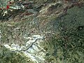
 Landsat7 image of the Atatürk Dam (March 27, 2000)
 -
 Landsat7 image of post-Atatürk Dam, Harran (August 24, 2002)


References
- ^ a b c d S. Malla; M. Wieland; R. Straubhaar (2006-10-17). "Monitoring Atatürk Dam". International Water Power & Dam Construction. Archived from the original on 2007-10-25. Retrieved 2008-02-02.
- ^ "Atatürk Dam". State Hydraulic Works. 2008. Archived from the original on 2014-07-02. Retrieved 2008-02-02.
- ^ a b "ATA Group". Archived from the original on 19 December 2007. Retrieved 2008-02-02.
- ^ Central Bank of the Republic of Turkey Archived 2009-06-15 at the Wayback Machine. Banknote Museum: 7. Emission Group - One Million Turkish Lira - I. Series Archived 2012-02-29 at the Wayback Machine, II. Series Archived 2012-02-29 at the Wayback Machine & III. Series Archived 2012-02-29 at the Wayback Machine. – Retrieved on 20 April 2009.
- ^ Central Bank of the Republic of Turkey Archived 2009-06-15 at the Wayback Machine. Banknote Museum: 8. Emission Group - One New Turkish Lira - I. Series Archived 2012-02-29 at the Wayback Machine.
Announcement on the Withdrawal of E8 New Turkish Lira Banknotes from Circulation Archived April 22, 2009, at the Wayback Machine, 8 May 2007. – Retrieved on 20 April 2009. - .
- ^ a b "Hydroelectric Power Plants in Southern Turkey". Archived from the original on 2008-01-11. Retrieved 2008-02-02.
- ^ "Solétanche Bachy".
- ^ "Structurae International Database and Gallery of Structures". Retrieved 2008-02-02.
- ^ Chapin Metz, Helen, ed. (1995). "Turkey: A Country Study". Washington: GPO for the Library of Congress. Retrieved 2008-02-02.
- ^ a b "Tourism net". Retrieved 2008-02-02.
- ^ a b c "The Tigris & Euphrates Basin". Vital Facts:Water Resources and Middle East. Archived from the original on 2011-07-23. Retrieved 2008-02-02.
- ^ a b "Southeastern Anatolia Becomes a Major Cotton Producing Region for Turkey". U.S. Dept of Agriculture - Foreign Agricultural Service. 2001-08-28. Archived from the original on 2007-08-13. Retrieved 2008-02-03.
- ^ a b "Turkey". AQUASTAT - Food and Agriculture Organization of the United Nations. Archived from the original on 27 February 2008. Retrieved 2008-02-02.
- ^ "Turkey - GAP's Irrigation Component". U.S. Dept of Agriculture - Foreign Agricultural Service. Archived from the original on 2008-10-13. Retrieved 2008-02-03.
- ^ Duman, Erdal; Ahmet Çelik (2001). "Fishes Caught in Bozova Region of Atatürk Dam Lake and Their Production" (PDF). E.U. Journal of Fisheries & Aquatic Sciences. 18 (1–2). Ege University Press: 65–69. Archived from the original (PDF) on 2008-10-03. Retrieved 2008-02-04.
- ^ "Adıyamanlı". Archived from the original on 26 January 2008. Retrieved 2008-02-03.
- ^ Kibaroğlu, Ayşegül. "An Institutional Framework for Facilitating Cooperation in the Euphrates-Tigris River Basin" (PDF). Department of International Relations, Middle East Technical University, Ankara, Turkey. Archived from the original (PDF) on 2007-08-24. Retrieved 2008-02-08.
- ^ "Water May Be Next Flashpoint In Mideast". Senate. 1992-03-26. Retrieved 2008-02-02.[dead link]
- ^ De Châtel, Francesca (2003-01-14). "Turkish Water Project: Curse or Blessing?". Islam Online. Retrieved 2008-02-03.
- ^ ISSN 2296-6463.
External links
Crossings of the Euphrates | ||||
|---|---|---|---|---|
| ||||