
Atrato River
| Atrato River | |
|---|---|
 | |
| Location | |
| Country | Colombia |
| Physical characteristics | |
| Source | |
| • location | Colombia |
| Mouth | |
• location | Caribbean Sea, Colombia |
• coordinates | 8°10′45.2″N 76°56′28.7″W / 8.179222°N 76.941306°W |
| Length | 750 km (470 mi) |
| Basin size | 37,810 km2 (14,600 sq mi)[1] 35,996.7 km2 (13,898.4 sq mi)[2] |
| Discharge | |
| • location | Atrato Delta, Gulf of Urabá, Colombia |
| • average | 3,993 m3/s (141,000 cu ft/s)[3] 3,767.992 m3/s (133,065.4 cu ft/s)[4] |
| Basin features | |
| Tributaries | |
| • left | Truando |
| • right | Murrí, Sucio |
.svg)
The Atrato River (
In 2016, the Constitutional Court of Colombia granted the river legal rights of personhood after years of degradation of the river basin from large-scale mining and illegal logging practices, which severely impacted the traditional ways of life for Afro-Colombians and Indigenous people.
Watershed
The river’s total length is about 650 km (400 mi), and it is navigable as far as Quibdó (400 km / 250 mi), the capital of the department. The basin occupies an area of 37,810 km2 (14,600 sq mi) and has an average annual precipitation of >5,000 mm/year that reaches up to 12,000 mm/year in the upper basin.
Flowing through a narrow valley between the Cordillera and coastal range, it has only short tributaries, the principal ones being the Truandó, the Sucio, and the Murrí rivers.
The
Wildlife
Northwestern Colombia encompasses an area of great diversity in wildlife. During the Pleistocene era at the height of the Atrato river, where it intersected the Cauca-Magdalena, the area was covered by a sea. It is proposed that this created a geographic barrier that may have caused many species to diverge through the process of allopatric speciation.[6] For example, Philip Hershkovitz proposed that the cotton-top tamarin (Saguinus oedipus) and the white-footed tamarin (Saguinus leocopus) diverged because of the rise of the Atrato, and today they are principally separated by the river.[6]
Fish
- Andinoacara biseriatus - A Cichlid.[7]
History
In the 19th and early 20th centuries, the
In November 2016, the Constitutional Court of Colombia declared the legal personhood of the Atrato River possessing the rights to ‘’protection, conservation, maintenance, and restoration[11].'' While the Colombian Constitution does not explicitly recognize Rights of Nature [RoN], [12] ruled that it is a set of ‘’biocultural rights’’ that can be inferred from guarantees in the constitution for biodiversity, cultural, and humanitarian protections.[13] The ‘biocultural rights’’ claim emphasized that the cultural rights of Colombian Indigenous and Afro-Colombian citizens, and the biological rights of the Atrato River are inextricably linked. As a result, Judge Palacio ruled that the biocultural rights should support the conservation, restoration, and sustainable development of the Atrato River[14]
The ruling transpired from the degradation of the river basin from large-scale mining and illegal logging practices, which severely impacted the traditional ways of life for Afro-Colombians and Indigenous people.[13] Illegal logging changed the flow of the river, and illicit mining increased the level of toxic chemicals [i.e., mercury and cyanide] entering the river system, causing a threat to the biodiversity of the area, and adversely impacting the health of the vulnerable people of these societies, including children[14]
The court referred to New Zealand’s Te Awa Tupua Act (Whanganui River Claims Settlement)[15] and cited New Zealand’s recognition of the Whanganui River’s legal personhood as precedent.[13] Following that example, the court ordered the creation of a guardian body – the Commission of the Guardians of Atrato River, to represent the interests of the river, and manage the river’s resources in a sustainable way that is consistent with the river’s legal personhood status.[11] Initially, the commission would include government representatives and one community representative. However, civil society rejected the idea of just one community and instead made a request for fourteen council members to serve on the council.[11] The request was approved, and the council was formed in May 2018.[11]
-
 The Atrato River
 -
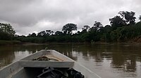 View from a side branch, in the Medio Atrato region
 -
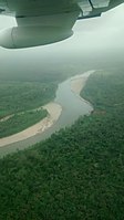 The river seen from above, Medio Atrato region.


References
- ^ Félix Dario, Sánchez; Martha, García; Omar, Jaramillo; Nelsy, Verdugo (2010). "ESTUDIO NACIONAL DEL AGUA 2010 (IDEAM) - Agua Superficial - Caracterización y análísis de la oferta" (PDF).
- ^ "Rivers Network". 2020.
- ^ Félix Dario, Sánchez; Martha, García; Omar, Jaramillo; Nelsy, Verdugo (2010). "ESTUDIO NACIONAL DEL AGUA 2010 (IDEAM) - Agua Superficial - Caracterización y análísis de la oferta" (PDF).
- ^ "Rivers Network". 2020.
- ^ a b c One or more of the preceding sentences incorporates text from a publication now in the public domain: Chisholm, Hugh, ed. (1911). "Atrato". Encyclopædia Britannica. Vol. 2 (11th ed.). Cambridge University Press. p. 876.
- ^ a b Hershkovitz, P (1977). Living New World Monkeys (Platyrrhini): with an introduction to Primates.
- ^ Froese, Rainer; Pauly, Daniel (eds.) (2017). "Andinoacara biseriatus" in FishBase. May 2017 version.
- ISBN 9781907945083.
- ^ "Interoceanic river aqueduct connecting the Pacific and Atlantic Oceans: [Colombia] (map)". Library of Congress. c. 1855. Retrieved 6 April 2020.
- ^ Isthmian Canal Commission (1901). Report of the Isthmian Canal Commission, 1899–1901 (pdf) (Report). United States Government Printing Office. p. 71:
While it is not impossible that a practicable line on which to construct a canal can be found with its terminus in the Atrato Valley, the necessary length of the line, together with the difficulties which would attend a terminus at the mouth of a large silt-bearing river, are enough to show that in use it would be inferior to either the Panama or the Nicaragua location.
- ^ S2CID 240805757, retrieved 2022-02-17
- ^ "Expert Profile Judge Jorge Iván Palacio". UN Harmony With Nature. Retrieved 2023-09-24.
- ^ OCLC 1231810967.)
{{cite book}}: CS1 maint: multiple names: authors list (link - ^ ISSN 0952-8873.
- ^ NZ Government (30 November 2022). "Te Awa Tupua (Whanganui River Claims Settlement) Act 2017".
| International | |
|---|---|
| National | |