
Atsinanana
Atsinanana Region | |
|---|---|
Region | |
UTC3 (EAT) | |
| HDI (2018) | 0.541[4] low · 5th of 22 |
Atsinanana is a coastal region in eastern Madagascar. It borders Analanjirofo region in the north, Alaotra-Mangoro in the west, Vakinankaratra and Amoron'i Mania in the southwest, and Vatovavy in the south. The region contains over 285km of coastline, which includes many beaches and cultural heritage sites.[5]
Atsinanana is known for its fish breeding and fishing near its ports, ore claims and mining activity, as well as its agriculture.[5]
The capital of the region is Toamasina, and the population was 1,484,403 in 2018. The area of Atsinanana is 21,934 km2 (8,469 sq mi), almost exactly the same as its neighbor, Analanjirofo.[3]
The current governor of Atsinanana is Richard Théodore Rafidison.
Administrative divisions
Atsinanana Region is divided into seven districts, which are sub-divided into 82 communes.
- Antanambao Manampotsy District- 5 communes
- Mahanoro District- 11 communes
- Marolambo District- 12 communes
- Toamasina I District - 1 commune
- Toamasina II District- 15 communes
- Vatomandry District- 15 communes
- Vohibinany District - 17 communes; a.k.a. Brickaville; a.k.a. Ampasimanolotra
Transport
Main highway is the road to the countries capital
.Airports
There is only one international airport:
Railroads
There is only one railroad line that leads to the capitol Antananarivo via Brickaville by Madarail but passenger services are only available up to Moramanga.
Protected areas
- Sahafina New Protected Area
- Part of Ankeniheny-Zahamena Corridor
- Nosivolo River
- Analalava Special Reserve
- Betampona Reserve
- Part of Zahamena National Park
- Mangerivola Reserve
- Part of Marolambo National Park
Bodies of Water
- The Canal des Pangalanes
- the Ambalona River
- Mania River
- Ivondro River
- Nosivolo River (a tributary of the Mangoro)
- Rianila river
- Mangoro River (at Mahanoro)
Gallery
-
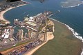 the Port of Toamasina
 -
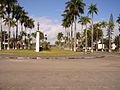 Toamasina, also called Tamatave
 -

-
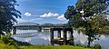
 Rianila River Bridge
 -

-
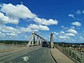
 Ivondro River bridge
 -
 beach at Vatomandry
 -
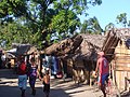 Foulpointe


References
- ^ "EDBM". Archived from the original on 2022-02-06. Retrieved 2021-05-09.
- ^ Ralison, Eliane; Goossens, Frans. "Madagascar: Profil des marchés pour les évaluations d'urgence de la sécurité alimentaire" (PDF) (in French). Programme Alimentaire Mondial, Service de l’Evaluation des besoins d’urgence (ODAN). Archived from the original (PDF) on 2007-09-26. Retrieved 2008-03-01.
- ^ a b "Troisieme Recensement General de la Population et de L'Habitation (RGPH-3) Resultats Provisoires" (PDF). Institut National de la Statistique Madagascar. Archived from the original (PDF) on June 24, 2021. Retrieved May 23, 2020.
- ^ "Sub-national HDI - Area Database - Global Data Lab". hdi.globaldatalab.org. Retrieved 2018-09-13.
- ^ a b "La Région Atsinanana à Madagascar". www.regions-francophones.org (in French). Retrieved 2021-10-17.
18°40′01″S 48°54′40″E / 18.66694°S 48.91111°E
This Atsinanana location article is a stub. You can help Wikipedia by expanding it. |