
Attapeu province
Attapeu province
ແຂວງ ອັດຕະປື | |
|---|---|
UTC+7 (ICT) | |
| ISO 3166 code | LA-AT |
| HDI (2017) | 0.559[2] medium · 12th |
Attapeu (Lao: ອັດຕະປື [ʔát.tā.pɯ̀ː]) is a province of Laos in the southeast of the country. It has five districts: Samakkixay, Xaysetha, Sanamxay, Sanxay, and Phouvong, covering an area of 10,320 square kilometres (3,980 sq mi) with a population of 127,285.[3] Its capital city lies at Attapeu (Muang Samakkixay).
It was known as the "land of heroism". There are two biodiversity areas: Dong Ampham Forest (200,000 ha) and Xepaine Forest.[4] A large part of the province is managed by the Dong Ampham National Biodiversity Conservation Area.
History
The province was part of the
Geography
Attapeu province covers an area of 10,320 square kilometres (3,980 sq mi).[5][4] It borders Sekong province to the north, Vietnam (Kom Tum) to the east, Virachey National Park of Cambodia (Ratanakiri and Stung Treng) to the south, and Champasak province to the west. Notable settlements in the province include Attapeu, Ban Nonghin, Ban Xoutouat, Ban Nong Songhong, Ban Renthuk, Ban Phiahom, Ban Choim, Ban Pakha, Ban Onglouang, Ban Het, Muang May, Ban kong Han, Ban Xakhe, and Ban Dakkrong.[6]
The province's terrain is rugged.[citation needed] Its capital city Attapeu (Samakkhixay District) is in a valley. The Bolaven Plateau stretches across Attapeu as well as three others provinces, Champasak, Salavan, and Sekong.[citation needed] The landscape of the province consists of thick forest, rivers and streams and plains areas in the backdrop of mountains such as Phou Saphong and Phou Luang.[4] The principal rivers are the
Protected areas

The 71,400 hectare Attapu Plain is an Important Bird Area (IBA) adjacent to the NBCA. It is at an elevation of 200–400 metres (660–1,310 ft). The topography includes wetlands, such as the Xe Khaman and the Xe Xou Rivers, as well as freshwater lakes and pools. Dry forest landscapes, dry deciduous forest, shingle and stony beaches are habitats. Notable avifauna are the lesser fish eagle Ichthyophaga humilis, red-headed vulture Sarcogyps calvus, and white-rumped vulture Gyps bengalensis.[12]
Administrative divisions
The province is composed of the following districts:[4]
| Map | Code | Name | Vietnamese | Lao script |
|---|---|---|---|---|

| ||||
| 17-01 | Saysetha District
|
Mueang Xaysetha | ເມືອງໄຊສະຖານ | |
| 17-02 | Samakkhixay District
|
Mueang Samakkhixay | ເມືອງສະໝັກຄີໄຊ | |
| 17-03 | Sanamxay District
|
Mueang Sanamxay | ເມືອງສະໜາມໄຊ | |
| 17-04 | Sanxay District
|
Mueang Sanxay | ເມືອງສານໄຊ | |
| 17-05 | Phouvong District
|
Mueang Phouvong | ເມືອງພູວົງ |
Demographics
Lao Loum people in Attapeu outnumber those in other nearby provinces.[citation needed] Its population is reported to be 110,000 and consists of several ethnic communities; 15 major tribes are reported in the province which include Lao, Alak, Katang, Kaleum, Katou, Suay, Oy, Taoy, Sadang, Nge, Lavea, Lavenh, Cheuang, Tariang and Nyaheung groups.[4]
Economy


Attapeu's economy is largely agricultural. In this province, the trade in wild life is significant (though underestimated by the government) and hence its conservation is important. The listed globally threatened wild life species number 14 (according to the
Given its proximity to Vietnam, the province has traditionally been a source for raw materials and forest products for adjacent regions in Vietnam. Luxury forest products exported by Champa through its seaports were sourced from places as far as Attapeu.[14]
More recently, some Vietnamese companies expanded into Attapeu province. Hoang Anh Gia Lai Group has acquired rights to grow rubber trees in the province. The company also plans to invest in electricity generation, sugar refining, and organic fertilizer production.[15] Construction of a US$100 million sugar project including industrial facilities started in November 2011.[16]
Landmarks
Some of the important locations in the province are the
Villages
Gallery
-
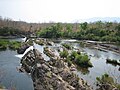 Xekong province: Tad Feak Falls, just across the border from Attapeu
 -
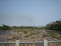 Forested area, Attapeu province
 -
 Attapeu village


References
- ^ Brinkhoff, Thomas (11 September 2020). "Statistical data from the yearly provincial census of Laos. 2020 official". city population. Open publishing. Retrieved 22 February 2022.
- ^ "Sub-national HDI - Area Database - Global Data Lab". hdi.globaldatalab.org. Retrieved 13 September 2018.
- ^ "Attapeu Overview". Tourism Laos. Tourism Marketing Department, Ministry of Information, Culture and Tourism. Archived from the original on 4 November 2016. Retrieved 4 September 2018.
- ^ a b c d e f g h i "Destination: Attapeu Province". Lao Tourism Organisation. Archived from the original on 13 October 2013. Retrieved 30 November 2012.
- ^ "Home". Regions. Official website of Laos Tourism. Archived from the original on 11 January 2013. Retrieved 7 January 2013.
- ^ "Base Map:Lao People's Democratic Republic (LPDR)". UNOSAT. Archived from the original on 25 March 2013. Retrieved 4 December 2012.
- ^ The Lao National Tourism Administration. "Attapeu Province". Ecotourism Laos. GMS Sustainable Tourism Development Project in Lao PDR. Archived from the original on 29 August 2012. Retrieved 1 December 2012.
- ^ "Dong Ampham National Biodiversity Conservation Area". Protectedplanet.net. Retrieved 21 July 2012.
- ^ Islam 2010, p. 257.
- ^ Claridge 1996, p. 32.
- ^ Bush, Elliot & Ray 2010, p. 307.
- ^ "Important Bird Areas factsheet: Attapu Plain". BirdLife International. 2012. Archived from the original on 14 October 2015. Retrieved 9 December 2012.
- ^ "Trade in Natural Resources in Attopu Province". Mekong Wetlands Biodiversity Conservation and Sustainable Use Programme. Archived from the original on 29 September 2013. Retrieved 30 November 2012.
- ^ Hardy, Cucarzi & Zolese 2009, p. 114.
- ^ Nguyen, Binh (17 March 2011). "HAGL diversifies investment portfolio in Laos". Saigon Times. Archived from the original on 6 October 2011. Retrieved 1 July 2011.
- ^ "Vietnam group starts huge sugar project in Laos". Vietnam Investment Review. 23 November 2011. Archived from the original on 15 April 2012. Retrieved 7 December 2011.
- ^ Bush, Elliot & Ray 2010, p. 308.
- ^ Bush, Elliot & Ray 2010, p. 310.
Bibliography
- Bush, Austin; Elliot, Mark; Ray, Nick (1 December 2010). Laos 7. Lonely Planet. pp. 307–. ISBN 978-1-74179-153-2.
- Claridge, Gordon (1996). An Inventory of Wetlands of the Lao P.D.R. IUCN. pp. 32–. ISBN 978-2-8317-0319-0.
- Hardy, Andrew David; Cucarzi, Mauro; Zolese, Patrizia (2009). Champa and the Archaeology of Mỹ Sơn (Vietnam). NUS Press. ISBN 978-9971-69-451-7.
- Islam, Nahid (1 January 2010). Law of Non Navigational USes Intl Watercourses: Option Regional. Kluwer Law International. pp. 257–. ISBN 978-90-411-3196-6.
Places adjacent to Attapeu province | |
|---|---|