
Attavyros (municipality)
Attavyros
Αττάβυρος | |
|---|---|
UTC+3 (EEST ) |

Attavyros (
municipality on the island of Rhodes, in the Dodecanese, Greece. Since the 2011 local government reform it is part of the municipality Rhodes, of which it is a municipal unit.[2]
Geography
The population is 2,127 (2021 census); the land area is 234.350 km².Emponas. Its largest other towns are Ágios Isídoros and Kritinia. In land area it is the second-largest municipal unit on Rhodes and the second-least densely populated, after South Rhodes (Notia Rodos).
The municipal unit is composed by five communities:
| Community | Population (2011) | Localities (main locality shown in italics) |
|---|---|---|
| Agios Isidoros (Άγιος Ισίδωρος) |
355
|
Agios Isidoros (355 inh.) |
Emponas (Έμπωνας) |
1,242
|
Emponas (1,061 inh.) Mandriko (Μανδρικό, 181 inh.) |
| Kritinia (Κρητηνία) |
503
|
Kritinia (454 inh.) Kameiros Skala (Κάμειρος Σκάλα, 49 inh.)
|
| Monolithos (Μονόλιθος) |
181
|
Monolithos (181 inh.) |
| Siana (Σιάνα) |
152
|
Siana (151 inh.) Lakki (Λακκί, 1 inh.) |
Gallery
-
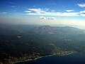 Aerial view of Attavyros mountain and municipal unit
 -
 Attavyros mountain
 -
 Temple of Zeus at the top of Attavyros Mountain


References
- ^ "Αποτελέσματα Απογραφής Πληθυσμού - Κατοικιών 2021, Μόνιμος Πληθυσμός κατά οικισμό" [Results of the 2021 Population - Housing Census, Permanent population by settlement] (in Greek). Hellenic Statistical Authority. 29 March 2024.
- ^ "ΦΕΚ B 1292/2010, Kallikratis reform municipalities" (in Greek). Government Gazette.
- ^ "Population & housing census 2001 (incl. area and average elevation)" (PDF) (in Greek). National Statistical Service of Greece. Archived from the original (PDF) on 2015-09-21.