
Auckland Islands
Motu Maha or Maungahuka ( Ewing Island, Dundas Island, Green Island | |
|---|---|
| Area | 570[1] km2 (220 sq mi) |
| Highest elevation | 705 m (2313 ft) |
| Highest point | Mount Dick |
| Administration | |
| Area Outside Territorial Authority | New Zealand Subantarctic Islands |
| Demographics | |
| Population | 0 (2015) |

The Auckland Islands (
The islands are listed with the
Ecologically, the Auckland Islands form part of the Antipodes Subantarctic Islands tundra ecoregion. Along with other New Zealand Subantarctic Islands, they were designated a UNESCO World Heritage Site in 1998.[3]
Geography
The Auckland Islands lie 360 km (220 mi) south of Stewart Island, and 465 km (289 mi) from the South Island port of Bluff, between the latitudes 50° 30' and 50° 55' S and longitudes 165° 50' and 166° 20' E.
They include
Auckland Island, the main island, has an approximate land area of 510 km2 (197 sq mi), and a length of 42 km (26 mi). It is notable for its steep cliffs and rugged terrain, which rises to over 600 m (1,969 ft). Prominent peaks include Cavern Peak (659 m or 2,162 ft), Mount Raynal (635 m or 2,083 ft), Mount D'Urville (630 m or 2,067 ft), Mount Easton (610 m or 2,001 ft), and the Tower of Babel (550 m or 1,804 ft). The southern end of the island broadens to a width of 26 km (16 mi).[4]
Here, the narrow channel of Carnley Harbour (the Adams Straits on some maps) separates the main island from the roughly triangular Adams Island (97 km2 (37 sq mi)),[5] which is even more mountainous, reaching a height of 705 m (2,313 ft) at Mount Dick. The channel is the remains of the crater of an extinct volcano, and Adams Island and the southern part of the main island form the crater rim. The main island features many sharply incised inlets, notably Port Ross at the northern end.
The group includes numerous other smaller islands, notably Disappointment Island (northwest of the main island) and Enderby Island (off the northern tip of the main island), altogether covering 12 km2 (4.6 sq mi).[5]
Most of the islands have a volcanic origin, with the archipelago dominated by two 12-million-year-old Miocene shield volcanoes, subsequently eroded and dissected.[6][7] These rest on older volcanic rocks 15–25 million years old with some older granites and fossil-bearing sedimentary rocks from around 100 million years ago.[8]
Islands
The following table includes named islands according to Land Information New Zealand.[5]
| Location | Area (ha) |
|---|---|
| Auckland Island | 45,916.6 |
| Adams Island | 9,695.8 |
| Enderby Island | 695.9 |
| Disappointment Island | 289.5 |
| Rose Island | 80.2 |
| Ewing Island | 58.3 |
| Ocean Island | 11.9 |
| Detached Rock | 7.5 |
| Adams Rocks | 7.5 |
| Masked Island | 5.7 |
| Figure of Eight Island | 5.3 |
| Column Rocks | 5.2 |
| Dundas Island | 4.9 |
| Sugar Loaf Rocks | 4.8 |
| Monumental Island | 4.3 |
| Lantern Rocks | 3.9 |
| Green Island | 3.0 |
| Compadre Rock | 2.8 |
| Frenchs Island | 1.9 |
| Five Sisters Rocks | 1.9 |
| Yule Island | 1.6 |
| Friday Island | 1.6 |
| Pinnacle Rocks | 1.5 |
| Pillar Rock | 1.2 |
| Blanche Rock | 1.0 |
| Amherst Rock | 0.8 |
| Shag Rock | 0.5 |
| Beehive Rock | 0.4 |
| Beacon Rock | 0.3 |
| Davis Island | 0.1 |
| Archer Rock | 0.1 |
Total |
56,816.1 |
Climate
Port Ross features a subpolar oceanic climate (Cfc according to the Köppen climate classification system). Like many other Subpolar oceanic climates, Port Ross, along with the Auckland Islands in general, are characterised by the near-constant overcast weather and never being too hot or too cold.
This borders on an extremely mild-wintered, maritime-influenced tundra climate.
| Climate data for Port Ross (1941–1945) | |||||||||||||
|---|---|---|---|---|---|---|---|---|---|---|---|---|---|
| Month | Jan | Feb | Mar | Apr | May | Jun | Jul | Aug | Sep | Oct | Nov | Dec | Year |
| Record high °C (°F) | 18.3 (65.0) |
19.3 (66.8) |
18.5 (65.3) |
14.3 (57.7) |
12.3 (54.2) |
10.8 (51.4) |
12.4 (54.4) |
12.1 (53.7) |
14.1 (57.4) |
15.8 (60.5) |
15.6 (60.0) |
17.3 (63.2) |
19.3 (66.8) |
| Mean daily maximum °C (°F) | 14.8 (58.6) |
14.4 (58.0) |
12.9 (55.2) |
10.7 (51.3) |
9.1 (48.4) |
7.8 (46.1) |
8.8 (47.8) |
8.8 (47.8) |
9.9 (49.9) |
11.3 (52.3) |
12.1 (53.7) |
13.4 (56.1) |
11.2 (52.1) |
| Daily mean °C (°F) | 11.2 (52.1) |
11.0 (51.8) |
9.8 (49.7) |
8.8 (47.8) |
6.5 (43.7) |
5.4 (41.7) |
6.1 (42.9) |
5.8 (42.5) |
6.9 (44.4) |
7.8 (46.1) |
8.4 (47.2) |
9.8 (49.7) |
8.1 (46.6) |
| Mean daily minimum °C (°F) | 7.6 (45.7) |
7.5 (45.5) |
6.8 (44.2) |
6.4 (43.5) |
4.1 (39.3) |
3.2 (37.8) |
3.3 (37.9) |
2.9 (37.2) |
3.8 (38.9) |
4.4 (39.9) |
5.0 (41.0) |
6.3 (43.3) |
5.1 (41.2) |
| Record low °C (°F) | 2.1 (35.8) |
2.4 (36.3) |
1.4 (34.5) |
0.8 (33.4) |
−1.6 (29.1) |
−1.8 (28.7) |
−2.6 (27.4) |
−1.7 (28.9) |
−1.8 (28.7) |
−1.6 (29.1) |
−0.3 (31.5) |
0.2 (32.4) |
−2.6 (27.4) |
| Average precipitation mm (inches) | 110 (4.2) |
120 (4.8) |
140 (5.5) |
180 (7.0) |
150 (5.9) |
150 (5.8) |
84 (3.3) |
110 (4.3) |
120 (4.9) |
100 (4.1) |
110 (4.4) |
120 (4.9) |
1,494 (59.1) |
| Average precipitation days | 22 | 22 | 27 | 27 | 26 | 26 | 28 | 28 | 27 | 27 | 25 | 26 | 311 |
| Source: https://newzealandecology.org/system/files/articles/ProNZES12_37.pdf | |||||||||||||
| Climate data for Port Ross (1941–1945) | |||||||||||||
|---|---|---|---|---|---|---|---|---|---|---|---|---|---|
| Month | Jan | Feb | Mar | Apr | May | Jun | Jul | Aug | Sep | Oct | Nov | Dec | Year |
| Average sea temperature °C (°F) | 10.4 (50.8) |
10.5 (51.0) |
10.2 (50.5) |
9.6 (49.3) |
8.5 (47.4) |
7.8 (46.1) |
7.6 (45.7) |
7.2 (45.1) |
7.7 (46.0) |
8.2 (46.8) |
8.8 (47.9) |
9.5 (49.2) |
8.8 (47.9) |
| Climate data for Carnley Harbour (1941–1945) | |||||||||||||
|---|---|---|---|---|---|---|---|---|---|---|---|---|---|
| Month | Jan | Feb | Mar | Apr | May | Jun | Jul | Aug | Sep | Oct | Nov | Dec | Year |
| Record high °C (°F) | 16.7 (62.0) |
18.8 (65.8) |
18.1 (64.5) |
14.6 (58.3) |
11.2 (52.1) |
12.0 (53.6) |
13.1 (55.6) |
12.2 (54.0) |
14.0 (57.2) |
14.6 (58.2) |
14.7 (58.4) |
15.7 (60.2) |
18.8 (65.8) |
| Mean daily maximum °C (°F) | 12.9 (55.3) |
13.4 (56.2) |
12.9 (55.2) |
10.7 (51.2) |
8.4 (47.1) |
7.9 (46.3) |
8.6 (47.5) |
8.4 (47.1) |
9.2 (48.5) |
10.2 (50.4) |
10.6 (51.0) |
11.6 (52.8) |
10.4 (50.7) |
| Daily mean °C (°F) | 10.1 (50.2) |
10.4 (50.7) |
10.1 (50.2) |
8.1 (46.6) |
5.9 (42.6) |
5.7 (42.2) |
6.1 (42.9) |
5.6 (42.0) |
6.4 (43.6) |
6.8 (44.3) |
7.1 (44.7) |
8.2 (46.7) |
7.5 (45.6) |
| Mean daily minimum °C (°F) | 7.2 (45.0) |
7.3 (45.2) |
7.3 (45.2) |
5.6 (42.0) |
3.3 (38.0) |
3.4 (38.1) |
3.4 (38.2) |
2.8 (37.0) |
3.8 (38.9) |
4.1 (39.3) |
4.2 (39.5) |
5.1 (41.1) |
4.8 (40.6) |
| Record low °C (°F) | 3.3 (37.9) |
3.3 (37.9) |
2.9 (37.3) |
1.2 (34.1) |
−1.7 (29.0) |
−0.1 (31.9) |
−1.4 (29.5) |
−1.6 (29.1) |
−0.8 (30.5) |
0.3 (32.5) |
−0.4 (31.2) |
−0.2 (31.6) |
−1.7 (29.0) |
| Average precipitation mm (inches) | 180 (7.2) |
140 (5.7) |
140 (5.7) |
250 (9.8) |
240 (9.3) |
190 (7.4) |
130 (5.3) |
190 (7.3) |
150 (5.9) |
130 (5.1) |
140 (5.4) |
220 (8.6) |
2,100 (82.7) |
| Average precipitation days | 25 | 24 | 26 | 28 | 29 | 29 | 29 | 30 | 29 | 29 | 25 | 28 | 331 |
| Source: https://newzealandecology.org/system/files/articles/ProNZES12_37.pdf | |||||||||||||
Carnley Harbour also features a subpolar oceanic climate (Cfc according to the Köppen climate classification system), though it exaggerates the features shown in Port Ross, as it is much wetter and a lot more affected by ocean-moderation.
The Auckland Islands have a fairly constant cool and wet weather year-round, with neither winter being excessively cold nor summer excessively hot. The climate is most similar to that seen in the Faroe Islands and Aleutian Islands.
History
Discovery and early exploitation
Evidence exists that Polynesian voyagers first discovered the Auckland Islands. Traces of Polynesian settlement, possibly dating to the 13th century, have been found by archaeologists on Enderby Island.[9] This is the most southerly settlement by Polynesians yet known.[10]
The whaler Ocean discovered the islands in 1806, finding them uninhabited.[11] Captain
Whalers and sealers set up temporary bases, the islands becoming one of the principal sealing stations in the Pacific in the years immediately after their discovery.[11] By 1812, so many seals had been killed that the islands lost their commercial importance and sealers redirected their efforts towards Campbell and Macquarie Islands. Visits to the islands declined, although recovering seal populations allowed a modest revival in sealing in the mid-1820s.
The sealing era lasted from 1807 till 1894, during which time 82 vessels are recorded as visiting for sealing purposes. Some 11 of these ships were wrecked off-shore.[12] Relics of the sealing period include inscriptions, the remains of huts, and graves.
Settlement
Now
The Auckland Islands were part of the Colony of New Zealand under the Letters Patent of April 1842, which fixed the southern boundary of New Zealand at 53° south, but they were then excluded by the New Zealand Constitution Act 1846, which defined the southern boundary at 47° 10' south; however, they were again included by the New Zealand Boundaries Act of 1863, an act of the Imperial Parliament at Westminster that extended the boundaries of the colony once more.[14]
Shipwrecks

The Grafton, captained by Thomas Musgrave, was wrecked in Carnley Harbour in 1864. Madelene Ferguson Allen's narrative about her great-grandfather, Robert Holding, and the wreck of the Scottish sailing ship Invercauld, wrecked in the Auckland Islands a few months later in 1864, counterpoints the Grafton story.[15] François Édouard Raynal wrote Wrecked on a Reef.[16]
In 1866, one of New Zealand's most famous shipwrecks, that of the General Grant, occurred on the western coast. Ten survivors waited for rescue on Auckland Island for 18 months. Several attempts have failed to salvage its cargo, allegedly including bullion.[17]
Because of the probability of wrecks around the islands, calls arose for the establishment of emergency depots for castaways in 1868. The New Zealand authorities established and maintained three such depots, at Port Ross, Norman Inlet and Carnley Harbour from 1887. They also cached additional supplies, including boats (to help reach the depots) and 40 finger-posts (which had smaller amounts of supplies), around the islands.[18]
A further maritime tragedy occurred in 1907, with the loss of the Dundonald and 12 of her crew, off Disappointment Island. The 15 survivors lived off the supplies in the Auckland Island depot.[19]
In 2019, a helicopter with three passengers crashed into the ocean near Enderby Island, when they were en route to uplift an ill man on a fishing trawler.[20] The three passengers survived the crash, and were found the next day with only minor injuries.[21] The rescue effort was led by Richard Hayes.[22]
Scientific research and reserve
Three independent scientific expeditions arrived into the Auckland Islands in 1840.
The
From 1941 to 1945, the islands hosted a New Zealand
Currently[update] the islands have no inhabitants, although scientists visit regularly and the authorities allow limited tourism on Enderby Island and Auckland Island.[23]
The marine environment surrounding the archipelago became a marine mammal sanctuary in 1993 and, unusually, also a marine reserve in 2003, measuring 4,980 km2 (1,920 sq mi).[27] The Subantarctic Islands marine reserves around the Auckland, Antipodes, Bounty and Campbell Islands combined form the largest natural sanctuary in New Zealand.[28][29]
Ecology
Plants
The botany of the islands was first described in the
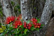
The vegetation of the islands sub-divides into distinct altitudinal zones. Inland from the salt-spray zone, the fringes of the islands predominantly feature forests of southern rātā
-
 Gentianella concinna, an endemic plant of the Auckland Islands.
 -


Invertebrates
The islands host the largest communities of subantarctic invertebrates, with 24 species of spider, 11 species of
Fresh and saltwater fauna
The freshwater environments of the islands host a freshwater fish, the kōaro or
is endemic to the islands.Marine mammals
There are two species of seal which
A well-recovering population in excess of 2,000 southern right whales is found off the islands, and Port Ross area is considered to be the most important and well-established congregating ground for whales in New Zealand waters. Its importance exceeds the Campbell Island ground.[38]
-
 Southern right whales cavorting in Port Ross
 -
 By the 21st century the islands had become the primary breeding location of New Zealand sea lions.


Birds
The islands hold important
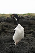
The whole Auckland Island group has been identified as an Important Bird Area (IBA) by BirdLife International because of its significance as a breeding site for several species of seabirds as well as eight endemic species or subspecies, including Auckland shag, Auckland teal, Auckland rail, Auckland snipe, Gibson's albatross, Auckland Island banded dotterel, Auckland Island tomtit, and the now extinct Auckland Island merganser.[40][39] The seabirds include southern rockhopper and yellow-eyed penguins; Antipodean, southern royal, light-mantled and white-capped albatrosses; and white-chinned petrel.[41][42]
-
-

-
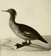 ExtinctNew Zealand merganser
 -
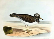 Locally extinct shore plover, once thought a separate species


Ecological history
Several
The New Zealand Department of Conservation plans to remove the last remaining introduced mammals from Auckland Island, making the entire island group pest-free, in what would be one of the largest multi-species eradication plans in the world.[47][48] This project started in November 2018, with NZ$2 million of initial scoping work. The total cost for the eradication could stretch to NZ$40–50 million over 10 years.[49]
List of endemic animals
- Auckland Island wētā (Dendroplectron aucklandensis)
- Auckland Islands cockle (Austrovenus aucklandica)
- Auckland rail (Lewinia muelleri)
- Auckland snipe (Coenocorypha aucklandica aucklandica)
- Auckland teal (Anas aucklandica)
- Auckland shag (Leucocarbo colensoi)
- Auckland Island merganser (Mergus australis) - extinct
- Auckland Island tomtit (Petroica macrocephala marrineri)
- Auckland Island banded dotterel (Charadrius bicinctus exilis)
- Gibson's albatross (Diomedea antipodensis gibsoni)
List of endemic plants
- Azorella schizeilema
- Callitriche aucklandica
- Cardamine depressa subsp. depressa
- Cardamine latior
- Dracophyllum cockayneanum
- Gentianella cerina
- Gentianella concinna
- Geum albiflorum
- Plantago aucklandica
- Poa aucklandica subsp. aucklandica
Legal status
The Auckland Islands – as with all of New Zealand's subantarctic islands – is a National Nature Reserve, afforded the highest possible level of protection under New Zealand law. In addition, a marine reserve encompasses all of the Auckland Islands territorial sea and internal waterways.[2]
All of New Zealand's subantarctic islands are managed by the Southland Conservancy of the Department of Conservation (DOC). Expedition party size, length of stay and landing on the islands are kept to a minimum. Entry is by permit only and applicants must undergo thorough pre-expedition quarantine checks.[2]
When
See also
- Composite Gazetteer of Antarctica
- Scientific Committee on Antarctic Research
- Territorial claims in Antarctica
- List of Antarctic and subantarctic islands
- List of islands of New Zealand
References
- ^ a b c "Auckland Islands". doc.govt.nz. Retrieved 7 February 2024.
- ^ a b c West, Carol (May 2005). "New Zealand Subantarctic Islands Research Strategy" (PDF). Department of Conservation. Retrieved 26 June 2019.
- ^ "New Zealand Sub-Antarctic Islands". UNESCO.
- Department of Conservation. Retrieved 17 October 2017.
- ^ a b c "NZ Primary Parcels". linz.govt.nz. Retrieved 7 February 2024.
- ^ ISBN 951-98947-0-5.
- . Retrieved 25 June 2022.
- .
- ^ "4. Early human settlement – Subantarctic islands". Te Ara Encyclopedia of New Zealand. 24 January 2013. Retrieved 2 August 2013.
- ^ Don Macnaughtan (11 February 2014). "Mystery Islands of Remote South Polynesia: Bibliography of Prehistoric Settlement on Norfolk Island, the Kermadecs, Lord Howe, and the Auckland Islands". Retrieved 30 May 2018.
- ^ a b McLaren, F.B. (1948). The Auckland Islands: Their Eventful History. Wellington: A.H and A.W Reed.
- ^ Headland, R.K. (ed.) (2018) Historical Antarctic Sealing Industry, Cambridge, Scott Polar Research Institute, p.166.
- ^ Conon Fraser, The Enderby settlement; Britain's whaling venture on the subantarctic Auckland Islands 1849–1852, Otago University Press, 2014.
- OCLC 154283103.
- ISBN 0-7735-1688-3.
- ^ Raynal, Francois Edouard (2003). "Wrecked on a Reef or Twenty Months among the Auckland Isles – A facsimile of the text and illustrations of the 1880 edition published by Thomas Nelson & Sons, London, Edinburgh, and New York, with additional commentaries by Christiane Mortelier". Steele Roberts, New Zealand. Retrieved 27 March 2010
- ISBN 9780478184518.
- ^ "Discover the heritage sites in the Auckland Islands". Retrieved 20 July 2019.
- ^ "The 'Dundonald' wrecked on the Auckland Islands in 1907". freepages.rootsweb.com.
- ^ "Auckland Islands helicopter pilot recalls violent crash". Stuff. 26 April 2019. Retrieved 27 April 2019.
- ISSN 1170-0777. Retrieved 27 April 2019.
- ^ "Auckland Islands helicopter trio found alive after wreckage found in Southern Ocean". Stuff. 23 April 2019. Retrieved 27 April 2019.
- ^ a b c d e f Miskelly, Colin M.; Taylor, Rowland H. (2020). "Ornithological discovery, exploration, and research on the Auckland Islands, New Zealand subantarctic". Notornis.
- ^ Godley, Eric John (1 May 1979). "The 1907 Expedition to the Auckland and Campbell Islands, and an unpublished report by B. C. Aston". Tuatara. 23 (3): 133–157.
- OCLC 1022254.
- Wikidata Q125494803.
- ^ "Data Table – Protected Areas – LINZ Data Service (recorded area 498000 ha)". Land Information New Zealand. Retrieved 27 August 2019.
- ^ "Subantarctic islands". doc.govt.nz. Retrieved 9 August 2019.
- ^ Fox, Michael (2 March 2014). "Birds, seals, penguins protected". Stuff news. Retrieved 9 August 2019.
- ^ Joseph Dalton Hooker (1844). Flora Antarctica, Volume 1, Parts 1–2, Flora Novae-Zelandiae – The Botany of the Antarctic Voyage of H.M. Discovery Ships Erebus and Terror in the years 1839–1843. London: Reeve Brothers. pp. title pages.
- .
- .
- ISBN 978-0-478-14470-3.
- ^ Campbell, D; Rudge, M (1976). "The case for controlling the distribution of the tree daisy Olearia lyallii Hook. F. in its type locality, Auckland Islands" (PDF). Proceedings of the New Zealand Ecological Society (23): 109–115.
- ISBN 0-7900-0719-3
- ^ "Elephant seal". www.doc.govt.nz.
- ^ "Leopard seal". www.doc.govt.nz.
- ^ Stewart R.; Todd B. (2001). "A note on observations of southern right whales at Campbell Island, New Zealand" (PDF). Journals of Cetacean Research Management. 2: 117–120. Retrieved 5 January 2015.
- ^ ISBN 978-0-9951136-6-4.
- ^ "Birds of the Auckland Islands - Colin Miskelly: Lost Gold". RNZ. 13 May 2020. Retrieved 23 December 2023.
- ^ "Important Bird Areas factsheet: Auckland Islands". BirdLife International. 2012. Retrieved 14 November 2014.
- ^ Miskelly, Colin M.; Elliott, Graeme; Parker, Graham Christopher; Rexer-Huber, Kalinka; Russ, Rodney; Taylor, Rowland H.; Tennyson, Alan; Walker, Kath (2020). "Birds of the Auckland Islands, New Zealand subantarctic". Notornis. 67 (1): 59–151.
- ^ "The Auckland Islands, South Pacific Ocean". Illustrated Sydney News. 16 October 1865.
- ^ Torr, N (2002). Eradication of rabbits and mice from subantarctic Enderby and Rose Islands (PDF). Archived from the original (PDF) on 12 July 2007.
- ^ Chimera, C.; Coleman, M. C.; Parkes, J. P. (1995). "Diet of feral goats and feral pigs on Auckland Island, New Zealand" (PDF). New Zealand Journal of Ecology. 19 (2): 203–207.
- ^ a b Russell, James; Horn, Stephen R.; Miskelly, Colin M.; Sagar, Rachael; Taylor, Rowland H. (2020). "Introduced land mammals and their impacts on the birds of the subantarctic Auckland Islands". Notornis. 67 (1): 247–268.
- ^ Nicoll, Dave (17 December 2017). "Department of Conservation Auckland Island eradication project may be largest in world". Stuff. Retrieved 7 December 2018.
- ^ Cox, Finlay; Frank, Veronika; Horn, Stephen; Hanley-Nickolls, Rose; Jacques, Paul; Sagar, Rachael; Ware, James (1 February 2021). "Maukahuka Pest Free Auckland Island – Technical feasibility study report" (PDF). Department of Conservation. p. 123.
- ^ Nicoll, Dave (16 November 2018). "DOC start field trials for Auckland Islands pest eradication project". Stuff. Retrieved 10 January 2019.
Further reading
- Wise's New Zealand Guide (4th ed.) (1969). Dunedin: H. Wise & Co. (N.Z.) Ltd.
- Appendix to the Journals of the House of Representatives of New Zealand (1863, Session III Oct–Dec) (A5)
- Island of the Lost: Shipwrecked At the Edge of the World (2007) by Joan Druett – an account of the Grafton and Invercauld wrecks
- Sub Antarctic New Zealand: A Rare Heritage by Neville Peat – the Department of Conservation guide to the islands
- Lost Gold : Ornithology of the subantarctic Auckland Islands. (2020) by Colin Miskelly. Wellington: Te Papa Press. OCLC 1141973732
External links
- Auckland Islands Marine Reserve (New Zealand Department of Conservation)
- High Resolution Map
- Murihiku.com
- A Map of the Islands
- Island Information
- Historical Timeline of the Auckland Islands (abandoned website, archived (abandoned website, archived by the Wayback Machine.
- Diary of a 1962–63 biological visit by E. J. Fisher
- 1948 article on Auckland Islands Coleoptera by E. S. Gourlay
- Islas Auckland – El archipiélago de los naufragios (in Spanish)
Culture:Anglosphere | |||||||||||||||
| |||||||||||||||
| |||||||||||||||
| |||||||||||||||
| |||||||||||||||
| |||||||||||||||
| |||||||||||||||
| |||||||||||||||
| International | |
|---|---|
| National | |