
Aumale
Aumale | |
|---|---|
 The town centre and church in Aumale | |
.svg) Coat of arms | |
Location of Aumale  | |
 Aumale  Aumale | |
| Coordinates: 49°46′17″N 1°45′11″E / 49.7714°N 1.7531°E | |
| Country | France |
| Region | Normandy |
| Department | Seine-Maritime |
| Arrondissement | Dieppe |
| Canton | Gournay-en-Bray |
| Intercommunality | CC Aumale - Blangy-sur-Bresle |
| Government | |
| • Mayor (2020–2026) | Virginie Lucot-Avril[1] |
| Area 1 | 9.06 km2 (3.50 sq mi) |
| Population (2021)[2] | 1,974 |
| • Density | 220/km2 (560/sq mi) |
| Time zone | UTC+01:00 (CET) |
| • Summer (DST) | UTC+02:00 (CEST) |
| INSEE/Postal code | 76035 /76390 |
| Elevation | 106–212 m (348–696 ft) (avg. 130 m or 430 ft) |
| 1 French Land Register data, which excludes lakes, ponds, glaciers > 1 km2 (0.386 sq mi or 247 acres) and river estuaries. | |
Aumale (French pronunciation: [omal]), formerly known as Albemarle,[3] is a commune in the Seine-Maritime department in the Normandy region in north-western France. It lies on the River Bresle.
History

The town's
Louis XIV purchased the title in 1675 in order to bestow it upon one of his bastards as an appanage. In 1769, it passed to the House of Orléans.[3] The English Earls of Albemarle, meanwhile, also derive their name from the area.[3]
During
SS operated a subcamp of the V SS construction brigade, in which over 500 men, mostly Poles and Soviets, worked as slave labour on the construction of facilities for the V-1 flying bombs.[4] The prisoners tried to resist the Germans, and several were murdered for sabotaging the rockets or escape attempts.[4] In August 1944, due to Allied advance, the Germans dissolved the subcamp and deported its prisoners to subcamps of the Mittelbau-Dora concentration camp.[4]
Geography
A village of
TER trains
.
Heraldry
 |
The arms of Aumale are blazoned : Argent, on a fess azure, 3 fleurs de lys Or.
|
Population
| Year | Pop. | ±% p.a. |
|---|---|---|
| 1968 | 2,833 | — |
| 1975 | 2,825 | −0.04% |
| 1982 | 2,876 | +0.26% |
| 1990 | 2,690 | −0.83% |
| 1999 | 2,577 | −0.48% |
| 2007 | 2,428 | −0.74% |
| 2012 | 2,279 | −1.26% |
| 2017 | 2,024 | −2.35% |
| Source: INSEE[5] | ||
Places of interest
- The church of Saints Peter and Paul, dating from the sixteenth century.
- The sixteenth-century Hôtel de ville (town hall).
- A seventeenth-century Hospital.
- The chapel of Our Lady of the Cardonnoy, dating from the thirteenth century.
- The seventeenth-century château du Bois Robin
- The tower and buildings of the 16th-century abbey.
Twin towns
Gallery
-
 Aumale church
 -
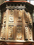 Sculpted wood panels on the pulpit
 -
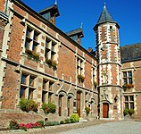 Town hall
 -
 The Bresle river by the Moulin du Roy
 -


See also
- Communes of the Seine-Maritime department
- Counts and Dukes of Aumale
References
- ^ "Répertoire national des élus: les maires". data.gouv.fr, Plateforme ouverte des données publiques françaises (in French). 2 December 2020.
- ^ "Populations légales 2021". The National Institute of Statistics and Economic Studies. 28 December 2023.
- ^ a b c "Baynes, T. S., ed. (1878). . Encyclopædia Britannica. Vol. 3 (9th ed.). New York: Charles Scribner's Sons. p. 85.
- ^ a b c "Aumale". aussenlager-buchenwald.de (in German). Retrieved 21 August 2022.
- ^ Population en historique depuis 1968, INSEE
External links
Wikimedia Commons has media related to Aumale (Seine-Maritime).
- Aumale official website (in French)
- . Encyclopædia Britannica. Vol. 2 (11th ed.). 1911. p. 921.
| International | |
|---|---|
| National | |
| Geographic | |
| Other | |