
Avenida 9 de Julio

July 9 Avenue (Spanish: Avenida 9 de Julio) is a major thoroughfare in the city centre of Buenos Aires, Argentina. Its name honors Argentina's Independence Day, July 9, 1816.
The avenue runs around 3 kilometres (1.9 mi) to the west of the
The northern end of the avenue is connected to the
History and overview
.JPG)
.JPG)
The idea of constructing July 9 Avenue (La Avenida 9 de Julio) was proposed during the time of Mayor Francisco Seeber (1889–1890). It was hoped to be like an artery that crossed through from the north to the south, connecting the two. Later it was included in diverse plans and projects, but it was not until 1912 that it passed the National Law 8.855[3] that authorized the municipality to carry it out. It was intended for public use within the blocks between the streets of Cerrito and Lima and Carlos Pellegrini to Bernardo de Irigoyen, from the Paseo de Julio (Avenida del Libertador) to Brazil (Barrio de Constitución) with the goal of constructing a 33-meter-wide central avenue, flanked with two wide streets and by public or private buildings of characterized style and special architecture built on the resulting land. The sale would be part of the financial funds along with the loan issued by the local government of 25 million gold pesos. This money would come directly from the income of the local government and with a 10% of direct contribution from the nation. If the central part corresponded well with the north–south axis, the project would complement the streets running from east to west and having two round-abouts: one located at the intersection of May Avenue (Avenida de Mayo) and the other at the intersection of Corrientes (Corrientes Avenue).[4][5]
As soon as the respective law was sanctioned, Mayor
The idea to construct the July 9 Avenue was maintained in the plan of 1925 where it was integrated into the North and South diagonals (proposed in 1919), forming at the ends two central monuments.

The avenue's unusual width is because it spans an entire city block, the distance between two streets in the checkerboard pattern used in Buenos Aires. The distance between adjacent streets is roughly 110 m, greater than the distance between streets in Manhattan.[citation needed] The street flanking 9 de Julio to the east is called Carlos Pellegrini (north of Rivadavia) and Bernardo de Irigoyen (south of Rivadavia). The street flanking 9 de Julio to the west is called Cerrito (north of Rivadavia) and Lima (south of Rivadavia).
The avenue was first planned in 1888, with the name of Ayohuma; but the road was long opposed by affected landlords and residents, so work did not start until 1935. The initial phase was inaugurated on October 12, 1937[7] and the main stretch of the avenue was completed in the 1960s. The southern connections were completed after 1980, when the downtown portion of the tollway system was completed. Clearing the right-of-way for these intersections required massive condemnations in the Constitución area.
Crossing the avenue at street level often requires a few minutes, as all intersections have traffic lights. Under normal walking speed, it takes pedestrians normally two to three green lights to cross it. Some urban planners have submitted projects to move the central part of the avenue underground to alleviate the perceived "chasm" between the two sides of the avenue.
MetroBus Line
9 de Julio line | |||||||||||||||||||||||||||||||||||||||||||||||||||||||||||||||||||||||||||||||||||||||||||||||||||||||||||||||||||||||||||||||||||||||||||||||||||
|---|---|---|---|---|---|---|---|---|---|---|---|---|---|---|---|---|---|---|---|---|---|---|---|---|---|---|---|---|---|---|---|---|---|---|---|---|---|---|---|---|---|---|---|---|---|---|---|---|---|---|---|---|---|---|---|---|---|---|---|---|---|---|---|---|---|---|---|---|---|---|---|---|---|---|---|---|---|---|---|---|---|---|---|---|---|---|---|---|---|---|---|---|---|---|---|---|---|---|---|---|---|---|---|---|---|---|---|---|---|---|---|---|---|---|---|---|---|---|---|---|---|---|---|---|---|---|---|---|---|---|---|---|---|---|---|---|---|---|---|---|---|---|---|---|---|---|---|
| |||||||||||||||||||||||||||||||||||||||||||||||||||||||||||||||||||||||||||||||||||||||||||||||||||||||||||||||||||||||||||||||||||||||||||||||||||

The Metrobus 9 de Julio is 3 kilometres (1.9 mi) long with 13 stations and runs down the avenue, taking roughly the same route as Line C of the Buenos Aires Underground. It serves 11 bus lines and reduces bus travel time by 50% along the avenue. The main objective of this line is to join the city's two busiest railway stations: Retiro and Constitución and to serve the approximately 250,000 passengers per day which use buses along the avenue, with a journey time of 15 minutes instead of the 30 minutes a bus took before the line was built.
Points of interest
The main landmarks along the avenue are, north to south:
- Palacio Ortiz Basualdo, headquarters of the French Embassy. The French government refused to submit the embassy building for demolition, and local preservationists opposed the move as well, as the building is widely hailed as an architectural masterpiece
- Teatro Colón
- The western end of Lavalle Street, a pedestrianized street formerly known for its many cinemas
- The Obelisk and Plaza de la República
- Statue of Don Quixote in the intersection with Avenida de Mayo
- The former Ministry of Public Works building (the only building sitting on the avenue itself, built immediately before the avenue), at the intersection with Moreno street, with large steel images of Eva Perón.
- Constitución stationand Plaza Constitución
34°36′28″S 58°22′53″W / 34.60778°S 58.38139°W
Gallery
-
 Panoramic view in the 1930s
 -
 Fountain at the intersection with Cordoba Avenue. Behind it, the former headquarters of FIAT Argentina
 -
 Avenida 9 de Julio at night
 -
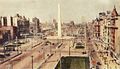
 Avenida 9 de Julio and the obelisk


References
- ^ "Inauguran hoy el Metrobús de la 9 de Julio". Infobae.
- ^ "Widest avenue". Guinness World Records. Retrieved October 12, 2022.
- ^ "CODIGO CIVIL Y COMERCIAL DE LA NACION". Información Legislativa. Archived from the original on February 23, 2019. Retrieved March 7, 2017.
- ^ a b de Hernani, Miguel (1962). Monumentos y paisajes de América Latina: Buenos Aires. México: Hermes.
- ISBN 9879792033.
- ISBN 9875070610.
- ^ "Caras y Caretas #2038 23/10/1937 pag 59". Biblioteca Nacional de España.