
Avenida Figueroa Alcorta

.jpg)
Avenida Figueroa Alcorta is a major thoroughfare in Buenos Aires, Argentina, with a length of over 7 km (4.3 mi) along the city's northside.
History
The rapid northward growth of the city of Buenos Aires during the late nineteenth century was facilitated by plans for a number of boulevards in the area by Mayor Torcuato de Alvear. Shortly after the opening of Viceroy Vértiz Avenue (today Avenida del Libertador) in 1906, a parallel boulevard was begun to serve the numerous upscale neighborhoods planned for the largely undeveloped northside.[1]
Planned with the assistance of
water reclamation
plant was subsequently built along the avenue's northern stretch.


stadium, finished in 1938.[4] The avenue was later graced by tennis and country clubs, parks and a number of monumental public buildings, though its boulevard medians were removed around 1970 to accommodate growing traffic. Excavations along the avenue in 2008 uncovered remains of the former Hansen's Café, among the city's first and most popular tango redoubts until its demolition in 1912.[5]
Itinerary

A one way thoroughfare, the avenue begins at its eastern end past the Buenos Aires
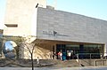
Eduardo Constantini opened his Latin American Art Museum of Buenos Aires (MALBA)
in 2001.
Passing by the
River Plate football stadium
.
Gallery
-
 The University of Buenos Aires Faculty of Law, Floralis Genérica in background.
 -
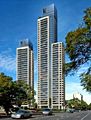 The Le Parc Figueroa Alcorta condominium towers.
 -
 The Japanese Gardens and architecture overlooking the avenue.
 -
-
 Cars on Avenida Figueroa Alcorta during noon.


References
- ^ palermonline.com Archived 2009-03-02 at the Wayback Machine (in Spanish)
- ^ todopropiedades.com (in Spanish) Archived August 28, 2008, at the Wayback Machine
- ^ "auto-historia.com" (in Spanish). Archived from the original on 2009-02-21. Retrieved 2009-02-21.
- ^ sitioriverplatense.com (in Spanish) Archived July 25, 2011, at the Wayback Machine
- ^ Clarín (in Spanish)
External links
Wikimedia Commons has media related to Avenida Figueroa Alcorta.