Northern end of Alem AvenueLocation of Avenida Leandro N. Alem in Buenos Aires.
Avenida Leandro N. Alem is one of the principal thoroughfares in Buenos Aires, Argentina, and a commercial nerve center of the city's San Nicolás and Retiro districts. It joins Avenida del Libertador and Avenida Paseo Colón, its northern and southern continuation respectively.
Overview
By way of a beautification effort, Viceroy
cottonwood trees (alamos, in Spanish), and was thus inaugurated in 1780 as the Paseo de la Alameda. The paseo became a popular weekend promenade, and its contiguous shores an unofficial riverfront park popular with bathers until an 1809 edict banned the practice for reasons of "moral terpitude."[1]
The frontage remained flood-prone, and in 1846, Governor
San Telmo, in subsequent works completed in 1865.[2]
The Paseo de Julio in 1867The Paseo de Julio at the turn of the 20th century
porticos, a regulation still in force and one which forced the paseo's more precarious establishments to close.[3]
A sudden economic and population boom led the new President of Argentina,
Argentine Congress in 1882 and financed by the prominent London-based Barings Bank (the chief underwriter of Argentine bonds and investment, at the time), the project required the reclaiming of over 200 hectares (500 acres) of underwater land and was accompanied by the widening of the Paseo de Julio into a boulevard.[4] These improvements were capped by the installation of a decorative fountain on the median, for which an Argentine student of Auguste Rodin's, Lola Mora, was commissioned. Unveiled in 1903, the Font of the Nereids sparked moralist outrage over its nude Venus, and the masterpiece was relocated to its present Puerto Madero site in 1918.[2]
The improved boulevard saw the replacement of clapboard structures for upscale office buildings, mostly influenced by
Leandro Alem, the founder of the centrist UCR, in a November 1919 ordinance. The UCR government completed the avenue's best-known landmark, the Buenos Aires Central Post Office
, in 1928, though a 1930 coup d'état resulted in the return of conservative rule.
Changes in national politics did not rename or adversely impact the avenue, which was further widened and improved by Mayor José Guerrico in 1931, adding new medians to delimit bus and taxi lanes, and giving the boulevard its approximate current layout. The avenue's eclectic
commercial real estate addresses, and its last undeveloped lots, municipal property totaling no more than 15,000 m2 (160,000 ft²) and estimated to be worth around US$80 million, were publicly proposed for sale in 2009.[5]


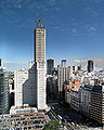 View of the avenue and the Alas Building
 Retiro Business District
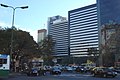
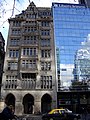 Bunge y Bornheadquarters


