
Bačka
This article has multiple issues. Please help improve it or discuss these issues on the talk page. (Learn how and when to remove these template messages)
|
Bačka
Bácska, Бачка | |
|---|---|
UTC+2 (CEST ) |
Bačka (
Name
According to Serbian historians, Bačka is a typical Slavic[1] name form, created from "Bač" (name of historical town in Bačka) and suffix "ka" (which designates "the land that belongs to Bač").
The name of "Bač" (Bács) town is of uncertain origin and its existence was recorded among Vlachs, Slavs and Hungarians in the Middle Ages. The origin of the name could be Paleo-Balkanic,[2] Romanian[citation needed], Slavic,[3] or Old Turkic.[4]
According to Hungarian historians, the denominator of the landscape may have been the first bailiff of Bač (Bács) castle, and the name which can be rendered probably Old Turkic baya derives from a dignity name.[5][6]
In the 17th and 18th century, due to the large number of
History
Through history, Bačka has been a part of

People have inhabited the region of Bačka since Neolithic times. Indo-European peoples settled in this region in three migration waves dated in 4200 BC, 3300 BC, and 2800 BC respectively. The earliest historical inhabitants of the region were probably Illyrian tribes. Later, other Indo-European peoples, including Dacians, Celts, Sarmatians (Iazyges) and Gepids were recorded as inhabitants of Bačka.
Middle Ages


At the turn of the first millennium, during the administration of the medieval
Early modern period
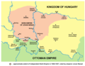
In 1526 the Kingdom of Hungary was defeated in the
After the Ottoman conquest, most of the previously decisive Hungarian majority population have fled (in the 16th–17th centuries). The relatively dense populated and prosperous southern counties of the Kingdom were devastated and became mostly abandoned and depopulated. During the Ottoman period, and later in the 17th and 18th century begun the intense settlement of the Serbs and other South Slavs from the Ottoman ruled central Balkans. They were military engaged in the borderlands by both sides. This resulted in radical changes of the population structure. Hungarian, Serb and Bunjevci peasants, and Serb and Vlach peasant soldiers lived (in ever-decreasing number) in the area, who had an impact on the landscape with their farming. In the Ottoman towns there was a Muslim population, and outside the city wall there were communities of various Christian denominations and occupations. Bačka was part of the Sanjak of Segedin (Szeged), the region was sparsely populated with Serbs (who were in an absolute majority[20]) and Muslims.

During the
In the Rákóczi's War of Independence heavy fightings took place also in Bačka. In 1704 Francis II Rákóczi led a victorious campaign in this parts. The Serbs fought on the Emperor's side since the beginning of the war. They were used as the light cavalry in the Austrian army and as tax collectors. During the eight years of war Hungarian villages and towns of the Great Hungarian Plain and Transdanubia were burnt and robbed by the Serbs, while in Bácska Serb villages were burnt. However, there were some Serbs who fought on Rakóczi's side against the Habsburgs – the Frontiersmen of Semlak. The leader of the Kuruc Serb troops was Frontier Captain Obrad Lalić from Senta. Later, some parts of the Military Frontier were abolished in 1751, these parts of Bačka were also included into Bács-Bodrog County. The only part of Bačka which remained within the Military Frontier was Šajkaška, but it also came under civil administration in 1873.
According to the Austrian censuses from 1715 to 1720,
There was also an emigration of Serbs from the eastern parts of the region, which belonged to Military Frontier until 1751. After the abolition of the Tisa-Mureş section of Military Frontier, many Serbs emigrated from north-eastern parts of Bačka. They moved either to Russia (notably to New Serbia and Slavo-Serbia) or to Banat, where the Military Frontier was still needed.[citation needed]
-
 Ancient Indo-European peoples in Bačka
 -
 Slavs in Bačka in the 6th century
 -
 Voivodeship (Duchy) of Bulgarian duke Salan, 9th century
 -
 Bach and Bodrogh counties in the 14th century
 -
 Serbian empire of Jovan Nenad, 1526–1527
 -
 Bačka as part of the Ottoman Sanjak of Segedin in 1568–1571
 -
 Military Frontier in Bačka in 1699


19th century
In 1848 and 1849, in the course of the
20th century
In early September 1914, several years before the end of the Austria-Hungary, in a town in the West Vojvodina Bačka region known as Zombor or Sombor of some 30,000 people, including 12,000 Serb-speakers, popular demonstrations demanded the removal of all shop signs in the Cyrillic alphabet. When an angry mob chased one Serb-speaking shopkeeper to his home for refusing to remove his Cyrillic sign, he responded by shooting at the demonstrators. The local military commander demanded the shopkeeper's immediate extradition, court martialed him and executed him on the spot. The court martial also designated twelve more affluent hostages from among the Serb-speaking population who would be "arrested and immediately executed by the military authorities" in the case of any obstruction or opposition shown by the local [Serb-speaking] population to the military authorities." This would presage the Serb genocide committed in the Independent State of Croatia during most of the Second World War.[29]
At the end of October 1918, Austria-Hungary gradually dissolved and, with the
On 1 December 1918, the Kingdom of Serbia united with the State of Slovenes, Croats and Serbs to form new country named the
Between 1820 and 1910, Hungarian speaking population in Bačka increased from 121,688 (31.5%) to 363,518 (44.75%). In the same time, percentage of South Slavs decreased from 44% in 1820 to 27% in 1910. 1921 census showed about 40,000 Hungarian speakers less than in census of 1910. This was especially case in Subotica where 1910 census recorded 55.587 speakers of Hungarian and 33,247 speakers of Bunjevac, while census of 1921 recorded 60,700 speakers of Serbo-Croatian and 26,750 speakers of Hungarian. This is explained by the fact that ethnic Bunjevci from Subotica who had knowledge of Hungarian language were listed as speakers of Hungarian by 1910 census. Between 1921 and 1931 census, number of Hungarian speakers in Bačka increased from 260,998 to 268,711. Slavic population increased by 91,800 inhabitants.[citation needed]
In 1941, Yugoslav Bačka was occupied by the
The occupation ended in 1944 and Yugoslav Bačka became part of the new
Together with eastern
-
 District of Potisje and Schajkasch Battalion, 18th-19th century
 -
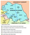 Bačka within the proclaimed borders of Serbian Voivodship in 1848
 -
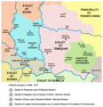
 Voivodeship of Serbia and Banat of Temeschwar (1849-1860)
 -
 Banat, Bačka and Syrmia after 1881, the five counties, which were formed in the territory of the former Voivodeship of Serbia and Banat of Temeschwar
 -
 Detailed map of Bács-Bodrog County
 -
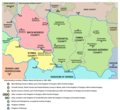
 Banat, Bačka and Baranja in 1918


.png)


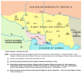
Geography
Bačka is a flat, fertile agricultural area within the larger
Most of the territory and a vast majority of the population of Bačka is part of Serbia's Autonomous Province of
Serbian Bačka


The
- West Bačka
- North Bačka
- South Bačka
Note that municipalities of Sremski Karlovci, Petrovaradin, and Beočin and southern part of municipality of Bačka Palanka that belong to South Bačka District are geographically not located in Bačka, but in Syrmia, while municipalities of Ada, Senta and Kanjiža which are geographically located in Bačka are part of North Banat District.
Geographic or traditional subregions or regions overlapping with Serbian Bačka include
Cities, towns and villages in the Serbian part of Bačka with more than 10,000 inhabitants (with population numbers from 2011 census):
- Novi Sad (250,439)
- Subotica (97,910)
- Sombor (47,623)
- Bačka Palanka (28,239)
- Vrbas(24,112)
- Bečej (23,895)
- Temerin (19,661)
- Senta (18,704)
- Futog (18,641)
- Kula(17,866)
- Veternik (17,454)
- Apatin (17,411)
- Bačka Topola (14,573)
- Srbobran (12,009)
- Kać (11,740)
Towns and villages in the Serbian part of Bačka with population between 5,000 and 10,000 inhabitants (with population numbers from 2011 census):
- Kanjiža (9,871)
- Ada (9,564)
- Žabalj (9,161)
- Crvenka (9,001)
- Odžaci (8,811)
- Čurug (8,166)
- Sivac (7,895)
- Palić (7,771)
- Bajmok (7,414)
- Čantavir (6,591)
- Rumenka (6,495)
- Bačko Petrovo Selo (6,350)
- Bački Petrovac (6,155)
- Mol(6,009)
- Horgoš (5,709)
- Bački Jarak (5,687)
- Kovilj (5,414)
- Bač (5,399)
- Titel (5,294)
- Bačko Gradište (5,110)
- Đurđevo (5,092)
- Kisač (5,091)
- Stara Moravica (5,051)
- Kljajićevo (5,045)
Note: Senta, Kanjiža, Ada, Mol and Horgoš are geographically located in Bačka, but they are part of the North Banat District.
Also see:
Hungarian Bácska
The Hungarian Bácska is mostly located in the
Subregions in the Hungarian Bácska include (with population numbers):
- Bajai(76,906)
- Bácsalmási (18,578)
- Jánoshalmai (17,885)
Note that parts of Hungarian Bácska also belong to the subregions of Kiskunhalasi and Mohácsi, although the main parts of those subregions are not located in Bácska.
Most important towns in Hungarian Bácska (with population numbers):
- Baja(38,143)
- Jánoshalma (9,866)
- Bácsalmás (7,694)
Demographics

Serbia
According to the 2022 Serbian census, the population of the Serbian part of Bačka (in geographical borders) numbers 924,879 people and is composed of:[35]
- 618,590 (66.88%) Serbs
- 141,688 (15.31%) Hungarians
- 756,013 (81.74%) Serbian language
- 136,730 (14.78%) Hungarian language
- others (including , etc.).
Hungary
According to the 2001 census in Hungary, the rough population of the Hungarian Bácska (including districts of Bajai, Bácsalmási, and Jánoshalmai) numbering 113,432 people. [2] Archived 27 September 2007 at the Wayback Machine Note that administrative borders of the districts do not fully correspond with the geographical borders of Hungarian Bácska. Most of the inhabitants of Hungarian Bácska are ethnic Hungarians. [3]
Gallery
-

-

-

-
-
 Wheat field near Temerin


![[3]](https://web.archive.org/web/20120113212859/http://lazarus.elte.hu/hun/maps/ke2500.gif)
See also
- Bačka Oblast
- Bács-Bodrog
- Bács-Kiskun
- Banat, Bačka and Baranja
- Eparchy of Bačka
- FK Bačka Bačka Palanka
- North Bačka District
- South Bačka District
- Vojvodina
- West Bačka District
Notes
- ^ Dr Dušan J. Popović, Srbi u Vojvodini, knjiga 1, Novi Sad, 1990, page 40.
- ^ Milica Grković, Rečnik imena Banjskog, Dečanskog i Prizrenskog vlastelinstva u XIV veku, Beograd, 1986
- ^ Dr. Aleksa Ivić, Istorija Srba u Vojvodini, Novi Sad, 1929
- ^ A Pallas Nagy Lexikona Archived 11 September 2006 at the Wayback Machine, pallaslexikon.hu; accessed 20 August 2016.(in Hungarian)
- ^ Lajos Kiss, Földrajzi nevek etimológiai szótára (Etimology Dictionary of Geographical Names), Akadémiai Kiadó, 1978, p. 71
- ^ Bálint Ila, József Kovacsics, Veszprém megye helytörténeti lexikona (Cyclopaedia of Local History of Veszprém county), Volume 2, Volume 2, Akadémiai Kiadó, 1988, p. 169
- ^ "U XVII i XVIII veku u Bačkoj je već toliko Srba da putnici ovaj kraj nazivaju »Raczorszag«"
- ^ "Google Translate".
- ^ Bojan Aleksov, Religious Dissent Between the Modern and the National: Nazarenes in Hungary and Serbia 1850–1914, Otto Harrassowitz Verlag, 2006, p. 56
- ^ "Archived copy". Archived from the original on 15 July 2011. Retrieved 15 March 2011.
{{cite web}}: CS1 maint: archived copy as title (link) - ^ "Archived copy". Archived from the original on 14 March 2012. Retrieved 15 March 2011.
{{cite web}}: CS1 maint: archived copy as title (link) - ^ "Archived copy". Archived from the original on 9 January 2011. Retrieved 15 March 2011.
{{cite web}}: CS1 maint: archived copy as title (link) - ^ "A Pallas nagy lexikona".
- ^ Stevan Pavlović (1870). Srbski narodni sabor u Sremskim Karlovcima godine 1869. U Platonovoj štampariji. p. 2.
- ^ Dr Milenko Palić, Srbi u Mađarskoj – Ugarskoj do 1918, Novi Sad, 1995, page 10.
- ISBN 978-963-8320-32-2.
- ^ ISBN 9789630112765.
- ^ "A szultán visszavonulása. | Borovszky Samu: Magyarország vármegyéi és városai | Kézikönyvtár".
- ^ Veselin P. Dželetović, Poslednji srpski car – Jovan Nenad, Beograd, 2007.
- ISBN 978-1-931313-75-9.
- ^ ""Istennel a hazáért és a szabadságért" - Újra belovagolt a Bácskába II. Rákóczi Ferenc | Délhír Portál". 27 October 2019.
- ^ a b "An International Symposium "Southeastern Europe 1918-1995"". Archived from the original on 11 April 2000. Retrieved 10 February 2011.
- ^ ISBN 978-1-931313-75-9.
- ^ "Etnikai konfliktusok és a magyar-szerb háború 1848-1849-ben".
- ^ "A "nagy szaladás"".
- ^ "A zentai véres gyertyaszentelő". 31 January 2017.
- ^ "Magyarország népessége".
- ^ "1910. ÉVI NÉPSZÁMLÁLÁS 1. A népesség főbb adatai községek és népesebb puszták, telepek szerint (1912) | Könyvtár | Hungaricana".
- ISBN 978-0-67404-776-1/LOC 2015036845.
- ^ Dr Drago Njegovan, Prisajedinjenje Vojvodine Srbiji, Muzej Vojvodine, Novi Sad, 2004.
- ^ Károly Kocsis, Eszter Kocsisné Hodosi, Ethnic Geography of the Hungarian Minorities in the Carpathian Basin, Simon Publications LLC, 1998, p. 116-153 [1][permanent dead link]
- ^ a b Dimitrije Boarov, Politička istorija Vojvodine, Novi Sad, 2001, page 183.
- ^ a b "[sim] Srbe podjednako ubijali okupator i i "oslobodioci"".
- ^ Nenad Stefanović, Jedan Svet na Dunavu, Beograd, 2003, page 133.
- ISBN 86-84433-07-6
Bibliography
- Fodor, Pál; Dávid, Géza, eds. (2000). Ottomans, Hungarians, and Habsburgs in Central Europe: The Military Confines in the Era of Ottoman Conquest. BRILL. ISBN 9004119078.
- ISBN 9781405142915.
External links
- BackaBanat.com
- Stanko Trifunović (1997). "Slovenska naselja V-VIII veka u Bačkoj i Banatu". Novi Sad: Muzej Vojvodine.
| West-Hungarian Borderland |  | |
|---|---|---|
| Little Hungarian Plain | ||
| Transdanubia | ||
| Transdanubian Mountains | ||
| Transdanubian Hills | ||
| North Hungarian Mountains | ||
| Great Hungarian Plain | ||
|  | |