
Bad Aibling Station
| Bad Aibling Station | |
|---|---|
| Part of the BND | |
| Located in Bad Aibling, Bavaria, Germany | |
 Radomes of Bad Aibling Station | |
 Bad Aibling Station  Bad Aibling Station | |
| Coordinates | 47°52′46″N 11°59′04″E / 47.879444°N 11.984444°E |
| Type | Signals and data gathering |
| Height | 492 m (1614 ft) |
| Site information | |
| Owner | BND |
| Open to the public | no |
| Condition | dismantled, relocated |
| Site history | |
| Built | 1936/1952 |
| In use | 1952–2004 |
| Demolished | 2004 |
The Bad Aibling Station (BAS), also known as the 18th United States Army Security Agency Field Station, Field station 81, and Hortensie III is a
Created by the Western Allies in 1947, it had been operated by the U.S. National Security Agency (NSA) until the early 2000s as operations have been transferred to the BND at Bad Aibling Station closure.[2]
As part of the global surveillance network
History
In 1936 a military airfield was established by the German National Socialist government at the site of a sport airfield in Bad Aibling-Mietraching.[3] After the Second World War, troops of the United States Army seized the military airport ("Fliegerhorst" and flight training base) that had evolved from the airfield. Initially, it was used by the occupying Americans as a camp for prisoners of war.[4] Günter Grass and Joseph Ratzinger, later Pope Benedict XVI, are claimed to have met there as prisoners.[5]
After the last prisoners had been discharged in 1946, the grounds of the airbase were transformed into a
In 1952, the area was taken over by the
In 1971 the
.In 1994, the NSA transferred command of its Bad Aibling base to INSCOM, one of the Central Security Services of the United States.[8]
After the end of the
Restructuring of the US intelligence community after September 11, 2001, caused the closure of Bad Aibling Station in September 2004. The base was transferred back to the
In the direct vicinity of Bad Aibling, a
Institutions (as known)
- TASCOM, APO 09108 / 09098 - Carl Mosher[11] 1972 & 1973
- 718th Military Intelligence Brigade
- 66th Military Intelligence Group, (relocated from Augsburg)
- USAF 402nd Intelligence Squadron
- Naval Security Group Activity
- 18th USASA Field Station, later 312th and 320th ASABattalion
Significance for secret services
The Bad Aibling Station was important in the ECHELON System (RSOC, Regional SIGINT Operation Center) employing appx 500 staff. Its supposed task was data interception for US and other allied intelligence services. The López affair that was cleared up by telephone surveillance in the BAS gained worldwide audience.
Officially its function has been "Rapid Radio Relay and Secure Common, Support to DoD and Unified Commands, Medium and Longhand Common HF & Satellite, Communication Physics Research, Test and Evaluate Common Equipment"[12]
Only few details are known. Serious hints, however, support the assumption that the BAS supervised numerous communication channels, including
-
 Field Station 81
 -

-
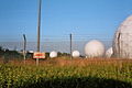 radome field
 -
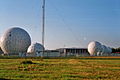 radome field
 -
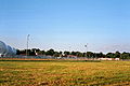 central area from south


References
- ^ Center for Cryptologic History: "Bad Aibling Station - A Legacy of Excellence"
- ^ David Ruppe. "U.S. to Close Eavesdropping Post". ABC News. Retrieved 21 December 2013.
- ^ History of the "Fliegerhorst" Mietraching at www.mietraching.de (in German)
- OCLC 163231900.
- ^ open book: Ratzinger and Grass
- OCLC 985977191.
- ^ OVB online: B&O-Gelände - einst und heute Archived 2015-09-17 at archive.today. Retrieved on September 16th, 2015
- ^ RAVEN: INSCOM in Bad Aibling (in German)
- ^ "Yorkshire CND: Bad Aibling Station to close". Archived from the original on 2002-08-12. Retrieved 2008-08-09.
- ^ Gude, Hubert; Poitras, Laura; Rosenbach, Marcel (August 5, 2013). "Mass Data: Transfers from Germany Aid US Surveillance". SPIEGELnet GmbH. SPIEGEL ONLINE 2013. Retrieved 2 June 2014.
- ^ "Carl Mosher". Archived from the original on 2012-03-16. Retrieved 2010-12-12.
- ^ Official report on the existence of a global system for the interception of private and commercial communications (ECHELON interception system) for the European Parliament
- ^ European Union and FBI launch global surveillance system. A Statewatch report. 27 February 1997
External links
- Message at military.com
- Information by US Army Security Agency Field Station Augsburg at the Wayback Machine (archive index)
- Video of a trip through the remainders of BAS in 2011 on YouTube—seven years after its closing and partly dismantling
47°52′46″N 11°59′04″E / 47.879444°N 11.984444°E
| Locations |
|  |
|---|---|---|
| Leaders | ||
| Divisions | ||
| Technology | ||
| Controversy |
| |
| Programs | ||
| Databases |
| |
| Other | ||