
Badlands National Park
| Badlands National Park | |
|---|---|
 Badlands National Park | |
 Location in South Dakota  Location in the United States | |
| Location | South Dakota, United States |
| Nearest city | Rapid City, South Dakota |
| Coordinates | 43°45′N 102°30′W / 43.750°N 102.500°W |
| Area | 242,756 acres (982.40 km2)[1] |
| Established | January 25, 1939 as a National Monument November 10, 1978 as a National Park |
| Visitors | 1,006,809 (in 2022)[2] |
| Governing body | National Park Service |
| Website | Badlands National Park |
 .jpg) |
| Southwestern South Dakota |
|---|
| Sculptures |
| Geologic and natural history |
| Mountains |
| Caves |
| Forests and wildernesses |
|
| Lakes |
| Scenic byways |
| Historic sites |
Badlands National Park (
Located within the
Authorized as Badlands National Monument on March 4, 1929, it was not established until January 25, 1939. Badlands was redesignated a national park on November 10, 1978.[10] Under the Mission 66 plan, the Ben Reifel Visitor Center was constructed for the monument in 1957–58. The park also administers the nearby Minuteman Missile National Historic Site. The movies Dances with Wolves (1990) and Thunderheart (1992) were partially filmed in Badlands National Park.[11]
This national park was originally a reservation of the Oglala Sioux Indians and spans the southern unit of the park. The area around Stronghold Table was originally Sioux territory, and is revered as a ceremonial sacred site rather than a place to live.
In 1868, at the Second Treaty of Fort Laramie, the United States assured the Sioux that the Badlands shall forever be the property of the Sioux. In 1889, however, the treaty was broken and the Badlands were confiscated by the United States.
At the end of the 19th century, the Sioux Indians used this area as the site of the Ghost Dance, a ceremony to revive the souls of buffalo and the dead. After the last ghost dance in 1890, the United States banned the ritual, but it was revived by the Red Power movement, a movement to restore Indian rights that began in the 1960s.[12][13] In 1980, the U.S. Supreme Court awarded compensation to the Sioux for the abrogation of the 1868 treaty, but the Sioux did not accept the money.[14][15]
History
Native Americans
This section needs additional citations for verification. (September 2019) |
For 11,000 years,
The next great change came toward the end of the 19th century as
Wounded Knee is located approximately 45 miles (72 km) south of the park on Pine Ridge Reservation. The U.S. government and the Oglala Lakota Nation have agreed that this is a story to be told by the Oglala of Pine Ridge and Minneconjou of Standing Rock Reservation. The interpretation of the site and its tragic events are held as the primary responsibility of these survivors.
Fossil record

The history of the White River Badlands as a significant
In 1846, Prout published a paper about the jaw in the
List of fossil animals

- Crocodilian)
- Entelodont)
- Nimravid)
- Oreodont)
- Nimravid)
- Nimravid)
- Creodont)
- Hyracodon (Running Rhino)
- Ground Squirrel-like Rodent)
- Tragulid)
- Oreodont)
- Mesohippus (Horse)
- Metamynodon (Aquatic Rhino)
- Oreodont)
- Poebrotherium (Camel)
- Subhyracodon (Rhinoceros)
Homesteading
Aspects of American
Military use of Stronghold District

.jpg)
As part of the World War II effort, the
Firing took place within most of the present-day Stronghold District. Land was bought or leased from individual landowners and the Tribe in order to clear the area of human occupation. Old car bodies and 55 gallon drums painted bright yellow were used as targets. Bulls-eyes 250 feet (76 m) across were plowed into the ground and used as targets by bombardiers. Small automatic aircraft called "target drones" and 60-by-8-foot (18 by 2 m) screens dragged behind planes served as mobile targets. Today, the ground is littered with discarded bullet cases and unexploded ordnance.
In the 1940s, 125 families were forcibly relocated from their farms and ranches, including Dewey Beard, a survivor of the Wounded Knee Massacre. Those that remained nearby recall times when they had to dive under tractors while out cutting hay to avoid bombs dropped by planes miles outside of the boundary. In the town of Interior, both a church and the building housing the current post office were struck by six inch (152 mm) shells through the roof. Pilots operating out of Ellsworth Air Force Base near Rapid City found it a real challenge to determine the exact boundaries of the range. There were no civilian casualties. However, at least a dozen flight crew personnel lost their lives in plane crashes.
The Stronghold District also known as the South Unit of Badlands National Park, consists of lands on the Pine Ridge Indian Reservation owned by the Oglala Sioux Tribe and managed by the
Legislative and administrative history
On March 4, 1929, his final day in office,
The Badlands National Monument was established in order to preserve the natural scenery and educational resources within its boundaries. The bill authorized specific scientific and educational institutions to excavate within the monument in the pursuit of educational,
Badlands National Park Superintendents[27]
- John E. Suter (1949–1953)
- John A. Rutter (1953–1957)
- George H. Sholly (1958–1959)
- Frank E. Sylvester (1960–1960)
- John W. Jay (1960–1962)
- Frank A. Hjort (1963–1967)
- John R. Earnst (1967–1970)
- Cecil D. Lewis, JR (1970–1974)
- James E. Jones (1974–1979)
- Gilbert E. Blinn (1979–1985)
- James L. Monheiser (1985–1985)
- Donald A. Falvey (1985–1987)
- Lloyd P. Kortge (1987–1987)
- Irvin L. Mortenson (1987–1996)
- Bill Supernaugh (1997–2004)[28]
- Paige Baker (2005–2010)[29]
- Eric Brunnemann (2010–2015)[30]
- Mike Pflaum (2015–2021)[31][32]
- Eric Veach (2022–Present)[33]
Wildlife
Animals that inhabit the park include:
- Wildlife in the park
-
 Prairie dogs
 -
 Bighorn sheep
 -
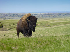 Bison bull


In 1963, 50 bison from Theodore Roosevelt National Park were released. The herd has grown to over 1,200 animals.[35] The bison habitat was expanded in 2019 by 22,000 acres (8,900 ha) to a total of 80,193 acres (32,453 ha) with the construction of 43 miles (69 km) of new fencing.[36] The Bighorn sheep population has increased over the last couple years to a total of 233.[37]
Endangered species
-
 Whooping Crane
 -
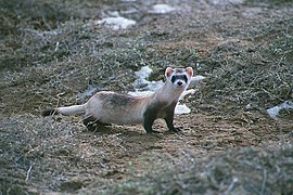 Black-footed ferret


The black-footed ferret and whooping crane are on the endangered species list.[38] The black-footed ferret population inside the Badlands National Park has recovered to a population of approximately 100 individuals.[39] This whooping crane population in the Badlands National Park is considered a non-self-sustaining wild population.[40]
Vegetation inventory
Twenty-three vegetation map classes and ten Anderson Level II land-use classes were used for interpretation of approximately 1.3 million acres encompassing the park (approximately 242,755 acres) and surrounding environs.[41]
A prairie is a large, open expanse of
Visitor services
Badlands National Park has two campgrounds for overnight visits – Cedar Pass and Sage Creek Campgrounds. Cedar Pass lodge offers accommodations in modern cabins and full-service dining.[50] The Ben Reifel Visitor Center within the park offers a bookstore, special programs, and museum exhibits. The White River Visitors center in the park's South Unit offers information about the region's Lakota heritage.
The Badlands Wilderness covers about one fourth of the park and was designated in 1976.
Climate
According to the
| Climate data for Interior, South Dakota (1991–2020 normals, extremes 1949–present) | |||||||||||||
|---|---|---|---|---|---|---|---|---|---|---|---|---|---|
| Month | Jan | Feb | Mar | Apr | May | Jun | Jul | Aug | Sep | Oct | Nov | Dec | Year |
| Record high °F (°C) | 71 (22) |
75 (24) |
85 (29) |
94 (34) |
102 (39) |
109 (43) |
114 (46) |
110 (43) |
106 (41) |
97 (36) |
84 (29) |
72 (22) |
114 (46) |
| Mean maximum °F (°C) | 58.2 (14.6) |
62.9 (17.2) |
75.4 (24.1) |
83.5 (28.6) |
90.6 (32.6) |
97.5 (36.4) |
102.6 (39.2) |
102.2 (39.0) |
99.1 (37.3) |
87.4 (30.8) |
71.7 (22.1) |
60.3 (15.7) |
104.4 (40.2) |
| Mean daily maximum °F (°C) | 37.1 (2.8) |
40.8 (4.9) |
52.5 (11.4) |
62.2 (16.8) |
72.1 (22.3) |
82.7 (28.2) |
91.2 (32.9) |
90.5 (32.5) |
81.8 (27.7) |
65.4 (18.6) |
50.0 (10.0) |
39.0 (3.9) |
63.8 (17.7) |
| Daily mean °F (°C) | 25.7 (−3.5) |
28.5 (−1.9) |
39.1 (3.9) |
48.4 (9.1) |
58.9 (14.9) |
69.2 (20.7) |
76.8 (24.9) |
75.3 (24.1) |
66.2 (19.0) |
51.6 (10.9) |
37.6 (3.1) |
27.8 (−2.3) |
50.4 (10.2) |
| Mean daily minimum °F (°C) | 14.2 (−9.9) |
16.2 (−8.8) |
25.8 (−3.4) |
34.7 (1.5) |
45.7 (7.6) |
55.7 (13.2) |
62.3 (16.8) |
60.2 (15.7) |
50.5 (10.3) |
37.8 (3.2) |
25.2 (−3.8) |
16.6 (−8.6) |
37.1 (2.8) |
| Mean minimum °F (°C) | −10.1 (−23.4) |
−6.4 (−21.3) |
3.8 (−15.7) |
18.8 (−7.3) |
31.0 (−0.6) |
43.5 (6.4) |
52.1 (11.2) |
48.1 (8.9) |
35.8 (2.1) |
19.6 (−6.9) |
6.0 (−14.4) |
−5.8 (−21.0) |
−16.5 (−26.9) |
| Record low °F (°C) | −28 (−33) |
−31 (−35) |
−23 (−31) |
3 (−16) |
20 (−7) |
32 (0) |
42 (6) |
35 (2) |
25 (−4) |
0 (−18) |
−21 (−29) |
−31 (−35) |
−31 (−35) |
| Average precipitation inches (mm) | 0.46 (12) |
0.55 (14) |
1.16 (29) |
2.26 (57) |
3.62 (92) |
3.46 (88) |
2.23 (57) |
1.81 (46) |
1.39 (35) |
1.59 (40) |
0.53 (13) |
0.54 (14) |
19.60 (498) |
| Average snowfall inches (cm) | 5.5 (14) |
6.4 (16) |
5.9 (15) |
6.4 (16) |
0.5 (1.3) |
0.0 (0.0) |
0.0 (0.0) |
0.0 (0.0) |
0.0 (0.0) |
1.9 (4.8) |
3.7 (9.4) |
7.7 (20) |
38.0 (97) |
| Average precipitation days (≥ 0.01 in) | 4.4 | 4.8 | 5.6 | 8.7 | 9.8 | 10.4 | 8.1 | 6.5 | 5.8 | 6.5 | 4.4 | 4.8 | 79.8 |
| Average snowy days (≥ 0.1 in) | 3.2 | 3.3 | 2.6 | 1.6 | 0.1 | 0.0 | 0.0 | 0.0 | 0.0 | 0.8 | 1.8 | 3.9 | 17.3 |
| Source: NOAA[52][53] | |||||||||||||
Gallery
-
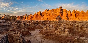
 Buttes and pinnacles
 -
 Boardwalk to the Windows
 -
 Door Trail
 -
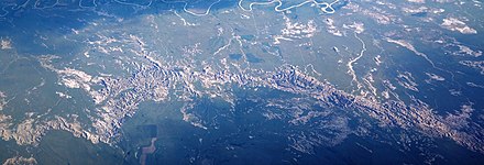 A southward aerial view of the park, with White River at the top (south) and the small town of Interior upper right center.


Current issues and challenges
Badlands National Park has been impacted by the rise of oil and gas pipelines and drilling, the debate over Native American land rights, fossil loss due to criminal activity, and climate change.
Oil pipelines/drilling
Badlands National Park faces growing encroachment from oil and gas companies hoping to transport
Land rights claims
The Badlands National Park also faces debate over the federal claims to the land once inhabited by the
Fossil depletion
The Badlands National Park was first established as a
Climate change
By 2050, the NPS predicts that Badlands National Park will have different conditions than are currently felt in the park—including increasing or decreasing temperatures, changes in quantity of total spring precipitation, potential delays in the start of spring within the park, and various increasing frequencies of heavy precipitation events.[56] Widespread summer drought is projected to be more likely in South Dakota within the same time frame (2050).[57] On average, the counties of Oglala Lakota, Pennington, and Jackson (the three main counties that the park occupies) have seen a gradual shift of monthly and annual temperatures between 1901 and 2021, leading to a warmer, drier environment.[56]
Current climate predictions developed by the NPS have allowed Badlands National Park to develop several management techniques preparing for different climate scenarios, categorized as "no-gainer", "no-regrets", or "no-brainer" management styles. According to the NPS Climate Scenarios brief for the park, a "no-gainer" is a current action that is not likely to achieve desired outcomes in any given future scenario. A "no-regrets" management style implements new actions that are likely to be successful in management of all potential future scenarios. "No-brainer" management involves maintaining current management practices that are likely to be beneficial, but aren't necessarily ideal. Climate Change management within the park primarily focuses on native vegetation, bison populations, species rehabilitation, archeological and paleontological preservation, and infrastructure and geohazards. Management plans for these values are primarily under the categories "no-regrets" and "no-brainer".[58]
See also
References
- ^ a b "Listing of acreage – December 31, 2011" (XLSX). Land Resource Division, National Park Service. Retrieved March 5, 2012. (National Park Service Acreage Reports)
- ^ "NPS Annual Recreation Visits Report". National Park Service. Retrieved July 26, 2023.
- LCCN 2008922508.
- ^ a b c "Badlands Visitor Guide: The official newspaper of Badlands National Park" (PDF). National Park Service. 2016. Retrieved July 25, 2016.
- ^ "Badlands Wilderness". Wilderness.net. Retrieved March 5, 2012.
- ^ "Badlands Visitor Guide" (PDF). National Park Service. 2008. p. 2. Retrieved March 12, 2011.
- ^ "Badlands National Park". Rand McNally. Archived from the original on February 25, 2011. Retrieved March 12, 2011.
The cultural centerpiece of this section is the Stronghold Table, where the Oglala Sioux danced the Ghost Dance for the last time in 1890.
- ^ "Pine Ridge Gunnery Range/Badlands Bombing Range". South Dakota Department of Environment & Natural Resources. Archived from the original on March 9, 2011. Retrieved March 12, 2011.
- ^ "U.S. National Park High Points". Peakbagger.com. Retrieved March 17, 2008.
- ^ "The National Parks: Index 2009–2011". National Park Service. Archived from the original on July 10, 2012. Retrieved March 5, 2012.
- ISBN 9781476625492.
- ^ "Wounded Knee Massacre & The Ghost Dance (article)". Khan Academy. Retrieved May 16, 2021.
- ^ "The Convenient Falsehoods We're Taught about Native American History". Edge Effects. September 5, 2017. Retrieved May 16, 2021.
- ^ Frommer, Frederic J. (August 19, 2001). "Black Hills Are Beyond Price to Sioux". Los Angeles Times. Retrieved December 12, 2021.
- ^ Streshinsky, Maria (February 9, 2011). "Saying No to $1 Billion". The Atlantic. Retrieved May 16, 2021.
- ^ "Article Series (U.S. National Park Service)". Nps.gov. Retrieved July 9, 2022.
- ^ "Badlands - Frequently Asked Questions". nps.gov. National Park Service. Retrieved March 1, 2018.
- ^ "Big Foot". U-s-history.com. Retrieved July 9, 2022.
- ^ Shaw, Ethan. "How Did Badlands National Park Get Its Name?". USA Today. Retrieved October 18, 2017.
- ^
 This article incorporates public domain material from Badlands National Park. National Park Service. Retrieved October 25, 2021.
- ISBN 9781625857644.
- ^ "Part 2:Listing of National Park System Areas by State". Archived from the original on July 10, 2012.
- ^ "Legislation for Park Establishment". National Park Service.
- ISBN 1135948593.
- ^ Annual Report of the Director of the National Park Service to the Secretary of the Interior. June 30, 1929. p. 38.
- ^ "Legislation for Park Establishment". National Park Service.
- ^ "National Park Service: Historic Listings of NPS Officials". Nps.gov.
- ^ Ray, Charles (August 18, 2003). "Trouble over the Badlands". Hcn.org. Retrieved April 30, 2020.
- ^ "Badlands National Park superintendent to retire". Rapidcityjournal.com.
- ^ Eilperin, Juliet (June 23, 2013). "In the Badlands, a tribe helps buffalo make a comeback". Washingtonpost.com.
- ^ "Mike Pflaum Selected as Superintendent of Badlands National Park - Badlands National Park (U.S. National Park Service)". Nps.gov.
- ^ "BADLANDS SUPERINTENDENT PFLAUM RETIREMENT". blackhillsbadlands.com.
- ^ "Eric Veach selected as superintendent of Badlands National Park - Regions 3, 4, and 5". National Park Service. Retrieved October 14, 2023.
- ^ Ruiz, Santi (September 13, 2020). "Bring Back the Bison". Yahoo News. Retrieved September 14, 2020.
- ^ "Bison, Buffalo, Tatanka: Bovids of the Badlands". U.S. National Park Service. Retrieved February 28, 2022.
- ^ Pittman, Travis (October 13, 2019). "Watch bison introduced to land they haven't touched in 150 years". CBS8. Retrieved August 30, 2022.
- ProQuest 2575842867.
- ^ "Map of threatened and endangered species in National Parks". Wildlife and Wild Lands. Retrieved April 18, 2022.
- hdl:1721.1/128984.
- ^ "ECOS: Species Profile". ecos.fws.gov. Retrieved April 18, 2022.
- ^ "Vegetation Inventory and Map for Badlands National Park (U.S. National Park Service)". Nps.gov. Retrieved July 9, 2022.
- ^ "Wildflower Search". Wildflowersearch.org. Retrieved July 9, 2022.
- ^ "Badlands Mixed-grass Prairies (U.S. National Park Service)". Nps.gov. Retrieved July 9, 2022.
- ^ "Natural Resource Condition Assessment : NRR 2018" (PDF). Npshistory.com. Retrieved July 16, 2022.
- ^ "10 Things You Didn't Know About Badlands National Park". Doi.gov. November 8, 2019. Archived from the original on January 1, 2023. Retrieved July 9, 2022.
- ^ "Living Landscapes in South Dakota: A Guide to Native Plantscaping" (PDF). nrcs.usda.gov. Retrieved July 16, 2022.
- ^ "Home – New 2019 - Black Hills Parks & Forests Association". Blackhillsparks.org. Retrieved July 9, 2022.
- ^ "Black Hills Attractions". Black Hills Attractions. Retrieved July 9, 2022.
- ^ "Keyword: Badlands National Park | Rocky Mountain Research Station". Fs.usda.gov. Retrieved July 9, 2022.
- ^ "Campgrounds - Badlands National Park (U.S. National Park Service)". Nps.gov.
- ^ "Badlands Wilderness". Wilderness Connect. Retrieved March 10, 2022.
- ^ "NOWData - NOAA Online Weather Data". National Oceanic and Atmospheric Administration. Retrieved May 1, 2023.
- ^ "Summary of Monthly Normals 1991-2020". National Oceanic and Atmospheric Administration. Retrieved May 1, 2023.
- ISSN 0362-4331. Retrieved April 30, 2020.
- ^ Miller, Steve (September 20, 2003). "Officials fight fossil hunting". Rapid City Journal. Retrieved April 30, 2020.
- ^ a b "Implications of Climate Scenarios for Badlands National Park Resource Management" (PDF). Nps.gv. Retrieved July 16, 2022.
- ^ "MRCC - Midwest Climate: Climate Trends Tool". mrcc.purdue.edu. Retrieved April 18, 2022.
- ^ "Climate in South Dakota". Usafacts.org. Retrieved July 16, 2022.
External links
 Media from Commons
 Travel information from Wikivoyage
- Badlands National Park – National Park Service website
- Geology of Badlands National Park – United States Geological Survey
- "Bison (U.S. National Park Service)".
- Badlands Bombing Range – United States Army Corps of Engineers
| International | |
|---|---|
| National | |
| Other | |