
Bahia Honda Key
This article needs additional citations for verification. (September 2017) |
| Bahia Honda State Park | |
|---|---|
IUCN category IV (habitat/species management area) | |
 Bahia Honda’s beach in April 2019 | |
 | |
| Location | Monroe County, Florida, United States |
| Nearest city | Marathon, Florida |
| Coordinates | 24°39′34″N 81°15′42″W / 24.659576°N 81.261578°W |
| Area | 524 acres (2.12 km2) |
| Established | 1961 |
| Governing body | Florida Department of Environmental Protection |
Bahia Honda (meaning deep bay, in Spanish, locally pronounced: BAY-ah HON-da [ˈbeɪə ˈhɒndə], also pronounced (in Spanish): Bah-EE-ah OWN-dah [baˈia ˈonda]) is an island in the lower Florida Keys.
U.S. 1 (the Overseas Highway) crosses the key at approximately mile markers 36-38.5, between Ohio Key and Spanish Harbor Key 12 miles (19 km) west of Marathon, close to the west end of the Seven Mile Bridge.
The island is virtually uninhabited, being home to the 524-acre (212-hectare) Bahia Honda State Park.[1][2] Founded in 1961, the park occupies most of the island.[2] The channel at the island's west end is one of the deepest natural channels in the Florida Keys.
Fauna
Marine life is quite plentiful in the waters surrounding the island. Just off the beach snorkelers can spot many species of small reef fish, as well as rays, barracuda, and even the occasional small nurse shark.
The only known natural colony of the now rare Miami blue butterfly was discovered in the park in 1999. The butterfly had been thought to have become extinct as a result of Hurricane Andrew in 1992.
Flora
Several rare plants, including yellow satinwood (
History
In 1890 Bahia Honda Key was the southern terminus for Miami-Dade county, then known as Dade county, which stretched as far north as present day St. Lucie River.
Recreational activities
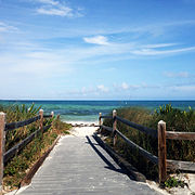
The 2.5-mile (4.0 km) natural, white sand beach was rated the #1 beach in 1992 in the United States by
Kayaks and snorkeling gear can be rented at the park, and boat trips for snorkeling on the reef are available. The park has a marina with boat slips available for overnight rental. Campsites (primitive and full hook-up) and vacation cabins are available, although reservations for the winter months can be very difficult to get.
The park is also a part of the Great Florida Birding Trail.
Hours
Florida state parks are open between 8 a.m. and sundown every day of the year (including holidays).
Climate
Bahia Honda Key has a tropical savanna climate (Aw), similar to the rest of the Florida Keys.
| Climate data for Bahia Honda Key, Florida (1991–2020 normals, extremes 2004–present) | |||||||||||||
|---|---|---|---|---|---|---|---|---|---|---|---|---|---|
| Month | Jan | Feb | Mar | Apr | May | Jun | Jul | Aug | Sep | Oct | Nov | Dec | Year |
| Record high °F (°C) | 88 (31) |
88 (31) |
92 (33) |
93 (34) |
95 (35) |
95 (35) |
97 (36) |
98 (37) |
94 (34) |
93 (34) |
88 (31) |
90 (32) |
98 (37) |
| Mean maximum °F (°C) | 82.1 (27.8) |
84.4 (29.1) |
85.9 (29.9) |
89.0 (31.7) |
90.9 (32.7) |
92.0 (33.3) |
92.9 (33.8) |
93.7 (34.3) |
91.9 (33.3) |
89.7 (32.1) |
85.1 (29.5) |
83.5 (28.6) |
94.1 (34.5) |
| Mean daily maximum °F (°C) | 74.3 (23.5) |
76.3 (24.6) |
78.4 (25.8) |
82.4 (28.0) |
85.4 (29.7) |
88.1 (31.2) |
89.9 (32.2) |
89.8 (32.1) |
87.8 (31.0) |
84.3 (29.1) |
79.1 (26.2) |
76.0 (24.4) |
82.6 (28.1) |
| Daily mean °F (°C) | 69.2 (20.7) |
70.9 (21.6) |
73.3 (22.9) |
77.1 (25.1) |
80.2 (26.8) |
82.9 (28.3) |
84.5 (29.2) |
84.3 (29.1) |
82.7 (28.2) |
79.9 (26.6) |
74.6 (23.7) |
71.3 (21.8) |
77.6 (25.3) |
| Mean daily minimum °F (°C) | 64.1 (17.8) |
65.4 (18.6) |
68.1 (20.1) |
71.7 (22.1) |
75.0 (23.9) |
77.8 (25.4) |
79.0 (26.1) |
78.8 (26.0) |
77.7 (25.4) |
75.5 (24.2) |
70.2 (21.2) |
66.6 (19.2) |
72.5 (22.5) |
| Mean minimum °F (°C) | 50.5 (10.3) |
52.5 (11.4) |
57.3 (14.1) |
64.1 (17.8) |
69.3 (20.7) |
72.4 (22.4) |
73.2 (22.9) |
73.6 (23.1) |
73.1 (22.8) |
68.8 (20.4) |
61.3 (16.3) |
57.4 (14.1) |
47.5 (8.6) |
| Record low °F (°C) | 39 (4) |
44 (7) |
51 (11) |
59 (15) |
66 (19) |
68 (20) |
71 (22) |
71 (22) |
70 (21) |
59 (15) |
54 (12) |
46 (8) |
39 (4) |
| Average precipitation inches (mm) | 1.88 (48) |
2.10 (53) |
1.68 (43) |
2.40 (61) |
3.77 (96) |
5.65 (144) |
4.77 (121) |
5.74 (146) |
7.53 (191) |
6.24 (158) |
2.23 (57) |
2.07 (53) |
46.06 (1,170) |
| Average precipitation days (≥ 0.01 in) | 5.1 | 5.1 | 4.5 | 4.8 | 5.9 | 8.3 | 10.3 | 11.5 | 13.3 | 9.9 | 5.7 | 5.9 | 90.3 |
| Source: NOAA[3][4] | |||||||||||||
Gallery
-
 View of the sunrise
 -
 View of the Bahia Honda Rail Bridge from Bahia Honda State Park
 -
 Sunset through the Old Bridge
 -

-
 Bahia Honda State Park – Old Railroad Bridge
 -
 Old Railroad Bridge
 -
 Old Railroad Bridge – view of trusses
 -
 Bottlenose dolphins swimming just off the beach
 -
 Morning view of beach
 -
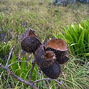 Dry seed pods
 -
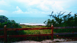
 Beach access
 -
 View in direction of Gulf of Mexico
 -
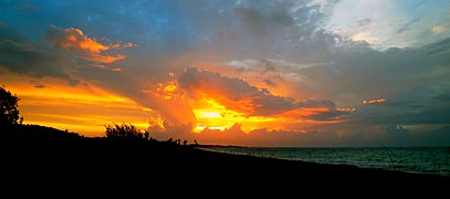
 Sunset
 -
 Panoramic view of the Bahia Honda Key and the park from the bridge


References
- ISBN 978-0-89587-280-7. Retrieved September 7, 2017.
- ^ ISBN 978-0-14-754675-3. Retrieved September 7, 2017.
- ^ "NOWData - NOAA Online Weather Data". National Oceanic and Atmospheric Administration. Retrieved August 10, 2021.
- ^ "U.S. Climate Normals Quick Access – Station: Bahia Honda SP, FL". National Oceanic and Atmospheric Administration. Retrieved February 16, 2023.