
Bahrain Island
UTC+3) | |
|---|---|
| ISO code | BH-14 |
| Official website | www |
Bahrain Island (
Geography
Most of the island of Bahrain is in a relatively shallow inlet of the
Climate
The climatic conditions of the area is arid. The average annual temperature in the area is 28 °C. The warmest month is August, when the average temperature is 38 °C and the coldest is January, with 18 °C. The average annual rainfall is 144 millimeters. The rainiest month is November, with an average of 38 mm of precipitation, and the driest is October, with 1 mm of precipitation.
Demography
Manama, the capital of the kingdom of Bahrain, is located on the northeastern tip of the Island of Bahrain. The main port, Mina Salman, is also located on the island, as are the major oil refining facilities and commercial centers.
Administration
The island is split between 3 of the Bahrain's Governorates.
Transportation
Causeways and bridges connect Bahrain to adjacent islands and the mainland of Saudi Arabia. The oldest causeway, originally constructed in 1929, links Bahrain to Al Muharraq, the third largest island. There are three causeways connecting Muharraq Island with Manama on Bahrain Island:
- Shaikh Hamad Bridge: From Muharraq City to Diplomatic Area
- Diplomatic Area
- Shaikh Khalifa Bridge: From Hidd to Juffair
At its eastern shore is lying
Gallery
-
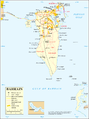 Map 1
Map 1 -
 Map Districts
 -
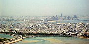 Muharraq in the foreground; Manama on Bahrain Island in the background
 -
 Bahrain Island (center) seen from space.


See also
Notes
- ^ "Case Concerning Maritime Delimitation and Territorial Questions between Qatar and Bahrain". International Court of Justice. 2001. p. 59. Archived from the original (PDF) on 2018-12-25. Retrieved 2013-06-09.
- ^ EB (1878).
- ^ EB (1911).
- ^ Geonames Bahrain
- ^ "Facts and Figures of Bahrain". Archived from the original on 2016-04-22. Retrieved 2016-04-16.
References
- Baynes, T. S., ed. (1878), , Encyclopædia Britannica, vol. 3 (9th ed.), New York: Charles Scribner's Sons, p. 240
- Holdich, Thomas Hungerford (1911), , in Chisholm, Hugh (ed.), Encyclopædia Britannica, vol. 3 (11th ed.), Cambridge University Press, p. 212