
Baker Island
Nickname: New Nantucket | |
|---|---|
 U.S. Fish and Wildlife Service aerial view of Baker Island | |
 Baker Island Location of Baker Island in the Pacific Ocean | |
| Geography | |
| Location | Pacific Ocean |
| Coordinates | 0°11′45″N 176°28′45″W / 0.19583°N 176.47917°W |
| Area | 2.1 km2 (0.81 sq mi) |
| Length | 1.81 km (1.125 mi) |
| Width | 1.13 km (0.702 mi) |
| Coastline | 4.8 km (2.98 mi) |
| Highest elevation | 8 m (26 ft) |
| Administration | |
| Status | Unincorporated |
| Demographics | |
| Population | 0 |
| Additional information | |
| Time zone |
|
| Designated | 1974 |
Baker Island, formerly known as New Nantucket,[1] is an uninhabited atoll just north of the Equator in the central Pacific Ocean about 3,090 km (1,920 mi) southwest of Honolulu. The island lies almost halfway between Hawaii and Australia. Its nearest neighbor is Howland Island, 42 mi (68 km) to the north-northwest; both have been claimed as territories of the United States since 1857, though the United Kingdom considered them part of the British Empire between 1897 and 1936.
The island covers 2.1 km2 (0.81 sq mi),
The island now forms the Baker Island National Wildlife Refuge and is an
Description
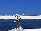
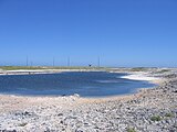
A cemetery and rubble from earlier settlements are located near the middle of the west coast, where the boat landing area is located. There are no ports or harbors, with anchorage prohibited offshore. The narrow fringing reef surrounding the island can be a maritime hazard which makes it difficult to easily reach shore, so there is a day beacon near the old village site. Baker's abandoned World War II runway, 5,463 ft (1,665 m) long, is completely covered with vegetation and is unserviceable.[4]
The United States claims an exclusive economic zone of 200 nautical miles (370 km) and territorial sea of 12 nmi (22 km) around Baker Island.
During a 1935–1942 colonization attempt, the island was most likely on Hawaii time, which was then 10.5 hours behind
History

Baker was discovered in 1818 by Captain Elisha Folger of the Nantucket whaling ship Equator, who called the island "New Nantucket". In August 1825 Baker was sighted by Captain Obed Starbuck of the Loper, also a Nantucket whaler. The island is named for Michael Baker, who visited the island in 1834.[6] Other references state that he visited in 1832, and again on August 14, 1839, in the whaler Gideon Howland, to bury an American seaman.[7] Captain Baker claimed the island in 1855, then he sold his interest to a group who later formed the American Guano Company.[8][9]
The United States took possession of the island in 1857, claiming it under the Guano Islands Act of 1856.[10] Its guano deposits were mined by the American Guano Company from 1859 to 1878. Laborers for the mining operations came from around the Pacific, including from Hawaiʻi; the Hawaiian laborers named Baker Island "Puaka‘ilima" ('the ‘ilima flower').[11] As an example of the scale of the guano mining and its destination the following ship movements were reported in late 1868.[12]
- British ship Montebello, Capt Henderson, arrived Aug 17th 104 days from Liverpool, loaded 650 tons guano, departed for Liverpool 9th Sep.
- American ship Eldorado, Capt Woodside, arrived Sept 14th from Honolulu, loaded 1550 tons guano, departed for Liverpool Oct 5th.
- British bark Florence Chipman, Capt Smith, arrived Oct 13th from Rio, loaded 1400 tons guano, departed for Liverpool Nov 5th.
On February 27, 1869, the British ship Shaftsbury under Captain John Davies, which had arrived at Baker's Island on 5 February from Montevideo, was wrecked after being driven onto the reef by a sudden wind shift and squall from the northwest, dragging her moorings with her.[13] American ship Robin Hood was destroyed by fire while loading on 30 August 1869.[14]
.jpg)
.jpg)
.jpg)
On 7 December 1886, the American Guano Company sold all its rights to the British firm John T. Arundel and Company, which made the island its headquarters for guano digging operations in the Pacific from 1886 to 1891. Arundel applied in 1897 to the British Colonial Office for a licence to work the island on the presumption that the U.S. had abandoned their claim. The United Kingdom then considered Baker Island to be a British territory, although they never formally annexed it. The United States raised the question at the beginning of the 1920s and after some diplomatic exchanges, in 1935 they launched the American Equatorial Islands Colonization Project and in May 1936 issued Executive Order 7358 to clarify their sovereignty.[15]
This short-lived attempt at colonization, via the American Equatorial Islands Colonization Project, began when American colonists arrived aboard
Airfield
Baker Island Light | |
 | |
| Location | Baker Island, United States Minor Outlying Islands, US |
|---|---|
| Coordinates | 0°11′45″N 176°29′03″W / 0.19578°N 176.48428°W |
| Tower | |
| Constructed | 1935 |
| Construction | brick |
| Height | 5 m (16 ft) |
| Shape | cylindrical tower, no lantern[18] |
| Markings | white |
| Light | |
| Deactivated | 1942 |
On August 11, 1943, a US Army defense force arrived on Baker Island as part of the
LORAN Station Baker
LORAN radio navigation station Baker was a radio operations base in operation from September 1944 to July 1946. The station unit number was 91 and the radio call sign was NRN-1.[21]
Flora and fauna
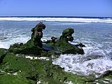
Baker island has no natural fresh water sources, lacks in rainfall, is over 25 feet wide, and is remote. It is a wildlife refuge, and is completely uninhabited despite its rich history. It is treeless, with sparse vegetation consisting of four kinds of grass,
National Wildlife Refuge
On June 27, 1974, Secretary of the Interior
Environmental challenges include abandoned military debris from
Public entry to the island is only by special use permit from the U.S. Fish and Wildlife Service and it is generally restricted to scientists and educators, though do provide tour packages per year from early June to Mid-August. Visitation without authorized permission, swimming, fishing, and fires are strictly prohibited, and the atoll is only visited during daytime. Scuba diving is restricted only to scientists of the
Ruins and artifacts
Debris from past human occupation is scattered throughout the island and in offshore waters. Most is from the U.S. military occupation of the island from 1942 to 1946. The most noticeable remnant is the 5,400-by-150-foot (1,646 by 46 m) airstrip. It is completely overgrown with vegetation and is unusable.[4] The West Coast section of the island has a day beacon, which has not been managed since World War II, as it is mainly used by both albatross birds and hermit crabs for breeding and to a way to seek out shade & to help the U.S. Fish and Wildlife Service locate the atoll. In the northeast section, apparently the main camp area, are the remains of several buildings and heavy equipment. Five wooden antenna poles about 40 feet (12 m) in height remain standing in the camp. Debris from several crashed airplanes and large equipment such as bulldozers are scattered around the island and underwater. Numerous bulldozer excavations containing the remnants of metal, fuel and water drums are scattered about the north central portion and northern edge of the island. The Navy reported the loss of 11 landing craft in the surf during World War II.[30]
Gallery
-
 Baker Island coastline with red-footed booby
 -
 Fish and Wildlife sign
 -
 Hermit crabs taking shade in day beacon
 -
 Settlement remains, radio mast in background
 -
 Masked booby on gravestone
 -
 Brown noddies with radio masts in background
 -
 Landing craft wreckage on Baker Island coast
 -
 Baker Island satellite image


See also
- 64th Coast Artillery (United States)
- History of the Pacific Islands
- Howland and Baker Islands, includes coverage of the Howland-Baker EEZ
- List of Guano Island claims
- List of islands of the United States
- List of lighthouses in the United States Minor Outlying Islands
References
- ISBN 9780824846794.
- ^ a b c "United States Pacific Island Wildlife Refuges". The World Factbook (2024 ed.). Central Intelligence Agency. Retrieved April 25, 2014. (Archived 2014 edition.)
- ISBN 9780824846794.
- ^ a b "Baker Island : History". U.S. Fish & Wildlife Service. Retrieved September 23, 2018.
- ^ Long, Elgen M.; Long, Marie K. (2000). Amelia Earhart: the mystery solved. Simon & Schuster. p. 206.
Thursday, July 1, [1937] ... Howland Island was using the 10+30 hour time zone—the same as Hawaii standard time.
- ^ Henry Evans Maude (1968). Of islands and men: studies in Pacific history. Oxford University Press.
- ^ Bryan, 1941
- ^ "GAO/OGC-98-5 - U.S. Insular Areas: Application of the U.S. Constitution". U.S. Government Printing Office. November 7, 1997. Archived from the original on September 27, 2013. Retrieved March 23, 2013.
- ^ "The Guano Companies in Litigation--A Case of Interest to Stockholders". The New York Times. May 3, 1865. Archived from the original on May 10, 2013. Retrieved March 23, 2013.
- ^ Edwin Horace Bryan (1941). American Polynesia: coral islands of the Central Pacific. Honolulu, Hawaii: Tongg Publishing Company.
- .
- ^ Baker's Island Report, H.L.R. Johnson, Pacific Commercial Advertiser, 19 Dec 1868
- ^ The loss of the British ship Shaftsbury, Pacific Commercial Advertiser, 12 Jun 1869
- ^ Report from the guano islands, Pacific Commercial Advertiser, 25 Dec 1869
- ^ Hull, Cordell; Roosevelt, Franklin D. (1936). "Memorandum of Secretary of State Cordell Hull to the president, February 18, 1936". Hyde Park, N.Y.: Franklin D. Roosevelt Library. Archived from the original on January 9, 2010. Retrieved March 18, 2010.
- ^ "Baker Island". Any Travels. Archived from the original on July 23, 2011. Retrieved February 5, 2016.
- ^ "Sixteenth Census of the United States: Population, Volume I, Number of Inhabitants, Hawaii (Table 4)", United States census, 1940; Washington, D.C.; page 1211,. Retrieved on October 29, 2021.
- ^ Rowlett, Russ. "Lighthouses of U.S. Pacific Remote Islands". The Lighthouse Directory. University of North Carolina at Chapel Hill. Retrieved November 7, 2016.
- ISBN 9780313313950.
- ISBN 9780252070372.
- ^ "Loran Station Baker - loran-history.info". Archived from the original on August 24, 2010. Retrieved December 3, 2010. LORAN STATION BAKER ISLAND 0 11 46.23 N 176 28 26.14 W
- ^ U.S. Dept. of Interior. Baker Island. Archived April 19, 2012, at the Wayback Machine Retrieved July 6, 2008.
- ^ "Baker Island". BirdLife Data Zone. BirdLife International. 2021. Retrieved January 22, 2021.
- ^ "Redirect Page". www.fws.gov. Archived from the original on June 17, 2017. Retrieved April 29, 2018.
- ^ White, Susan (August 26, 2011). "Welcome to Baker Island National Wildlife Refuge". U.S. Fish and Wildlife Service. Archived from the original on March 27, 2012. Retrieved March 4, 2012.
- ^ Bush, George W. (January 6, 2009). "Establishment of the Pacific Remote Islands Marine National Monument: A Proclamation by the President of the United States of America". White House. Archived from the original on February 23, 2011. Retrieved March 4, 2012.
- ^ "Baker Island National Wildlife Refuge History". U.S. Fish and Wildlife Service. Archived from the original on May 28, 2013. Retrieved April 23, 2013.
- ^ Palawski, Donald (August 2007). "Baker Island National Wildlife Refuge: Draft Comprehensive Conservation Plan and Environmental Assessment §3.12" (PDF). U.S. Fish and Wildlife Service. Archived (PDF) from the original on July 19, 2012. Retrieved March 5, 2012.
- ^ "Baker Island National Wildlife Refuge". U.S. Fish and Wildlife Service. Archived from the original on May 16, 2013. Retrieved April 23, 2013.
- ^ "Baker Island National Wildlife Refuge: Draft Comprehensive Conservation Plan and Environmental Assessment" (PDF). Pacific Remote Islands National Wildlife Refuge Complex. August 2007. Archived (PDF) from the original on May 11, 2009. Retrieved December 3, 2010.
External links
- Baker Island National Wildlife Refuge
- Baker Island. This article incorporates material from The World Factbook 2000.
| |
| |
| |
| |
| |
| |
| |
| International | |
|---|---|
| People | |
| Other | |
| Baker Island Day Beacon | |