
Banat
Banat
| |
|---|---|
Historical region | |
 Map of the region of Banat | |
| Coordinates: 45°42′00″N 20°54′00″E / 45.7000°N 20.9000°E | |
| Country | |
| Largest city | Timișoara |
| Area | |
| • Total | 28,526 km2 (11,014 sq mi) |
| Population (2011 est.) | |
| • Total | 1,700,000 |
| • Density | 60/km2 (150/sq mi) |

Banat (
The region's historical ethnic diversity was severely affected by the events of
Name
During the Middle Ages, the term "
At the time of the medieval Hungarian kingdom, the territory of modern Banat appeared in written sources as Temesköz (first mentioned in 1374).[6] The Hungarian name mainly referred to the lowland areas between the Mureș, Tisza and Danube rivers.[6] Its Ottoman name was "Eyalet of Temeşvar" (later "Eyalet of Yanova"). During the Turkish occupation, the territory of Temesköz (Banat) was also called "Rascia" ("the country of the Serbs", 1577).[7] For Romanians, the region was also known as Temișana.[8]
In the
The name "Banat" is similar in different languages of the region; Romanian: Banat, Serbo-Croatian: Банат/Banat, Hungarian: Bánság or Bánát, Bulgarian: Банат, Czech: Banát, German: Banat, Greek: Βανάτο/Vanáto, Slovak: Banát, Turkish: Banat, Ukrainian: Банат. Some of these languages would also have other terms, from their own frame of reference, to describe this historical and geographic region.
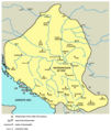
Geography

Banat is defined as the part of the
The Romanian Banat is mountainous in the south and southeast, while in the north, west and southwest it is flat and in some places marshy.
The relief of Serbian Banat is monotonous, except for a few morphological units: the Vršac Mountains, the Bela Crkva basin and the east Banat alluvium. The largest stretch of sand in Europe, today stabilized and covered with vegetation, Deliblatska Peščara, also lies in Serbian Banat.[12]
Climate
The climate of Banat is predominantly temperate (Cfb, according to Köppen classification), with a northeastward increase of continental and orographic effects (Dfb). Frequent cyclones from the Mediterranean cause positive precipitation anomalies especially in the western parts and, due to the maritime influence, winters are mild and short, but when northeastern conditions prevail, harsh frosts may occur. Mean annual temperatures range between 12 °C (with average summer temperatures above 22 °C in July) and 6 °C towards the eastern highlands.[13] Besides, temperature inversions occur in the valleys and in the depressions of the Banat Hills, the bottom being colder than the slopes. The thermal and dynamic convection produced on the slopes causes greater cloudiness throughout the year; humidity and precipitation are higher.[14]
Hydrography

Considering the low and undesiccated land, there is a relatively large number of watercourses in Banat. The rivers bordering the area and delimiting it from the rest of the territories are
The
The Bega/Begej springs from the Poiana Ruscă Mountains, crosses the area of Făget and Lugoj, passes through Timișoara, then descends through a channel, flowing into the Tisza, at Titel.[15] Bega and Aranca/Zlatica flow into the Tisza, and Timiș with its tributaries, such as Pogăniș, Bârzava/Brzava, Caraș/Karaš and Nera, flow into the Danube.
There are no large natural lakes. In the past, there were many lakes, ponds and swamps in Banat, which were drained by land reclamation carried out at the end of the 18th century and the beginning of the 19th century. There are bigger lakes only south of Zrenjanin.[16]
History
| History of Banat |
|---|
 |
| Historical Banat |
|
| Modern Romanian Banat |
| Modern Serbian Banat |
| Modern Hungarian Banat |
|
The first known inhabitants of present-day Banat were the
In 273 AD Emperor Aurelian withdrew the Roman Army from Dacia. The area fell into the hands of foederati such as the Sarmatians (Iazyges, Roxolani, Limigantes) and later the Goths, who also took control of other parts of Dacia.
-
 Ancient Indo-European peoples in Banat
 -
 Ancient Roman cities in Banat


Migration Period and Early Middle Ages
The
One governing center of the Avars was formed in the region, which played an important role in the Avar–Byzantine wars. An inscription on one of the vessels from the
In 895, the
According to Gesta Hungarorum chronicle, a local ruler known as Glad ruled over Banat and his army was formed by Vlachs, Bulgarians, and Cumans.[17] Ahtum was another early-11th-century ruler in the territory now known as Banat. His primary source is the Long Life of Saint Gerard, a 14th-century hagiography. Chanadinus, Ahtum's former commander-in-chief, defeated and killed Ahtum, occupying his realm.[17]
Hungarian administration (11th–16th centuries)

Banat was administered by the First Bulgarian Empire from the 9th to the 11th century, but that control gradually migrated to the Kingdom of Hungary which administered it from the 11th century up until 1552, when the region of Temesvár (today Timișoara) was captured by the Ottoman Empire.
The area of the Timiș river was not the land of the Hungarian royal tribe. When nomadic Hungarians came to Transylvania there was no direct Bulgarian political rule there..
In 1233, under the Kingdom of Hungary administration, the Banate of Severin, a military frontier area was formed, including some eastern parts of the modern Banat. In the 14th century, the region became of priority concern to the Kingdom, as the southern border of Banat was the most important defensive line against Ottoman expansion from the southeast.
-
 Duchy of Glad, 9th century
 -
 Duchy ofAhtum, 11th century
 -
 Counties of the Kingdom of Hungary in present-day Banat in the 14th century
 -
 Banate of Severin


Ottoman administration (1552–1716)

The
Not all of Banat fell immediately under Turkish rule. Eastern regions around
In the spring of 1594, shortly after the beginning of the
In the middle of the 17th century, the territory of
During
-
 Jurisdiction of Serbian Patriarchate in the 16th and 17th centuries
 -
 Banate of Lugoj and Caransebeșin 1568
 -
 Uprising in Banat in 1594
 -
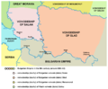
 Eyalet of Temeşvarin the mid-17th century
 -
 Eyalet of Temeşvarand the surrounding regions in 1683
 -
 Eyalet of Temeşvar, from 1699 to 1716


Habsburg administration (1716–1867)


At the beginning of the next
In 1738, over 50 Romanian villages from Serbia and Banat were destroyed and dwellers murdered by Austrians and Serb militia during a revolt of Romanians.
During the Ottoman rule, parts of Banat had a low population density due to years of warfare, and some local residents also died during Habsburg-Ottoman wars and Prince Eugene of Savoy's conquest. Much of the area had reverted to nearly uninhabited marsh, heath and forest. Count
Similarly, a minority coming from French-speaking or linguistically mixed communes in
In 1779, the Banat region was incorporated into the
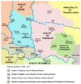
After the Revolution of 1848–1849, Banat (together with
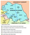
The Serbian Banat (Western Banat) was part of
Hungarian administration (1867–1918)
In 1867, after the Austro-Hungarian compromise the territory returned again to Hungarian administration. After 1871, the former
-
 Proclaimed borders of Serbian Vojvodina in 1848 (including Western Banat)
 -
 Voivodeship of Serbia and Temes Banat(1849–1860)
 -

.png)

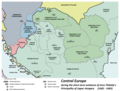
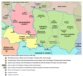
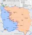
The Banat Question at the end of First World War
In 1918, the Banat Republic was proclaimed in Timișoara in October, and the government of Hungary recognized its independence. However, it was short-lived. After just two weeks, Serbian troops invaded the region and took control. From November 1918 to March 1919, western and central parts of Banat were governed by Serbian administration from Novi Sad, as part of the Banat, Bačka and Baranja province of the Kingdom of Serbia and newly formed Kingdom of Serbs, Croats and Slovenes (which was later renamed as Yugoslavia).
In the wake of the Declaration of
At the dissolution of Austria-Hungary, the delegates of the Romanian and some German communities voted for union with Romania during the Great National Assembly of Alba Iulia;[26] the delegates of the Serbian, Bunjevac and other Slavic and non-Slavic communities (including some Germans) voted for union with Serbia during the Great People's Assembly of Serbs, Bunjevci and other Slavs in Banat, Bačka and Baranja;[citation needed] while the Hungarian minority remained loyal to the government in Budapest. Besides these declarations, no other plebiscite was held.
-
 Self-proclaimed Banat Republic in 1918
 -
 Situation around Banat in 1918
 -
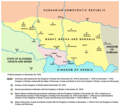
 Situation around Banat in 1919–1921
 -
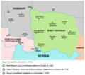
 Division of Banat in 1919–1923


Romanian Banat since the First World War


In 1938, the counties of Timiș-Torontal, Caraș, Severin, Arad and Hunedoara were joined to form ținutul Timiș, which roughly encompassed the area typically called Banat in Romania.
On 6 September 1950, the province was replaced by the Timișoara Region (formed by the present-day counties of Timiș and Caraș-Severin). In 1956, the southern half of the existing Arad Region was incorporated to the Timișoara Region. In December 1960, the Timișoara Region was renamed the Banat Region.
On 17 February 1968, a new territorial division was made and today's Timiș, Caraș-Severin and Arad counties were formed.
Since 1998, Romania has been divided into eight
Serbian Banat since the First World War


The region was claimed by the
During World War II, the Axis Powers occupied this area and partitioned it. Nazi Germany had been intent on expanding into eastern Europe to incorporate what it called the
Since 1944–1945, the Serbian Banat (together with Bačka and
Hungarian Banat since the First World War
The Hungarian Banat consists of a small northern part of the region, which is part of the Csongrád-Csanád County of Hungary and is made up of seven villages and the district of Szeged, Újszeged. The Hungarian part of Banat used to be the northernmost region of the Torontál County in the Kingdom of Hungary.
Administrative organization
In Romania, Banat includes all of Timiș and Caraș-Severin counties (with the exception of Băuțar), Arad County (only the part south of the Mureș), the Mehedinți panhandle (several localities from the traditional Banat area disappeared under the waters of the Porțile de Fier reservoir) and Hunedoara County (only the villages of Pojoga and Sălciva).[8]
The Serbian Banat includes the part located east of the
In Hungary, there is only a small part of Csongrád-Csanád County, namely the part located in the southern angle formed by the Tisza and Mureș rivers, up to the state border with Romania and Serbia.[8]
Largest cities
The following table lists the cities in Banat with a population greater than 10,000 (2022).[27][28] Some cities that are not historically part of Banat expanded into this region during the 20th century, so that today some districts lie in the historical Banat: Arad (Aradu Nou), Belgrade (Palilula) and Szeged (Újszeged).

|
| Timișoara |

|
| Pančevo |
.jpg)
|
| Zrenjanin |

|
| Reșița |

|
| Lugoj |

|
| Kikinda |
| City | Population | Country | Administrative | Historic subregion | ||
|---|---|---|---|---|---|---|
| 1 | Timișoara | 250,849 | Timiș County | Romanian Banat | ||
| 2 | Pančevo (Панчево) | 73,401 | South Banat District | Serbian Banat | ||
| 3 | Zrenjanin (Зрењанин) | 67,129 | Central Banat District | Serbian Banat | ||
| 4 | Reșița | 55,181 | Caraș-Severin County | Romanian Banat | ||
| 5 | Lugoj | 34,462 | Timiș County | Romanian Banat | ||
| 6 | Kikinda (Кикинда) | 32,084 | North Banat District | Serbian Banat | ||
| 7 | Vršac (Вршац) | 31,946 | South Banat District | Serbian Banat | ||
| 8 | Caransebeș | 21,133 | Caraș-Severin County | Romanian Banat | ||
| 9 | Dumbrăvița | 20,014 | Timiș County | Romanian Banat | ||
| 10 | Giroc | 17,999 | Timiș County | Romanian Banat | ||
| 11 | Bocșa | 12,949 | Caraș-Severin County | Romanian Banat | ||
| 12 | Kovin (Ковин) | 11,623 | South Banat District | Serbian Banat | ||
| 13 | Novi Bečej (Нови Бечеј) | 10,967 | Central Banat District | Serbian Banat | ||
| 14 | Sânnicolau Mare | 10,627 | Timiș County | Romanian Banat | ||
| 15 | Jimbolia | 10,179 | Timiș County | Romanian Banat | ||
| 16 | Lipova | 10,040 | Arad County | Romanian Banat |
Demographics
| Year | Total | Romanians | Serbs | Hungarians | Germans | Others |
|---|---|---|---|---|---|---|
| Romanian Banat[29] | ||||||
| 1910 | 984,849 | 515,485 (52.3%) | 48,733 (4.9%) | 120,959 (12.3%) | 252,802 (25.7%) | 46,870 (4.8%) |
| 1931 | 961,808 | 532,589 (55.3%) | 36,491 (3.8%) | 97,854 (10.2%) | 246,354 (25.6%) | 48,520 (5.1%) |
| 1956 | 972,490 | 648,925 (66.7%) | 31,156 (3.2%) | 86,592 (8.9%) | 147,275 (15.1%) | 58,542 (6.1%) |
| 1992 | 1,142,710 | 954,846 (83.5%) | 15,622 (1.4%) | 67,497 (5.9%) | 30,843 (2.7%) | 73,902 (6.5%) |
| 2002 | 1,078,190 | 916,492 (85.1%) | 20,937 (1.9%) | 59,691 (5.5%) | 21,083 (1.9%) | 59,987 (5.6%) |
| Serbian Banat[29] | ||||||
| 1910 | 580,957 | 76,398 (13.1%) | 232,009 (40.0%) | 109,510 (18.8%) | 133,495 (23.0%) | 29,175 (5.1%) |
| 1931 | 586,906 | 61,743 (10.5%) | 271,900 (46.3%) | 90,670 (15.4%) | 116,900 (20.0%) | 45,693 (7.8%) |
| 1953 | 631,485 | 55,439 (8.8%) | 388,268 (61.5%) | 110,030 (17.4%) | 6,277 (1.0%) | 69,911 (11.3%) |
| 1992 | 690,314 | 33,795 (4.9%) | 460,929 (66.7%) | 72,508 (10.5%) | — | 124,072 (17.9%) |
| 2022 | 540,041 | 21,082 (3.90%) | 453,612 (83.99%) | 101,857 (18.86%) | 854 (0.1%) | 74,059 (12.4%) |
| Hungarian Banat[29] | ||||||
| 1910 | 16,758 | 85 (0.5%) | 3,588 (21.4%) | 11,683 (69.7%) | 1,248 (7.5%) | 154 (0.9%) |
| 1930 | 18,483 | — | 471 (2.5%) | 16,967 (91.9%) | 1,045 (5.6%) | — |
| 1949 | 19,334 | — | — | 19,024 (98.4%) | — | 310 (1.6%) |
| 1990 | 18,601 | — | — | 18,601 (100%) | — | — |
| 2001 | 20,139 | — | — | 20,139 (100%) | — | — |
Romanian Banat
Serbian Banat
In most cities and municipalities of the Serbian Banat, the majority population is Serbian. Hungarians make up the majority of the population in Čoka (Csóka), and Slovaks make up the relative majority in the ethnically mixed municipality of Kovačica. Romanians make up the majority in certain settlements, and Czechs in Češko Selo.
Hungarian Banat
In the Hungarian part of Banat, the majority population is Hungarian, but in some villages in the region (Deszk/Деска, Szőreg/Сириг, Újszentiván/Нови Сентиван) there is also a Serbian minority.
Symbols
The traditional heraldic symbol of Banat is a lion, which is nowadays present in both the coat of arms of Romania and the coat of arms of Vojvodina. It is assumed that the Banat lion has its origin in the Cuman lion.[32]
The current coat of arms of the Romanian Banat was designed in 1921, after the union of the Banat with the Kingdom of Romania, by the heraldist József Sebestyén by combining some elements from the coats of arms of Temes and Krassó counties from 1779 to represent the "Romanian Banat of Severin".[32] It consists of a red shield in which is represented a golden lion rampant emerging from a golden bridge with two arched openings, built of carved stone, over an azure river. According to its author, "the lion is the old (Cuman) element, the bridge is the new element, Trajan's Bridge over the Danube".[32] The coat of arms from 1921 was modified in 1992 by adding a sabre in the right paw,[33] recalling the backsword of Pál Kinizsi, count of Temes.
Serbs use the seal of the Velika Kikinda District of 1774 to represent Banat.[32] It also features a golden lion rampant with a sabre in the right paw and a severed Turkish head in the left one.
Notable people
- Radomir Antić (1948–2020), football player and coach
- Mihajlo Idvorski Pupin(1858–1935), Serbian physicist, physical chemist and philanthropist
- Iolanda Balaș (1936–2016), high jumper
- Béla Bartók (1881–1945), composer, pianist and ethnomusicologist
- Miodrag Belodedici (b. 1964), football player and coach
- Dejan Bodiroga (b. 1973), basketball player
- Nicu Covaci (b. 1947), singer
- Sava II Branković, Orthodox priest and Saint
- Vuk Drašković (b. 1946), writer and politician
- Nicolae Kovács (b. 1911), fotballer
- Nikola Grbić (b. 1973), volleyball player and coach
- Vladimir Grbić (b. 1970), volleyball player
- Arnold Hauser (1892–1978), art historian and sociologist
- Aleksa Janković (1806-1869), Prime Minister of Serbia, born in Timișoara
- Ion Ivanovici (1845–1902), military band conductor and composer
- Francesco Illy (1892–1956), inventor of coffee machine and businessman
- Đura Jakšić (1832–1878), painter, poet, storyteller and playwright
- Károly Kerényi (1897–1973), philologist and father of Greek mythology studies
- Ștefan Kovács (1920–1995), football player and coach
- Nikolaus Lenau (1802–1850), poet
- Bela Lugosi (1882–1956), actor
- Herta Müller (b. 1953), novelist, poet and essayist
- Dorinel Munteanu (b. 1968), football player and coach
- Dositej Obradović (1742-1811), writer
- Ana Pacatiuș (born 1939), folksinger
- Vasko Popa (1922–1991), poet
- Julieta Szönyi (b. 1949), actor
- Ștefan Szönyi (1913–1967) (hu; ro) painter
- Döme Sztójay (1883–1946), soldier and diplomat
- Zoran Tošić (b. 1987), football player
- Traian Vuia (1872–1950), inventor and aviation pioneer
- Zvonimir Vukić (b. 1979), football player
- Ivana Vuleta(b. 1990), long jumper
- Johnny Weissmuller (1904–1984), swimmer, water polo player and actor
References
Citations
- ^ "Banat". Merriam-Webster.com Dictionary.
- Webster's New World College Dictionary.
- ^ a b c d Docea, Vasile (2007). "A la recherche du Banat disparu". In Babeți, Adriana (ed.). Le Banat: un Eldorado aux confins (PDF). Cultures d'Europe centrale – Hors série № 4. Université Paris-Sorbonne (Paris IV): Centre Interdisciplinaire de Recherches Centre-Européennes. pp. 53–63.
- ^ "Banat". Encyclopedia Britannica.
- OCLC 19845725.
- ^ a b Temesköz.
{{cite book}}:|work=ignored (help) - ^ Pálffy, Géza (2001). "The Impact of the Ottoman Rule on Hungary" (PDF). Hungarian Studies Review. 28 (1–2): 109–132.
- ^ a b c d Both, Ștefan (3 February 2013). "Banatul, un veritabil Eldorado al Europei. Etimologia numelui regiunii". Adevărul.
- ^ ISBN 978-973-52-0201-9. Archived from the original(PDF) on 2023-03-27. Retrieved 2022-12-12.
- ^ Forțiu, Sorin. "Și totuși, care este suprafața Banatului?" (PDF).
- ^ Bizerea, Marius (1975). "Banatul, ca unitate și individualitate istorico-geografică în cadrul pământului locuit de români". Tibiscus. Etnografie. Timișoara: Muzeul Banatului: 7–25.
- ^ Marković, Jovan Đ.; Pavlović, Mila A. (1995). Географске регије Југославије (Србија и Црна Гора). Belgrade: Savremena administracija.
- S2CID 233887936.
- ^ a b Hațegan, Ioan; Savulov, Lucia (1997). "Banatul medieval" (PDF). Analele Banatului. 5: 179–216.
- ^ a b Silaghi, Vali (13 April 2013). "Râurile înfrățite din Banat: cum și-a căpătat Bega numele". Adevărul.
- ^ Marković, Jovan Đ. (1966). Географске области Социјалистичке Федеративне Републике Југославије. Belgrade: Zavod za izdavanje udžbenika Socijalističke Republike Srbije.
- ^ a b Madgearu, Alexandru (1998). "Geneza și evoluția voievodatului bănățean din secolul al X-lea". Studii și materiale de istorie medie. 16: 191–207.
- ISBN 978-90-47-42880-0.
- ^ a b Pálffy 2021, p. 85.
- ^ Gavrilović 1993, p. 44.
- ^ Lemajić 2015, pp. 218–221.
- ^ Ćirković 2004, pp. 141–142.
- ^ Picot, Émile (1873). Les Serbes de Hongrie, leur histoire, leurs priviléges, leur église, leur état politique et social (PDF). Prague: Grégr & Dattel. p. 113.
- ^ a b Chisholm, Hugh, ed. (1911). . Encyclopædia Britannica (11th ed.). Cambridge University Press.
- S2CID 248974401.
- ^ "The Resolution of the National Assembly in Alba-Iulia on the 18th of November/the 1st of December". Institutul Național al Patrimoniului.
- ^ "Romania: Counties and Major Cities". City Population.
- ^ "Serbia: Regions, Districts and Major Cities". City Population.
- ^ S2CID 251603657.
- ISSN 2501-1359.
- ISSN 0025-8296.
- ^ ISSN 2285-5130.
- ^ "Lege nr. 102 din 21 septembrie 1992". Portal Legislativ.
Sources
- Bataković, Dušan T., ed. (2005). Histoire du peuple serbe. Lausanne: L'Âge d'Homme. ISBN 9782825119587.
- Bocșan, Nicolae (2015). "Illyrian privileges and the Romanians from the Banat" (PDF). Banatica. 25: 243–258.
- Ćirković, Sima M. (2004). The Serbs. Blackwell Publishing. ISBN 0-631-20471-7.
- Engel, Pál (2001). The Realm of St Stephen: A History of Medieval Hungary, 895-1526. London: I.B. Tauris. OCLC 56676014.
- Förster, Horst; Wolf, Josef (2004). Entwicklung der ethnischen Struktur des Banats 1890 - 1992. Borntraeger. ISBN 978-3-443-28519-7.
- Fodor, Pál; Dávid, Géza, eds. (2000). Ottomans, Hungarians, and Habsburgs in Central Europe: The Military Confines in the Era of Ottoman Conquest. Brill. ISSN 1380-6076.
- Gavrilović, Slavko (1993). "Serbs in Hungary, Slavonia and Croatia in struggles against the Turks (15th-18th centuries)". In Samardžić, Radovan; Duškov, Milan (eds.). Serbs in European Civilization. NOVA. pp. 41–54. ISBN 86-7583-015-7.
- Ilić-Mandić, Jelena (2020). "The Local Elite in Central Government Service: Banat Military Frontier Officers in the 18th Century". The Habsburg State-wide and the regions in the Southern Danube basin (16th-20th centuries). Wien: New academic press. pp. 99–121.
- Ilić-Mandić, Jelena (2021). "Forging the Wallachian Military Border, 1769-1772" (PDF). Banatica. 31 (2): 251–273.
- Ilić-Mandić, Jelena (2022a). "Making the Border and Frontiersmen: Militarisation in Temeswarer Banat, 1764-1775". In Magina, Livia; Fodor, Gelu; Cîmpeanu, Liviu; Ardelean, Florin Nicolae (eds.). From medieval frontiers to early modern borders in Central and South-Eastern Europe. Berlin: Peter Lang Publishing. pp. 207–228. S2CID 249809935.
- Ilić-Mandić, Jelena (2022b). "The Military Frontier and Emigration Challenges in the 18th Century" (PDF). Migrations in the Slavic Cultural Space From the Middle Ages to the Present Day. Lódź: Wydawnictwo Universytetu Lódzkiego. pp. 45–62.
- Ingrao, Charles; Samardžić, Nikola; Pešalj, Jovan, eds. (2011). The Peace of Passarowitz, 1718. West Lafayette, Indiana: Purdue University Press. ISBN 978-1-55753-594-8.
- Isailović, Neven (2016). "Living by the Border: South Slavic Marcher Lords in the Late Medieval Balkans (13th–15th Centuries)". Banatica. 26: 105–117. ISSN 1222-0612.
- Ivanović, Miloš; Isailović, Neven (2015). "The Danube in Serbian-Hungarian Relations in the 14th and 15th Centuries". Tibiscum. 5: 377–394.
- Ivić, Pavle, ed. (1995). The History of Serbian Culture. Porthill Publishers. ISBN 9781870732314.
- Krstić, Aleksandar; Isailović, Neven (2015). "Serbian Language and Cyrillic Script as a Means of Diplomatic Literacy in South Eastern Europe in 15th and 16th Centuries". Yearbook of "George Barițiu" Institute of History (54). Cluj-Napoca: 185–195. ISSN 1584-4390.
- Krstić, Aleksandar (2019). "Familiares of the Serbian despots in and from the territory of Banat (1411–1458)". In Zoltan, Iustin (ed.). Politics and Society in the Central and South-Eastern Europe (13th-16th centuries). Cluj-Napoca: Mega. pp. 93–109.
- Lemajić, Nenad (2015). "The Serbian Population of the Banat and the Western Mureș Basin in the 15th and 16th Centuries (and its Local and Military Leaders)". In Đura, Hardi; et al. (eds.). The Cultural and Historical Heritage of Vojvodina in the Context of Classical and Medieval Studies. Novi Sad: Faculty of Philosophy. pp. 205–222. OCLC 1128942908.
- Mitrović, Andrej (1969). Jugoslavija na konferenciji mira 1919-1920. Zavod za izdavanje udžbenika Socijalističke Republike Srbije.
- Mitrović, Andrej (1975). Razganičenje Jugoslavije sa Madarskom i Rumunijom 1919-1920: prilog proučavanju jugoslavenske politike na konferenciji mira u Parizu. Institut za izučavanje istorije Vojvodine.
- Pálffy, Géza (2021). Hungary Between Two Empires 1526–1711. Bloomington: Indiana University Press. ISBN 978-0-253-05464-7.
- Pešalj, Jovan (2010). "Early 18th-Century Peacekeeping: How Habsburgs and Ottomans Resolved Several Border Disputes after Karlowitz". In Mitev, Plamen; et al. (eds.). Empires and Peninsulas: Southeastern Europe between Karlowitz and the Peace of Adrianople, 1699–1829. Berlin: LIT. pp. 29–42. ISBN 978-3-643-10611-7.
- Schatteles, Tiberiu (2013). Evreii din Timișoara în perspectivă istorică. Hasefer. ISBN 9789736302671.
| Banat |
|
|---|---|
| Dobruja |
|
| Moldavia |
|
| Transylvania | |
| Wallachia | |
| |

| West-Hungarian Borderland |  | |
|---|---|---|
| Little Hungarian Plain | ||
| Transdanubia | ||
| Transdanubian Mountains | ||
| Transdanubian Hills | ||
| North Hungarian Mountains | ||
| Great Hungarian Plain | ||
| International | |
|---|---|
| National | |
| Other | |