
Barangaroo, New South Wales
| Barangaroo Federal division(s) | Sydney | ||||||||||||||
|---|---|---|---|---|---|---|---|---|---|---|---|---|---|---|---|
| |||||||||||||||
Barangaroo is an area of central
In 2003, the
Redevelopment commenced in 2012 and is expected to be entirely completed by 2023.[4] The redevelopment involves parkland with several new apartment buildings, as well as a metro station, hotel, "cultural space" and casino.
History
This area was of importance to
Following a public competition in 2006, the East Darling Harbour area[5] was renamed in October 2007[6] in honour of Barangaroo, a Kamaraygal woman[7] who was the second wife of Bennelong, an interlocutor between the Aboriginal people and the early British colonists in New South Wales. She did not, however agree with Bennelong working with the colonial government.[8][9] Watkin Tench, a marine from the First Fleet, in his first-hand account called A Complete Account of the Settlement at Port Jackson, describes one such encounter with Barangaroo:[10]
"Not seeing Barangaroo of the party, I asked for her, and was informed that she had violently opposed Bennelong's departure. When she found persuasion vain, she had recourse to tears, scolding, and threats, stamping the ground, and tearing her hair. But Baneelon continuing determined, she snatched up in her rage one of his fish-gigs, and dashed it with such fury on the rocks, that it broke. To quiet her apprehensions on the score of her husband's safety, Mr. Johnson, attended by Abaroo, agreed to remain as a hostage until [Bennelong] should return".
The suburb now known as Barangaroo was for 200 years the community of Millers Point and known by that name as "Millers Point". Briefly the point at its northern end was named Barangaroo Point until this was determined to be inaccurate by the Geographical Names Board, and the name historic Millers Point was reinstated. It appears Millers Point may have been known in the local Aboriginal language as Ilkan maladul. There is one record that this phrase was recorded by a linguist marine Lieutenant William Dawes on a sketch map inside the front cover of his first language notebook, dated to 1790.[11]
European settlement
At the time of European and indigenous contact,
In 1859 a direct route from The Rocks to Millers Point was created, called the Argyle Cut. This made the journey back and forth from the main colony much safer and quicker. The route was a major catalyst for development in east Darling Harbour and Millers Point.[14]
Early shipping era to 1960s

.jpg)
From the 1850s to the 1880s the docks and
From 1880 to 1900, specialisation of the area occurred. Shipyards closed down in favour of storage facilities and bigger wharfs to accommodate contemporary ships with larger cargo loads were built. The skilled ship builders were therefore out of a job and had to find work elsewhere, while more unskilled workers were needed to fill
.jpg)
The arrival of the bubonic plague in Sydney in 1900 was cause for alarm on the docks. It also provided convenient grounds for mass resumptions of houses in preparation for reshaping the landscape of The Rocks, Dawes Point and Millers Point.[15] Mass areas of Sydney were fenced off and people deported to North Head to be quarantined. Shipping operations were shut down for a period of time while Council decontaminated the area and exterminated disease ridden rats. During this time the ownership of the port was shifted from individually owned private wharfs to the Sydney Harbour Trust. The trust dismantled the inadequate and unsafe docks and built finger wharfs large enough to facilitate large modern ships. By the end of the 1930s construction was complete, the wharfs dominated the waterfront from Millers point down to Darling Harbour.

Modern shipping era to redevelopment
By the 1950s ships had become too big for the now inadequately small finger wharfs of East Darling Harbour. Standardized

The wharfs had been unusually free of union activity from the beginning of World War II up until the mid-1990s, with high wages and a steady stream of jobs. In 1996 the Howard government was elected into power promising industrial relations reform. In 1997 the Workplace Relations Act, 1996 limited the bargaining power of unions and sidelined the Australian Industrial Relations Commission's ability to mediate negotiations as well as introducing statutory employee contracts. In 1998 Patrick Stevedoring laid off all its workers and liquidated its assets after encountering backlash from the unions for the new workplace contracts taking advantage of the new legislation.[18] But the very next day when work was expected to grind to a halt, everything was proceeding as if nothing happened. The employees were rehired by a new corporation with the same people who owned Patrick, just on a lower wage and with fewer concessions in their contracts.[citation needed]
In 2003 with the stevedoring companies set to move out within three years, the Government of New South Wales designated the site for redevelopment into parklands and commercial space. An international design contest was launched in 2005 attracting 139 submissions from around the world. The winning design by Hill Thalis Architecture + Urban Projects, Paul Berkemeier Architects and Jane Irwin Landscape Architecture was announced in March 2006 together with a naming competition for the new precinct.
Prior to the precinct's redevelopment, Barangaroo was a World Youth Day 2008 site used for the opening mass for an estimated 150,000 people,[22] concerts, a re-enactment of the Stations of the Cross and for the arrival of Pope Benedict XVI to Sydney. A passenger terminal for cruise liners was temporarily located at Barangaroo, prior to construction of the White Bay Cruise Terminal. The Barangaroo Foreshore is also available for events during construction.
Redevelopment
.jpg)
Initially placed in the hands of
On attaining Government in March 2011, Premier Barry O'Farrell announced an independent review into the selection processes. The panel reported in August 2011 and stated that two members of a design panel had a conflict of duty.[30] O'Farrell also overturned an amendment to planning legislation made in the last days of the previous government that placed the Barangaroo site as exempt from remediation of contaminated sites requirements. The Government has also asked Lendlease to move the hotel off the harbour as a gesture of goodwill, even though it has planning approval from the Keneally government. As of January 2012, discussions with the developer were still ongoing.[31]
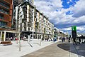
Precincts
The redevelopment project comprises three precincts: Barangaroo South, Barangaroo Central and Barangaroo Reserve.
Barangaroo South
-
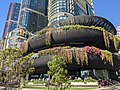 Barangaroo House
 -
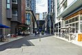 Mercantile Walk
 -
 Wulugul Walk
 -
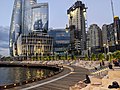 Watermans Cove


Barangaroo Central
Barangaroo Central will contain low-rise residential and commercial buildings.
With our harbour and climate, Sydney should be one of the world's best destinations, but we are being let down by an under-investment in quality tourism infrastructure... A world-class landmark resort on Sydney Harbour can be the catalyst to help turn the city around, just as Crown assisted in the turnaround of Melbourne... Some commentators have raised the process we are undertaking to progress our proposal. The NSW unsolicited proposal process exists to allow any organisation with unique ideas to make a submission to the government. We have followed that process to the letter and, despite reaching stage two, there is a long way to go... For a hotel resort in Sydney to be a landmark building that will attract millions of visitors, it must be on Sydney Harbour. Barangaroo is the only waterfront and harbourside location in the Sydney CBD that will accommodate such a development.
— James Packer in The Sydney Morning Herald, 3 November 2012
In July 2013 after a recommendation from an independent steering committee Premier O'Farrell announced the Crown proposal would be moved to Stage 3 of the unsolicited proposals process, the final stage where the parties will negotiate a binding contract.[47] The government is to receive an A$100 million upfront fee for the licence, despite being offered A$250 million with alternative tax arrangements which the steering committee's economic advisor Deloitte calculated was a superior offer.[48] Crown's intention is to lure Chinese high-rollers to its Sydney casino leveraging off its interests in its Macau casinos and taking advantage of a new streamlined visa process introduced by the Australian government for Chinese citizens wanting to gamble at Australian casinos.[49] In November 2013, it was announced that Crown Sydney received approval for the casino licence and place at Barangaroo.[50] Crown Sydney opened its resort hotel and restaurant/bars precinct in December 2020, though the casino is subject to future approval.[51]
Barangaroo Reserve
| Barangaroo Reserve | |
|---|---|
PWP Landscape Architecture | |
| Operated by | City of Sydney |
| Status | Open all year |

Barangaroo Reserve is a 6-hectare (15-acre) artificially recreated headland park at the northern end of Barangaroo. The park opened on 22 August 2015 and features a reconstructed, naturalistic headland based around the pre-1836 shoreline.

The Hawkesbury sandstone used to create Barangaroo Reserve was excavated on site. The foreshore of the park is constructed from 10,000 sandstone blocks excavated and cut on the site. Some 6,500 blocks were placed to create the foreshore. More than 42,000 tonnes (46,297 short tons) of rough stone and a further 30,000 tonnes (33,069 short tons) of crushed stone was also used in the construction. In addition, some 75,000 native trees, plants and shrubs have been used to landscape Barangaroo Reserve.
A total of 84 species were chosen, 79 of which are native to Sydney Harbour. Many of the species are not to be found in commercial nurseries, so seeds and cuttings were collected from wild sites around Sydney Harbour and the Hawkesbury River.[57]
A cultural facility called "the Cutaway", and car park is located beneath the headland.[58]
Population
According to 2016 census there were 189 people in Barangaroo. It was Sydney's most expensive area, with average apartments costing $10,000,000.[59] At the 2021 census the population had grown to 220.[60]
There has been criticism as the area was reclaimed for affordable housing, however features Australia's most expensive and exclusive real estate.
Transport
Ferry

Metro

Barangaroo railway station is a future rapid transit station servicing Barangaroo. It has been confirmed as part of the Sydney Metro City & Southwest project and is scheduled to open in 2024.[62]
The station will be served by automated six car
Bus
Barangaroo is served by Transdev John Holland bus routes 311, 324 and 325 to the Eastern Suburbs.[63]
Wynyard Walk
Wynyard Walk, connecting Wynyard station with Barangaroo, opened in 2016.[64][65][66][67]
See also
- Millers Point
Two other large-scale inner-city urban renewal projects in Sydney are:
References
- ^ Australian Bureau of Statistics (28 June 2022). "Barangaroo (suburb and locality)". Australian Census 2021 QuickStats. Retrieved 28 June 2022.
- ^ a b c d e f "Discover Barangaroo: History". Barangaroo, Sydney, Australia. Barangaroo Delivery Authority. 2011. Retrieved 23 January 2012.
- ^ Barangaroo Delivery Authority, Barangaroo.com.
- ^ "Barangaroo Timeline". Barangaroo Delivery Authority.
- ^ Pearlman, Jonathan (20 October 2006). "No kitsch within cooee of Barangaroo: contest winners". The Sydney Morning Herald. Retrieved 7 February 2012.
- ^ "Barangaroo". Geographical Names Register (GNR) of NSW. Geographical Names Board of New South Wales. Retrieved 23 January 2012.
- ^ "Barangaroo a north shore girl". Indigenous history of Sydney City. Sydney City Council. 19 October 2006. Archived from the original on 7 February 2012. Retrieved 23 January 2012.
- ^ a b Aston, Heath (19 October 2006). "It's Barangaroo, Darling". The Daily Telegraph. Australia. Retrieved 23 January 2012.
- ^ "Barangaroo, a Cameragal woman of courage" (PDF). Annual Report. Sydney: Barangaroo Delivery Authority. 2011. p. 12. Archived from the original (PDF) on 20 March 2012. Retrieved 23 January 2012.
- ^ Tench, Watkin (2006). "Chapter IX" (eBook). A Complete Account of the Settlement at Port Jackson. Adelaide: The University of Adelaide.
- ^ "A Bit of a Blog". Shirley Fitzgerald.
- ISBN 92-4-156110-6.
- ^ "agl history". agl.com.au.
- ^ "Argyle Cut". nga.gov.au.
- ^ "Saving the Workers' Flats - MILLERS POINT". millerspointcommunity.com.au. Archived from the original on 9 March 2015.
- ^ "Sydney's Hungry Mile made official". The Sydney Morning Herald. AAP. 29 July 2009. Retrieved 23 January 2012.
- ^ "Archived copy" (PDF). Archived from the original (PDF) on 21 October 2011. Retrieved 9 February 2012.
{{cite web}}: CS1 maint: archived copy as title (link) - ^ O'Nill, Steve (1997–1998). "Outline of Waterfront Dispute". Current Issues Brief (Parliamentary Library) (15). Retrieved 28 November 2013.
- ^ a b "History of the Barangaroo redevelopment". About us. Barangaroo Action Group. Archived from the original on 8 September 2011. Retrieved 23 January 2012.
- ^ Sartor, Frank (18 October 2006). "New look, new name for Sydney foreshore precinct" (Press release). Sydney: Department of Planning. Archived from the original on 16 May 2012. Retrieved 23 January 2012.
- ^ Pearlman, Jonathan (19 October 2006). "Barangaroo back in Sydney". The Sydney Morning Herald. Retrieved 23 January 2012.
- ^ "Opening Mass underway". The Sydney Morning Herald. AAP. 15 July 2008. Retrieved 23 January 2012.
- ^ "Barangaroo : Agency information guide July 2013" (PDF). Barangaroo Delivery Authority. Archived from the original (PDF) on 10 September 2015. Retrieved 5 December 2013.
- ^ "The Act" (PDF). Annual Report. Sydney: Barangaroo Delivery Authority. 2011. p. 5. Archived from the original (PDF) on 20 March 2012. Retrieved 23 January 2012.
- ^ "Clover Moore hits back at former PM quitting Barangaroo panel". Inner West Courier. 14 May 2011. Retrieved 23 January 2012.
- ^ Dempster, Quentin (1 March 2010). "Interview with Paul Keating" (transcript). Stateline. Sydney, Australia. Retrieved 23 January 2012.
- ^ Norrie, Justin (2 November 2006). "A monster so hungry it will eat all the sunlight". The Sydney Morning Herald. Retrieved 20 January 2012.
- ^ Moore, Matthew (4 March 2010). "Barangaroo towers breach height limits, says design architect". The Sydney Morning Herald. Retrieved 23 January 2012.
- ^ Moore, Matthew (22 September 2010). "Moore quits over Barangaroo 'railroading'". The Sydney Morning Herald. Retrieved 23 January 2012.
- ^ Moore, Matthew (11 August 2011). "Barangaroo review suggests a conflict of duty on design panel". The Sydney Morning Herald. Retrieved 23 January 2012.
- ^ Munro, Kesley (20 January 2012). "Top marks for Barangaroo clean-up – now to agree on a spot for hotel". The Sydney Morning Herald. Retrieved 23 January 2012.
- ^ "Welcome to Barangaroo South". Barangaroo Delivery Authority. Retrieved 23 January 2012.
- ^ "Commercial Buildings". Barangaroo South Designs. Lendlease. Retrieved 21 January 2012.
- ^ "Barangaroo". City of Sydney. Retrieved 23 January 2012.
- ^ "Premier pleased with new Sydney casino plans". ABC News. Australia. 27 February 2012. Retrieved 13 March 2012.
- ^ Chancellor, Jonathan (27 February 2012). "Barry O'Farrell endorses Packer Barangaroo casino concept". Property Observer. Retrieved 13 March 2012.
- ^ "Moore takes on O'Farrell over Barangaroo casino". ABC News. Australia. 28 February 2012. Retrieved 13 March 2012.
- ^ Moore, Matthew (28 February 2012). "Not so fast with that Dubai-style tower, says mayor". The Sydney Morning Herald. Retrieved 13 March 2012.
- ^ Kitney, Damon (29 February 2012). "Keep off the grass: Keating to Packer on Barangaroo casino". The Australian.
- ^ Prince, Madeline (29 February 2012). "A former PM, government architect and Sydney mayor challenge Packer's Barangaroo casino plans". Architecture Design.
- ^ Nicholls, Sean (25 October 2012). "Packer's $1b casino plan gets cabinet backing". The Sydney Morning Herald. Retrieved 4 November 2012.
- ^ Durie, John (26 October 2012). "Packer's Barangaroo casino plan should not be accepted at face value". The Australian. Retrieved 4 November 2012.
- ^ Kehoe, John (30 October 2012). "Ex-watchdog slams O'Farrell on Packer casino". The Australian Financial Review. Retrieved 4 November 2012.
- ^ Nicholls, Sean (2 November 2012). "Casino got nod faster than major tunnel plan". The Sydney Morning Herald. Retrieved 4 November 2012.
- ^ "Critics slam approval process for Packer casino". The world Today. Australia: ABC News. 26 October 2012. Retrieved 4 November 2012.
- ^ Packer, James (3 November 2012). "For the good of Sydney, back this plan". The Sydney Morning Herald. Retrieved 4 November 2012.
- ^ "Crown proposal moves to stage 3" (PDF). Premier of New South Wales. Archived from the original (PDF) on 24 April 2018. Retrieved 4 July 2013.
- ^ "O'Farrell under pressure to lay bare casino decision a day after receiving report". Sydney Morning Herald. Retrieved 31 July 2013.
- ^ "James Packer bets big on luring Chinese gamblers to Sydney". South China Morning Post. 28 July 2013. Retrieved 29 July 2013.
- ^ Nicholls, Sean (11 November 2013). "NSW gives green light to Packer casino at Barangaroo". Sydney Morning Herald. Retrieved 20 December 2014.
- ^ "Barangaroo – Sydney City". Destination New South Wales. Retrieved 14 March 2016.
- ^ McNally, Lucy; & staff (22 August 2015). "Barangaroo Reserve opens in Sydney; Paul Keating hails site's importance to local Indigenous history". ABC Online. Australian Broadcasting Corporation. Retrieved 22 August 2015.
- ^ a b "Barangaroo Point". Discover Barangaroo. Barangaroo Delivery Authority. 2013. Retrieved 21 January 2012.
- ^ "Barangaroo". Projects. PWP Landscape Architecture. 2014. Retrieved 21 December 2014.
- ^ "Millers Point survives - MILLERS POINT". millerspointcommunity.com.au. Archived from the original on 29 September 2015.
- ^ "Proposed Barangaroo names - MILLERS POINT". millerspointcommunity.com.au. Archived from the original on 11 March 2015.
- ^ FAQ Barangaroo.sydney Retrieved 28 August 2015
- ^ Moore, Matthew (10 September 2011). "Culture to bloom in Barangaroo bunker". The Sydney Morning Herald. Retrieved 23 January 2012.
- ^ Australian Bureau of Statistics (27 June 2017). "Barangaroo (State Suburb)". 2016 Census QuickStats. Retrieved 2 July 2017.
- ^ "2021 Barangaroo, Census All persons QuickStats". Australian Bureau of Statistics. Retrieved 18 August 2022.
- ^ O'Sullivan, Matt (26 June 2017). "Sydney's new ferry hub at Barangaroo opens to commuters". The Sydney Morning Herald. Fairfax Media. Archived from the original on 27 June 2017. Retrieved 27 June 2017.
- ^ Budget delivers $9 billion for public transport services and infrastructure Archived 26 June 2015 at the Wayback Machine Transport for NSW 23 June 2015
- ^ "New bus services set to roll into Barangaroo and Walsh Bay". Transport for NSW. 17 July 2015. Archived from the original on 20 July 2015. Retrieved 20 July 2015.
- ^ Early works to commence on Wynyard Walk Archived 16 December 2014 at the Wayback Machine Transport for NSW, 18 April 2012.
- ^ Wynyard walk tunnelling starts as Barangaroo wharf early works begin Archived 19 October 2014 at the Wayback Machine Transport for NSW 8 October 2014.
- ^ Wynyard Walk Transport for NSW, 12 November 2014
- ^ Wynyard Walk – Environment Archived 16 December 2014 at the Wayback Machine Transport for NSW, 9 December 2014.
33°51′40″S 151°12′11″E / 33.8611°S 151.203°E