
Bassas da India
You can help expand this article with text translated from the corresponding article in French. (February 2017) Click [show] for important translation instructions.
|
Bassas da India | |
|---|---|
 Flag | |
| Motto: Liberté, égalité, fraternité | |
| Anthem: "La Marseillaise" |
| Disputed island | |
|---|---|
 Map of the Scattered Islands in the Indian Ocean | |
| Geography | |
| Location | Mozambique Channel |
| Coordinates | 21°29′S 39°41′E / 21.483°S 39.683°E |
| Administration | |
| Overseas territory | French Southern and Antarctic Lands |
| District | Scattered Islands in the Indian Ocean |
| Claimed by | |
Bassas da India (French pronunciation:
The atoll consists of ten barren rocky islets, with no vegetation, totaling 20 hectares (49 acres) in area. Those on the north and east sides are 2.1 to 3.0 metres (7 to 10 ft) high, while those on the west and south sides are 1.2 metres (4 ft) high. The reef, whose coastline measures 35.2 km (21.9 mi), is entirely covered by the sea from three hours before high tide to three hours afterward. The region is also subject to cyclones, making the atoll a long-time maritime hazard and the site of numerous shipwrecks.
Jaguar Seamount and Hall Tablemount lie, respectively, about 40 and 70 kilometres (25 and 43 mi) further southwest.
History
The Bassas da India was first recorded by
It was rediscovered by the Europa in 1774, whence the name "Europa Rocks".[4] The Malay was lost 27 July 1842 on the Europa Rocks.[5]
In 1897, the shoal became a
Wildlife
The presence of Galapagos sharks was reported in 2003, which is a first in the Mozambique Channel.[6]
Tourism
Gallery
-
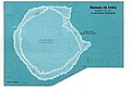
 Detailed map.
 -
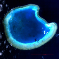
 International Space Station (ISS) photograph.
 -
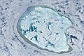
 Landsat 7 image.
 -
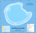
 CIA World Factbook map.
 -
-
 ISS image of Bassas da India with varying degrees of sunglint.


References
- ^ "Décret n° 78-146 du 3 février 1978 portant création, en application de la loi du 16 juillet 1976, d'une zone économique au large des côtes des îles Tromelin, Glorieuses, Juan-de-Nova, Europa et Bassas-da-India". Decree No. 78-146 of 3 February 1978 (in French). Government of France.
- ^ Cardozo, Manoel Godinho (1736) [First published 1602]. "Relaçam do navfragio da nao Santiago & itenerario da gente que delle se salvou". In Gomes de Brito, Bernardo (ed.). História trágico-marítima (in Portuguese). Vol. II. Lisbon: Off. da Congregaçao do Oratorio. p. 47.
- ISSN 1015-0935.
- OCLC 36761841.
Bassas da India, sometimes named Europa rocks, was discovered by the ship Europa in 1774.
- OCLC 248257682.
- ^ Hammerschlag, Neil; Fallows, Chris. "Galapagos sharks (Carcharhinus galapagensis) at the Bassas da India atoll: first record from the Mozambique Channel and significance can have a nursery area". South African Journal of Science. 101: 375–377.
- ^ "Accès et mouillage dans les Eparses" [Access and mooring in the Scattered Islands]. TAAF : Terres australes et antarctiques françaises (in French). Government of France. Retrieved 3 February 2020.
- ^ "Loi n° 83-582 du 5 juillet 1983 relative au régime de la saisie et complétant la liste des agents habilités à constater les infractions dans le domaine des pêches maritimes". Act No. 83-582 of 5 July 1983 (in French). Government of France.
- French Ministry of Defense. 13 November 2013.
- ^ "Pêche non autorisée : le Floréal intercepte un bateau au large de Bassas da India" [Unauthorized fishing : the Floréal intercepts a boat off Bassas da India] (in French). Imaz Press Réunion. 9 October 2014.
Further reading
- Warne, Kennedy (April 2014). "A tale of two atolls". National Geographic. pp. 62–75.
External links
 Wikimedia Atlas of Bassas da India
- "Oceandots". Archived from the original on 23 December 2010. Retrieved 2009-03-14.
- Sailing Directions: East Africa and the South Indian Ocean
- French Southern and Antarctic Lands. The World Factbook. Central Intelligence Agency..