Bastrop County Complex Fire
| Bastrop County Complex fire Part of the power lines | |
|---|---|
| Map | |
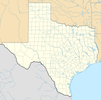
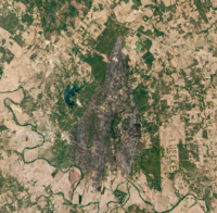
 Perimeter of Bastrop County Complex Fire (map data) | |
The Bastrop County Complex fire was a
Two people were killed by the wildfire, and another twelve people were injured. The fire perimeter encircled an area spanning at least 32,000 acres (12,950 hectares). Homes were destroyed in ten subdivisions, of which Circle-D County Acres and Tahitian Village sustained the most significant property damage. The wildfire destroyed more homes than any single fire in Texas history by nearly a factor of ten. Around 96 percent of Bastrop State Park was scorched by the wildfire. Roughly 1.5 million trees across 16,200 acres (6,600 hectares) of forest were either killed directly by the fire or fatally damaged. Despite the severe
Setting and environmental conditions

The Bastrop County complex occurred within the
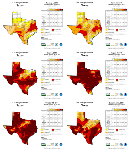

Dry conditions perpetuated by the drought led to widespread die-offs of trees across central and eastern Texas by the early fall of 2011, and most forests throughout the state were exceptionally dry;[7] 251 of the 254 counties in Texas had bans on outdoor burning in effect in September 2011.[3] The moisture content of all vegetation types within Bastrop County diminished to record lows during the course of the drought, making them increasingly susceptible to combustion.[2] According to the U.S. Drought Monitor,[a] the entirety of Bastrop County had remained in exceptional drought – the most severe drought conditions – since the week of May 10, 2011, and had been experiencing at least abnormally dry conditions since at least the week of October 26, 2010.[11] Numerous wildfires occurred across Texas and adjoining states in 2011; more land area was burned in Texas and Oklahoma since official recordkeeping began in 2002.[5] Between November 2010 and September 2011, Texas wildfires engulfed over 3.7 million acres (1.5 million hectares) of land; within the first week of September 2011, 135,000 acres (54,600 hectares) burned.[3]
Amid the exceptional drought in early September 2011,
Fire progression
The wildfire complex began as three individual fires whose ignitions were reported within three hours on September 4, 2011.
The third individual fire was ignited by a tree contacting a power line south of the highway near Tahitian Drive at 5:16 p.m. and eventually merged with the larger fire;
The passage of a cold front ushered in a decrease in temperatures on September 5. The movement of Tropical Storm Lee east away from Texas slackened winds, though gusts remained in the 20–25 mph (32–40 km/h) range. The combination of gusts with continued low relative humidity and strong atmospheric instability perpetuated environmental conditions conducive to large fire growth.[3] The Bastrop County Complex remained 0 percent contained heading into the afternoon of September 5,[20] with its advance still unperturbed by firefighting efforts.[21] Flames reached the Colorado River and crossed south of the river twice during the day, hamstringing the ability for firefighters to obtain water.[22][23] State officials stated on September 5 that the Bastrop County Complex had destroyed 476 homes, setting a record for the most homes destroyed by a single wildfire in Texas. The fire had engulfed over 25,000 acres (10,000 hectares) but its spread north of the Colorado River had slowed. Over 250 firefighters were working on containing the fire's spread, aided by bulldozers to create firebreaks and TFS air tankers.[24]
The conflagration remained completely uncontained on September 6. The TFS released a statement that day describing the fire's behavior as "unprecedented" and that "no one on the face of this Earth has ever fought fires in these extreme conditions."[25][26] Considerable progress in containing the fire was made on September 7, with fire containment reaching 30 percent and no additional structures being destroyed. The outward advance of the wildfire was mostly stopped, but burning continued within the preexisting burn area.[27] The TFS assessed that 785 homes had been destroyed by September 7,[28] but the enumeration of the number of destroyed homes increased significantly the following day to 1,386 based on surveys conducted by Bastrop County officials.[29] The wildfire was 50 percent contained by noon on September 10 and 70 percent contained by noon on September 12.[30] Dry weather had remained in place over the Bastrop area for nearly two weeks after the wildfire first ignited, but light rain and humid conditions prevailed for the first time on September 17, attenuating flare-ups within the burn area; at the time, the fire was 85 percent contained.[31] After September 22, 18 days after ignition, the wildfire was 95 percent contained.[32] Beneficial rains on September 24–25, including totals as much as 2 in (51 mm) in parts of Bastrop County, allowed firefighters to target hot spots more deeply embedded within the fire perimeter.[33]
The wildfire spread past a firebreak on October 4 towards the northern portions of the previous burn scar, burning 309 acres (125 hectares) of land including parts of Griffith League Ranch. This extension of the Bastrop County Complex was called the Old Potato Road fire and was fully contained on October 10.[32][34] The Bastrop County Complex was declared controlled on October 10.[4] However, flare-ups within the burn area continued until October 29, when the fire was completely extinguished. In total, the wildfire lasted for 55 days.[35]
Another fire, called the Union Chapel Fire, began on the afternoon of September 5 near Cedar Creek High School some 18 mi (29 km) to the west of the Bastrop County Complex.[36][37] Though a discrete fire, TFS operations considered the Union Chapel Fire a part of the Bastrop County Complex.[38][39] The fire consumed 912 acres (369 hectares) and destroyed 25 homes and 2 businesses, prompting the evacuation of 200 people, but was 90 percent contained by September 8.[40][41][42][3]
Firefighting efforts

More than 30 airplanes and helicopters from the
Closures and evacuations
The first evacuations of homes began within 20 minutes of the first fire being reported on September 4.[16] The evacuation of Bastrop State Park was ordered at 3:16 p.m. CDT on September 4, while evacuation of neighborhoods south of Texas State Highway 71 began at around 3:30 p.m. CDT that day, less than an hour before the fire crossed the highway.[14] Buescher State Park was also closed on September 4 but reopened on September 20 without the fire entering the extent of the park.[50][51] Twenty subdivisions were subject to evacuations during the spread of the fire, including mandatory evacuation orders, accounting for some 5,000 people.[52][15][48] Some residents were allowed to examine the hardest-hit neighborhoods for the first time on September 8.[53] A staggered reentry of residents to additional evacuated subdivisions began on September 12 and continued through September 15 as the wildfire subsided.[54] Bastrop Middle School and the First Baptist Church in Smithville, Texas, were designated as shelters for wildfire evacuees.[55] Volunteers rescued 160 animals from the Bastrop Animal Shelter, evacuating them to Austin.[56] Bastrop Independent School District and Smithville Independent School District closed their schools on September 6 and resumed classes on September 12;[57][58][59] the school closures also resulted in cancellations of football and volleyball events for area schools.[60] Bluebonnet Electric Cooperative relocated around 50 of its workers from its Bastrop headquarters to Giddings, Texas, on the night of September 4 to continue monitoring the electric grid.[61] Texas State Highway 71 was closed during the fire and reopened at 8:00 a.m. CDT on September 10.[62] Texas State Highway 21 was also closed but reopened on September 12.[54] The breach of the firebreak on October 4 prompted additional road closures and the evacuations of 25–30 homes.[63]
Impact and effects
The conflagration consumed at least 32,000 acres (12,950 hectares) of land, burning across subdivisions within the wildland–urban interface, unmanaged private land, and much of Bastrop State Park.[2] Two people were killed and twelve people were injured.[15] The fire destroyed 1,660 homes and 36 businesses, accounting for approximately 59.4 percent of the structures caught within the wildfire's burn perimeter.[15][3] Most of the destroyed structures were burned by the wildfire within the first three days of ignition.[3] In some cases, homes burned so intensely that their foundations ruptured.[64] Another 1,091 homes were saved by firefighting efforts. Homes were destroyed in ten subdivisions, with the greatest losses occurring in Circle-D County Acres and Tahitian Village subdivisions. Structures were destroyed in five incorporated and unincorporated communities: Bastrop, Cedar Creek, McDade, Paige, and Smithville. A majority of the structures destroyed were in the Bastrop area.[3] Based on the number of homes destroyed, the Bastrop County Complex was the most destructive in Texas history and third most destructive in U.S. history; however, accounting for fires for which official enumerations of damage do not exist, the fire may have been the sixth most destructive in U.S. history.[7] The previous record for the most homes destroyed by a single fire in Texas was 168, set by the Possum Kingdom Fire in April 2011.[3] The Insurance Council of Texas estimated that the fire inflicted $325 million in insured losses, making the Bastrop County Complex the costliest wildfire in Texas history and among the costliest in U.S. history.[65][66] The estimated toll exceeded the estimated losses statewide from fires in 2009 – the costliest year for wildfires in the state before 2011.[65][67] Accounting for the populations of counties in which destructive wildfires have occurred, the Bastrop County complex may have at the time been the costliest conflagration per capita in the wildland–urban interface in U.S. history based on an estimated loss of $209.3 million as estimated by the Bastrop Tax Appraisal District.[3] Power outages caused or prompted by the fire affected 3,800 homes;[68] all power was restored by September 27.[69]
The two people killed by the fire were found on September 6, 2011, after law enforcement and search crews combed through burned neighborhoods.[70][71] One person was found near Smithville and the other near Paige; both of the fatalities were in neighborhoods that had been evacuated.[72][73] Urban Search and Rescue Texas Task Force 1 was later deployed to the area to search for additional victims.[74]
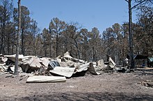
The Bastrop County Complex affected 96 percent of Bastrop State Park,
The fire also spread across 39 percent of the Lost Pines
Approximately 1.5 million trees were either killed by the fire or assessed by the TFS as being "alive but likely to die soon". More than 16,200 acres (6,600 hectares) of forest burned in the wildfire, and over 24 million ft3 (680,000 m3) of timber was either destroyed or irreparably damaged, representing 78 percent of trees in the areas affected by the fire.[83] The fire burned unevenly, leaving some areas lightly scorched while burning other areas so thoroughly that all nutrients were purged from the underlying soil.[2] The strong winds that sparked the fire carried ashes and embers to great distances. Softball-sized aggregations of charred pine trees were found in Rosanky, Texas, 15 mi (24 km) south of the Colorado River.[14]
Reaction
Political response
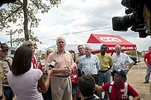
In response to the wildfire,
On September 7, 2011, President Barack Obama personally telephoned Perry to discuss the fires. That same day, the White House issued a formal statement, saying that "Over the last several days, at the request of the Governor, the Administration has granted eight Fire Management Assistance Grants, making federal funds available to reimburse eligible costs associated with efforts to combat the fires. FEMA is actively working with state and local officials to conduct damage assessments and to identify areas where additional federal assistance may be warranted."[88]
Community and social media efforts
Members of the community were noted for voluntarily working to save several homes from destruction by the wildfire.
On September 27, 2011, the Bastrop County Long Term Recovery Team (BCLTRT) was formed as a volunteer organization of community members, eventually becoming a
In the aftermath of the wildfire, students at Texas A&M University formed Aggie Wildfire Relief to raise funds for wildfire recovery. The organization started a "Wear White, Wave Maroon" campaign for a home football game against Baylor University on October 15, 2011, raising over $16,000 from the sales of white T-shirts and maroon towels for donations towards the American Red Cross and the Texas Wildfire Relief Fund.[95][96][97]
Aftermath

On September 9, 2011, U.S. President
Vegetation in Bastrop State Park began to regrow after the fire. Recovery efforts were costly, with erosion control costing at least three times the park's annual budget and lolloby pine replanting costing at least seven times the park's annual budget. The park partially reopened on December 2, 2011, but closed again the next month following heavy rainfall. After additional park rehabilitation projects were completed, most hiking trails, camping areas, and cabins in the park reopened to the public.[104][76]
Several lawsuits were filed against private companies concerning the inadequate pruning of trees near power lines. A
See also
- Hidden Pines Fire – wildfire in Bastrop County in 2015
- Camp Fire (2018) – destructive wildland–urban interface fire in California
Notes
- U.S. Department of Agriculture, and the National Oceanic and Atmospheric Administration and documents the spatial extent and severity of drought conditions in the U.S.[10]
- ^ Within the Incident Command System, types describe the complexity and breadth of the response to incidents, including wildfires. A Type 1 response indicates the use of national resources for major incidents. A Type 3 response is utilized for extended fire suppression efforts and implies a more localized response.[33][49]
References
- ^ "Bastrop Fire". InciWeb. National Wildfire Coordinating Group. October 15, 2011. Archived from the original on October 15, 2011. Retrieved January 6, 2023.
- ^ a b c d e f g h i j k l Rissel, Sean; Ridenour, Karen (April 2013). "Ember Production During the Bastrop Complex Fire" (PDF). Fire Management Today. 72 (4). Washington, D. C.: United States Forest Service: 7–13. Retrieved January 6, 2013.
- ^ a b c d e f g h i j k l m n o p q r s t u v Ridenour, Karen; Rissel, Sean; Powell, Wade; Gray, Rich; Fisher, Mike; Sommerfeld, Julie (May 2012). Bastrop Complex Wildfire Case Study (PDF) (Report). Texas Forest Service. Retrieved January 5, 2023.
- ^ S2CID 128525375.
- ^ S2CID 90183810.
- ^ .
- ^ S2CID 132108194.
- ^ Forsyth, Jim (September 8, 2011). "Scorching Texas summer heat trumps Dust Bowl record". Reuters. Retrieved December 26, 2022.
- ^ "Texas sets record for hottest summer in US". NBC News. NBC Universal. September 8, 2011. Retrieved January 6, 2023.
- ^ "What is the USDM". U.S. Drought Monitor. National Drought Mitigation Center.
- ^ "Data Tables (Bastrop County, Texas)". U.S. Drought Monitor. National Drought Mitigation Center. Retrieved January 6, 2023.
- ^ Coppolo, Sarah (September 6, 2011). "In bitter twist, Lee partly to blame". Austin American-tatesman. Austin, Texas. p. A5. Retrieved January 5, 2023 – via Newspapers.com.
- ^ Garner, J. M. (September 4, 2011). "Storm Prediction Center Day 1 Fire Weather Outlook, 0243 AM CDT SUN SEP 04 2011". Norman, Oklahoma. Retrieved December 26, 2022.
- ^ a b c d e f g h i j k Harmon, Dave (October 3, 2012). "Unstoppable: anatomy of Texas' most destructive wildfire". Austin American-Statesman. Austin, Texas: Statesman.com. Retrieved December 31, 2022.
- ^ a b c d "Community Development & Revitalization: 2011 Wildfires" (PDF). Texas General Land Office. Retrieved January 5, 2023.
- ^ a b c d Texas Forest Service Fire Investigation Report (PDF) (Report). Texas Forest Service. Retrieved December 31, 2022.
- ^ George, Patric (September 21, 2011). "Bastrop fire's apparent cause: trees hitting power lines". Austin American-Statesman. Austin, Texas: Statesman.com. Retrieved January 4, 2023.
- ^ "State: Power line sparks likely caused Texas blaze". The San Diego Union-Tribune. Associated Press. September 20, 2011. Retrieved January 13, 2023.
- ^ George, Patrick; Ball, Andrea; Taboada, Melissa (September 5, 2011). "'Most catastrophic day' of fires in area". Austin American-Statesman. Austin, Texas. p. A1. Retrieved January 4, 2023 – via Newspapers.com.
- ^ O'Rourke, Ciara (September 6, 2011). "In Bastrop, residents look for answers". Austin American-Statesman. Austin, Texas. p. A7. Retrieved January 5, 2023 – via Newspapers.com.
- ^ "Wildfire update – Sept. 5, 2011". Texas Forest Service. September 5, 2011. Archived from the original on September 8, 2011. Retrieved September 8, 2011.
- ^ Hennessy-Fiske, Molly (September 6, 2011). "Texas wildfires destroy at least 500 homes". Los Angeles Times. Los Angeles, California. Retrieved January 5, 2023.
- ^ McDonald, Colin (September 5, 2011). "More than 600 homes destroyed in Bastrop area". Chron. Houston, Texas: Hearst. Retrieved January 5, 2023.
- ^ Brooks, Karen (September 5, 2011). "Austin-area wildfire burns a record 476 homes in Texas". Reuters. Retrieved January 4, 2023.
- ^ Hudson, John (September 6, 2011). "'No Containment' Yet of Raging Texas Wildfire". The Atlantic. The Atlantic Monthly Group. Retrieved January 9, 2023.
- ^ ""No containment" of Texas wildfire". The Early Show. CBS News. September 6, 2011. Retrieved January 9, 2023.
- ^ a b Mondo, Michelle (September 7, 2011). "Firefighters gain ground against Bastrop blaze". Chron. Houston, Texas: Hearst. Retrieved January 5, 2023.
- ^ "Wildfire update – Sept. 7, 2011". Texas Forest Service. September 7, 2011. Archived from the original on September 8, 2011. Retrieved September 8, 2011.
- ^ Brooks, Karen (September 8, 2011). "Officials triple number of homes charred in Texas fire". Reuters. Retrieved January 13, 2023.
- ^ "Bastrop County Fire Complex Fact Sheet: Saturday, September 10, 2011 - 12:00 PM" (PDF). Bastrop, Texas: Government of Bastrop County. September 10, 2011. Retrieved January 6, 2023.
- ^ O'Rourke, Ciara (September 17, 2011). "Damp weather some help in corralling Bastrop fire". Austin American-Statesman. Statesman.com. Archived from the original on September 23, 2011. Retrieved January 13, 2023.
- ^ S2CID 91148055.
- ^ a b c Mashood, Farzad (September 24, 2011). "With Bastrop fire 95 percent contained, recovery is new focus for fire crews". Austin American-Statesman. Austin, Texas: Statesman.com. Archived from the original on September 24, 2011. Retrieved September 24, 2011.
- ^ "Old Potato Rd. fire fully contained, Bastrop to discuss recovery plan". KVUE. Austin, Texas: KVUE-TV. October 10, 2011. Retrieved January 6, 2023.
- ^ a b "Life After Wildfire". Bastrop State Park. Austin, Texas: Texas Parks & Wildlife. Retrieved December 26, 2022.
- ^ Plohetski, Tony; George, Patrick (September 6, 2011). "Fires: Many areas remain closed to residents". Austin American-Statesman. Austin, Texas. p. A6. Retrieved January 5, 2023 – via Newspapers.com.
- ^ "Suspected teen arsonists sought as other wildfires rage in Texas". CNN. CNN.com. September 8, 2011. Retrieved January 5, 2023.
- ^ Heinz, Frank (August 15, 2012). "Texas Wildfire Update: Friday". NBC 5 Dallas-Fort Worth. Fort Worth, Texas: NBCUniversal Media. Retrieved January 5, 2023.
- ^ "9/10/11 Fire Update". KLTV. Tyler, Texas: Gray Television. September 10, 2011. Retrieved January 5, 2023.
- ^ Bernier, Nathan; Chavez, Crystal (September 8, 2011). "Central Texas Wildfire Updates September 8, 2011". KUT. Austin, Texas: KUT Public Media. Retrieved January 5, 2023.
- ^ Mondo, Michelle (September 8, 2011). "Bastrop blaze destroys more than 34,000 acres". Chron. Houston, Texas: Hearst. Retrieved January 5, 2023.
- ^ Bernier, Nathan; Chavez, Crystal (September 6, 2011). "Central Texas Wildfire Updates September 6, 2011". KUT. Austin, Texas: KUT Public Media. Retrieved January 5, 2023.
- ^ a b Kreytak, Steven (September 7, 2011). "2 Dead In Bastrop Fires". Austin American-Statesman. Austin, Texas. pp. A1, A8. Retrieved January 17, 2023 – via Newspapers.com.
- ^ "DC-10 to drop retardant starting Friday". KXAN. LIN Television of Texas. September 7, 2011. Archived from the original on January 28, 2013. Retrieved January 13, 2023.
- ^ Eaton, Tim (September 12, 2011). "Fleet of firefighting aircraft to be stationed in Austin". Austin American–Statesman. Austin, Texas: Statesman.com. Archived from the original on January 20, 2012. Retrieved January 13, 2023.
- ^ "Firefighting plane's use in Texas wildfire delayed". Victoria Advocate. Victoria, Texas: VictoriaAdvocate.com. September 8, 2011. Retrieved January 13, 2023.
- ^ Eaton, Tim (September 13, 2011). "Firefighting planes will remained housed at Austin airport". Austin American-Statesman. Austin, Texas. p. A8. Retrieved January 17, 2023 – via Newspapers.com.
- ^ a b "Bastrop fire still uncontained, and it may get worse". The Gonzales Cannon. Gonzales, Texas. September 4, 2011. Archived from the original on January 3, 2013. Retrieved January 13, 2023.
- ^ "Wildland Fire: Incident Command System Levels". National Park Service. February 13, 2017. Retrieved January 13, 2023.
- ^ McCorkle, Rob (September 22, 2011). "'Lost Pines' Experience Lives on at Buescher State Park". Texas Parks & Wildlife. Texas Parks and Wildlife Department. Retrieved January 17, 2023.
- ^ "Bastrop and Buescher State Parks: Interpretive Guide" (PDF). Texas Parks and Wildlife Department. 2019. Retrieved January 17, 2023.
- ^ Mondo, Michelle (September 8, 2011). "Bastrop blaze destroys more than 34,000 acres". Chron. Houston, Texas: Hearst. Retrieved January 5, 2023.
- ^ Ball, Andrea; Eaton, Tim; Ward, Mike (September 9, 2011). "Residents return to 'war zone'". Austin American-Statesman. Austin, Texas. pp. A1, A6. Retrieved January 17, 2023 – via Newspapers.com.
- ^ a b "Bastrop County Fire Complex Fact Sheet: Saturday, September 12, 2011 - 12:00 PM" (PDF). Bastrop, Texas: Government of Bastrop County. September 12, 2011. Retrieved January 6, 2023.
- ^ a b Stayton, Jennifer; Crawford, Ian (September 4, 2011). "Bastrop Fire Forces Hundreds to Evacuate". KUT. Austin, Texas: KUT Public Media. Retrieved January 5, 2023.
- ^ "160 animals saved from Bastrop shelter". KXAN. LIN Television of Texas. September 8, 2011 [September 5, 2011]. Archived from the original on November 12, 2011. Retrieved February 8, 2013.
- ^ Bernier, Nathan (September 5, 2011). "Wildfires To Close Some Schools Tuesday". KUT. Austin, Texas. Retrieved January 5, 2023.
- ^ Weissert, Will (August 15, 2012) [September 12, 2011]. "Bastrop ISD Kids Return to School". NBC 5 Dallas-Fort Worth. Fort Worth, Texas: NBCUniversal Media. Retrieved January 5, 2023.
- ^ Chavez, Crystal (September 12, 2011). "Top Morning Stories September 12, 2011". KUT. Austin, Texas: KUT Public Media. Retrieved January 5, 2023.
- ^ Cantu, Rick; Weber, Andrew (September 7, 2011). "Football, volleyball games cancelled". Austin American-Statesman. Austin, Texas. Retrieved January 17, 2023 – via Newspapers.com.
- ^ "Electric cooperative headquarters relocated". Austin American-Statesman. Austin, Texas. September 7, 2011. p. A8. Retrieved January 17, 2023 – via Newspapers.com.
- ^ "Major Disaster Declaration Issued — Progress Continues" (PDF) (Press release). Texas Forest Service. September 10, 2011. Retrieved January 6, 2023 – via Government of Bastrop County.
- ^ "Old Potato Road Fire" (PDF). Bastrop, Texas: Government of Bastrop County. October 4, 2011. Retrieved January 6, 2023.
- ^ "Bastrop Wildfire Losses Rise" (PDF). Insurance Council of Texas. December 8, 2011. Archived from the original (PDF) on April 24, 2012. Retrieved December 26, 2011.
- ^ a b "Losses from Bastrop, Texas, Wildfire Rise to $325M". Claims Journal. December 12, 2011. Retrieved January 4, 2023.
- ^ "Bastrop County Hazardous Fuels Reduction Project HMGP-FM-5233-TX Project #7" (PDF). FEMA. September 2021. Retrieved January 5, 2023.
- ^ "Hazard Profile". Hazard Mitigation Plan, Bastrop County (PDF) (Report). Bastrop,Texas: Bastrop County Office of Emergency Management. October 2016.
- ^ McDonald, Colin (September 5, 2011). "Fires destroy homes in Bastrop, Magnolia". Chron. Houston, Texas: Hearst. Retrieved January 5, 2023.
- ^ Vega, Jackie (September 27, 2011). "Bastrop Complex fire now 98% contained". KXAN. LIN Television of Texas. Archived from the original on September 30, 2011. Retrieved January 13, 2023.
- ^ "Wildfire update – Sept. 18, 2011". Texas Forest Service. September 18, 2011. Archived from the original on September 23, 2011. Retrieved September 23, 2011.
- ^ Bernier, Nathan (September 6, 2011). "Two People Killed In Bastrop Fire". KUT. Austin, Texas: KUT Public Media. Retrieved January 13, 2023.
- ^ "As battle continues, Texas wildfire victim identified". Los Angeles Times. Los Angeles. September 10, 2011. Retrieved January 13, 2023.
- ^ Ceasar, Stephen; Hennessy-Fiske, Molly (September 6, 2011). "Texas wildfire kills two people who refused evacuation orders". Los Angeles Times. Los Angeles. Retrieved January 13, 2023.
- ^ "Texas fires kill 4, destroy more than 1,000 homes". 9News. KUSA-TV. Associated Press. September 6, 2011. Retrieved January 13, 2023.
- ^ "Wildfires Consuming Bastrop State Park". Texas Parks and Wildlife. September 6, 2011. Retrieved January 13, 2023.
- ^ a b Harmon, Dave (December 12, 2018) [November 23, 2011]. "Fire-scarred Bastrop State Park reopening Dec. 2". Austin American-Statesman. Austin, Texas: Statesman.com. Retrieved January 17, 2023.
- ^ a b Wear, Ben (September 7, 2011). "Pines hit hard; toad habitat ravaged". Austin American-Statesman. Austin, Texas. Retrieved January 5, 2023 – via Newspapers.com.
- ^ "Wildfire & Flood Damage". Bastrop State Park. Austin, Texas: Texas Parks & Wildlife. Retrieved January 5, 2023.
- ^ Lowe, John; McNatt, Logan; Howard, Margaret; Gibbs, Joshua (October 2019). "Archeological Surveys in Response to the Bastrop County Complex Fire, Bastrop State Park, Bastrop County, Texas" (PDF). Austin, Texas: Texas Parks and Wildlife Department. Retrieved January 13, 2023 – via University of North Texas.
- ^ S2CID 181586929.
- .
- ^ Forstner, Michael R.J.; Dixon, Jay; Stout, David (July 11, 2012). "Houston toad 2011-2012 chorusing and habitat evaluation" (PDF). Colovista Sand and Gravel Mining. Archived from the original (PDF) on January 17, 2023. Retrieved January 17, 2023.
- ^ "Trees Damaged and Destroyed in the Bastrop Fire" (PDF). Texas Forest Service. September 28, 2011. Retrieved January 4, 2023.
- ^ Dolak, Kevin; Ben Forer (September 6, 2011). "Texas Wildfires: Perry Returns as Dozens of Blazes Rage". ABC News. Retrieved September 6, 2011.
Texas Gov. Rick Perry set aside his campaign for the Republican presidential nomination to focus attention on the troubles on the emergency at home. He cut short a campaign stop in South Carolina to return to Texas Monday.
- ^ McDonald, Colin; Jessica Kwong (September 6, 2011). "Uncontrolled Central Texas wildfires pushed by wind". San Antonio Express News. Retrieved September 6, 2011.
- ^ Hicks, Nolan (September 6, 2011). "The politics of a firestorm". Houston Chronicle. Retrieved September 6, 2011.
- ^ a b Graves, Lucia; Jason Cherkis (September 7, 2011). "Rick Perry's Budget Leaves Texans In Bind Amidst Historic Wildfires". Huffington Post. Retrieved September 8, 2011.
- ^ Gottlieb, Benjamin (September 7, 2011). "Obama Reaffirms Federal Assistance For Texas Fires". Neon Tommy. USC Annenberg School for Communication and Journalism. Archived from the original on April 1, 2012. Retrieved September 8, 2011.
- ^ Mortensen, Michelle (September 8, 2011). "Bastrop's spirit glows brighter in fire". KXAN. Archived from the original on January 27, 2013. Retrieved September 9, 2011.
- ^ Bergamo, Jim (September 8, 2011). "Social media helps recovery efforts in Bastrop". KVUE. Retrieved September 9, 2011.
- ^ Mongillo, Peter (September 22, 2011). "Banding together for Bastrop neighbors". Austin American-Statesman. Austin, Texas. pp. B1, B3. Retrieved January 17, 2023 – via Newspapers.com.
- ^ Mongillo, Peter (October 18, 2011). "Thousands attend wildfire benefit concert". Austin American-Statesman. Austin, Texas. pp. B1, B3. Retrieved January 17, 2023 – via Newspapers.com.
- ^ Currie, Kristen (September 10, 2021). "Bastrop County recovery group still working 10 years after devastating fire". KXAN. Austin, Texas: Nexstar Media. Retrieved January 17, 2023.
- ^ Files, Chris (August 16, 2012). "The Behind the Scenes Story of the Bastrop Fire Recovery". The Episcopal Diocese of Texas. Retrieved January 17, 2023.
- ^ Cannon, Stephanie (September 27, 2011). "Wear White, Wave Maroon". The Association of Former Students of Texas A&M University. Retrieved January 17, 2023.
- ^ Cannon, Stephanie (October 10, 2011). "Wear White, Wave Maroon". The Association of Former Students of Texas A&M University. Retrieved January 17, 2023.
- ^ Balke, Jeff (October 16, 2015). "Texas A&M; Students Rally in Support of Wildfire Relief with Towels". Houston Press. Houston, Texas. Archived from the original on October 19, 2021. Retrieved January 17, 2023.
- ^ "exas - Wildfires FEMA-4029-DR" (PDF). FEMA. September 9, 2011. Retrieved January 13, 2023.
- ^ Weissert, Will; Plushnick-Masti, Ramit (September 11, 2011). "Texas fire destroys 1,554 homes, 17 people missing". The Seattle Times. The Seattle Times Company. Associated Press. Archived from the original on January 14, 2012. Retrieved July 6, 2013.
- ^ Ward, Mike (September 7, 2011). "FEMA teams head to fire-ravaged areas to tally damage". Austin American-Statesman. Austin, Texas. p. A8. Retrieved January 17, 2023 – via Newspapers.com.
- ^ "Bastrop fire cleanup begins". News Channel 10. Gray Television. October 2, 2011. Retrieved January 13, 2023.
- ^ Bell, Jeff (February 13, 2020). "2011 Bastrop County wildfire: $5M settlement reached in case against tree company". KVUE. KVUE-TV. Retrieved December 31, 2022.
- ^ Sevilla, Andy (September 26, 2018) [August 7, 2018]. "Bastrop County, school districts sue for losses after Complex Fire". Austin American-Statesman. Austin, Texas. Retrieved August 7, 2023.
- ^ Whitney, Anna (April 20, 2012). "Bastrop State Park Emerges From Fire, With a Focus on Prevention". The Texas Tribune. Retrieved January 17, 2023.
- ^ Barer, David (April 6, 2016). "Devastating Bastrop Complex Fire sparks lawsuit". KXAN. Austin, Texas: Nexstar Media. Retrieved December 27, 2022.
- ^ Mulder, Brandon (February 14, 2020). "$5M settlment reached in 2011 Bastrop County wildfire". Austin American-Statesman. Austin, Texas. Retrieved December 28, 2022.
External links
- Footage of the fire as seen from Texas State Highway 21
- Footage of the firefront's advance along the northern edge of Bastrop State Park
- Boston Globe photos of Bastrop fire, including va iew from International Space Station
- The Fire: Inside the Bastrop County Complex Fire (2011) – documentary concerning the fire and its aftermath

