
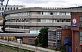
Baynard House, London


Baynard House is a
Features and uses
The building was designed by
"BAYNARD HOUSE handed over on 5th July 1979 to PETER BENTON Esq., Managing Director Telecommunications, Architects: Holford / PSA; Construction: John Laing"[5]
Legislation protecting the sightline of St Paul's Cathedral from bridges across the Thames and from places such as Putney and Richmond Park restricted the overall height of the building to three full levels above ground.[6]
Baynard House was for a few years a telephone exchange, and housed the first operational System X telephone exchange, which went live in 1980.[7][8] From 1982 to 1997 it housed the BT Museum.
It is the site of an unusual cast aluminium public sculpture by
As of 2012[update] it had the largest solar panel area in the City of London and the second largest of a corporate building in the UK.[11]
The Faraday Building, one of the first major telephone exchanges in the UK, is across the road.
In film
Actor Tom Cruise broke his ankle whilst performing a stunt, jumping from the roof in 2017, shooting scenes for the film Mission: Impossible – Fallout.[12]
References
- ^ "BT Museum". London Online. Archived from the original on 13 October 2010. Retrieved 24 November 2010.
- ^ Historic England. "Details from listed building database (1001965)". National Heritage List for England. Retrieved 30 July 2019.
- ^ Jackson, Sophie (February 2009). "The Puddle Dock Development 7-9" (PDF). Museum of London Archaeology Service.[permanent dead link]
- ^ Baynard House Archived 7 March 2016 at the Wayback Machine, Esoteric London, February, 2012
- ^ Plaque in the entrance foyer of Baynard House, Observed May 2012
- ^ Faraday House Archived 4 March 2016 at the Wayback Machine, Ornamental Passions, February 2009
- ^ "Digital switching". Connected Earth. Archived from the original on 29 April 2011. Retrieved 2010-11-24.
- ^ "BT Archives: Events in Telecommunications History: 1980". BT Archives. Archived from the original on 24 December 2010. Retrieved 24 November 2010.
- ^ "Public Monument and Sculpture Association National Recording Project: The Seven Ages of Man (sculpture), Baynard House". Archived from the original on 2 August 2011. Retrieved 2010-11-24.
- ^ "The Seven Ages of Man, Queen Victoria Street". Archived from the original on 2 March 2012. Retrieved 24 November 2010.
- ^ BT to build UK's second largest solar-powered roof Archived 24 March 2014 at the Wayback Machine BT Today, 11 April 2011
- ^ "Mission: Impossible film shoot delayed after Tom Cruise breaks ankle". Radio Times. Archived from the original on 10 February 2018. Retrieved 9 February 2018.
External links
Gallery
-
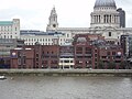
 Waterfront side of Baynard House
 -
 Waterfront side of Baynard House and Blackfriars Railway bridge. Viewed from the Millennium Bridge.
 -
 Baynard House and Faraday Building (green roof) on the left, City of London School centre on the north bank of the River Thames, London. Shows height of construction restriction.


